Sierra Vista is a city in Cochise County, Arizona, United States. According to the 2020 Census, the population of the city is 45,308, and is the 27th most populous city in Arizona. The city is part of the Sierra Vista-Douglas Metropolitan Area, with a 2010 population of 131,346. Fort Huachuca, a U.S. Army post, has been incorporated and is located in the northwest part of the city. Sierra Vista is bordered by the cities of Huachuca City and Whetstone to the north and Sierra Vista Southeast to the South.

Chiricahua National Monument is a unit of the National Park System located in the Chiricahua Mountains of southeastern Arizona. The monument was established on April 18, 1924, to protect its extensive hoodoos and balancing rocks. The Faraway Ranch, which was owned at one time by Swedish immigrants Neil and Emma Erickson, is also preserved within the monument.
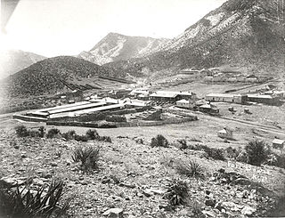
Fort Bowie was a 19th-century outpost of the United States Army located in southeastern Arizona near the present day town of Willcox, Arizona. The remaining buildings and site are now protected as Fort Bowie National Historic Site.

Kentucky Camp is a ghost town and former mining camp along the Arizona Trail in Pima County, Arizona, United States, near the community of Sonoita. The Kentucky Camp Historic District is listed on the National Register of Historic Places and has been since 1995. As it is located within Coronado National Forest, the United States Forest Service is responsible for the upkeep of the remaining buildings within the Kentucky Camp Historic District.

San Bernardino Ranch is a historic ranch house in the southern San Bernardino Valley near the San Bernardino National Wildlife Refuge in extreme southeast Cochise County, Arizona, United States. It is significant for its association with the beginning of cattle ranching in southern Arizona and northern Mexico. The ranchland and valley are part of the headwaters region of the Yaqui River.
The Sierra Bonita Ranch, founded in 1872 by Henry C. Hooker, is one of the oldest cattle ranches in the United States and the ranch buildings have been designated a National Historic Landmark. It was the first permanent American cattle ranch in Arizona. Hooker bought neighboring ranches until his operation became the largest ranch in Arizona, totaling 800 square miles (2,100 km2), or about 30 by 27 miles. It is located in Sulphur Springs Valley about 27 miles (43 km) north of present-day Willcox, Arizona. The modern ranch is much smaller but is still operational and owned by Jesse Hooker Davis, the sixth generation to live and work on the ranch.
Hereford is a populated place in Cochise County along the San Pedro Riparian National Conservation Area in the southern part of the U.S. state of Arizona. It is southeast of Sierra Vista and is a part of the Sierra Vista-Douglas micropolitan area. The elevation is 4,193 feet at the location of the original townsite at the far eastern end of the unincorporated area; the residential area runs for another 8 miles west from this location, blending into the unincorporated area of Nicksville at an elevation of approximately 4800'. Hereford Station Post Office is located at the far western end of Nicksville, at the foot of the Huachuca Mountains.

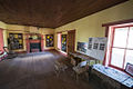
The Faraway Ranch Historic District is part of the Chiricahua National Monument in southeastern Arizona, and preserves an area associated with the final conflicts with the local Apache, one of the last frontier settlements, and in particular, its association with the people who promoted the establishment of the Chiricahua National Monument. Faraway Ranch is located in Bonita Canyon, which lies at an approximate altitude of 5160 feet and opens in a southwesterly direction into the Sulphur Springs Valley.

Canelo Ranger Station, also known as Canelo Work Station, is a historic ranger station in the Coronado National Forest, within Santa Cruz County of southern Arizona. It is located in the ghost town of Canelo, within a small valley between the Canelo Hills on the west and the northern Huachuca Mountains on the east.

Sahuaro Ranch was founded in 1886, by William Henry Bartlett, a native of Illinois. The ranch, located north of what eventually became the city of Glendale, Arizona, was rich in figs and other fruit orchards, vineyards, and fields of alfalfa. The ranch has all of its historical structures restored, and the "Sahuaro Ranch Park" is administered by the Parks and Recreation Department of Glendale.

Manistee Ranch was founded in 1897 by Herbert W. Hamilton, a native of Wisconsin. The ranch, located in the town of Glendale, Arizona, was rich in citrus fruits and dates. The ranch has all of its historical structures restored. It is administered by the Parks and Recreation Department of Glendale.
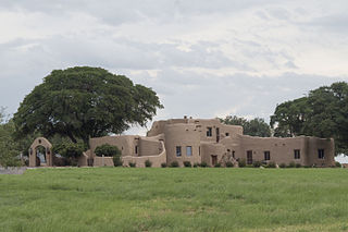
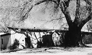
Kinjockity Ranch, also known as Lanteen Ranch, is a Pueblo Revival style residence in Cochise County, Arizona, originally built in 1939-1940 for Rufus Riddlesbarger, a wealthy Chicago businessman. It is a notable example of Pueblo Revival style, executed in adobe with richly detailed interiors and hand-made hardware. The house was designed by Edward C. Morgan, an architect from Phoenix who specialized in what he called "the Mexican style." The interiors were decorated and embellished by illustrator and sculptor Raymond Phillips Sanderson, who had collaborated with Morgan on previous commissions.
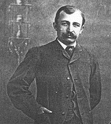
Neil Erickson was a Swedish-born American pioneer in Cochise County, Arizona. He and the members of his family were the founders and operators of Faraway Ranch now in the Faraway Ranch Historic District of the Chiricahua National Monument in the Chiricahua Mountains in southern Arizona.

The San Rafael Ranch, formerly known as the Greene Ranch, is a historic cattle ranch located in the San Rafael Valley about a mile and a half north of Lochiel, Arizona, near the international border with Sonora, Mexico.

The Little Boquillas Ranch is an historic ranch property located in western Cochise County, Arizona, near the Fairbank Historic Townsite in what is now part of the San Pedro Riparian National Conservation Area.

Squaw Peak Inn is a historic structure located at 4425 E. Horseshoe Road in the east end of Piestewa Peak Mountain, formerly known as Squaw Peak Mountain. The inn, which has served as the lodging for various celebrities, was listed in the National Register of Historic Places on January 1, 1995.

Charles Bolsius House, also called "Casa Bienvenidos", is a significant example of the architectural work of artist and designer Charles Bolsius and an important example of Territorial Revival design in the American Southwest. It is located in the City of Tucson, Arizona within the Old Fort Lowell Historic District.