Inverness is an unincorporated community and census-designated place (CDP) located in western Marin County, California. Inverness is located on the southwest shore of Tomales Bay 3.5 miles northwest of Point Reyes Station, at an elevation of 43 feet. In the 2010 census, the population was 1,304. The community is named after Inverness, Scotland and was named by a Scottish landowner.

Point Reyes National Seashore is a 71,028-acre (287.44 km2) park preserve located on the Point Reyes Peninsula in Marin County, California. As a national seashore, it is maintained by the US National Park Service as an important nature preserve. Some existing agricultural uses are allowed to continue within the park. Clem Miller, a US Congressman from Marin County wrote and introduced the bill for the establishment of Point Reyes National Seashore in 1962 to protect the peninsula from development which was proposed at the time for the slopes above Drake's Bay. All of the park's beaches were listed as the cleanest in the state in 2010.
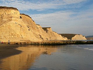
Drakes Bay is a 4 mi (6.4 km) wide bay named so by U.S. surveyor George Davidson in 1875 along the Point Reyes National Seashore on the coast of northern California in the United States, approximately 30 mi (48 km) northwest of San Francisco at approximately 38 degrees north latitude. The bay is approximately 8 mi (13 km) wide. It is formed on the lee side of the coastal current by Point Reyes. The bay is named after Sir Francis Drake and has long been considered Drake's most likely landing spot on the west coast of North America during his circumnavigation of the world by sea in 1579. An alternative name for this bay is Puerto De Los Reyes.

The United States Life-Saving Service was a United States government agency that grew out of private and local humanitarian efforts to save the lives of shipwrecked mariners and passengers. It began in 1848 and ultimately merged with the Revenue Cutter Service to form the United States Coast Guard in 1915.

East Brother Island Lighthouse is a lighthouse located on East Brother Island in San Rafael Bay, near the tip of Point San Pablo in Richmond, California. It marks the entrance to San Pablo Bay from San Francisco Bay.

The Point Reyes Lighthouse, also known as Point Reyes Light or the Point Reyes Light Station, is a lighthouse in the Gulf of the Farallones on Point Reyes in Point Reyes National Seashore, located in Marin County, California, United States.

Mayor Andrew Broaddus is a lifesaving station built by the United States Life-Saving Service located in Louisville, Kentucky, off the corner of River Road and Fourth Street. She is named in honor of Andrew Broaddus (1900-1972), a former mayor of Louisville (1953-1957). Her historic purpose was to protect travelers on the Ohio River from the Falls of the Ohio, with rescue crews for those who fell victim to the rapids. Louisville was the first place where a lifesaving station was placed in western waters. The first lifestation in Louisville was in 1881, with Mayor Andrew Broaddus as the third. A National Historic Landmark, she is the only surviving floating lifesaving station of the US Life-Saving Service.

Klipsan Beach was the site of a station of the United States Life-Saving Service. The station buildings still remain, although they are privately owned. The station is on the National Register of Historic Places. The station's name was originally Ilwaco Beach, and only later became known as Klipsan Station. The station was one of several assigned to provide protection in the area known as the Graveyard of the Pacific.

Glen Haven is a restored port village on the shore of Lake Michigan on the Leelanau Peninsula within the now Sleeping Bear Dunes National Lakeshore. Attractions include the Lake Michigan beach, a restored General Store and Blacksmith Shop. The unincorporated community is located in Glen Arbor Township.

North Manitou Island Lifesaving Station, also known as North Manitou Coast Guard Station, is a complex of buildings located on North Manitou Island, which is part of Sleeping Bear Dunes National Lakeshore in Michigan, in the U.S. The complex was constructed as a life-saving station. It is the only remaining station which was in use during all three periods of lifesaving service history, from the early volunteer period through operation by the United States Life-Saving Service and the United States Coast Guard. It was declared a National Historic Landmark in 1998.
The Damariscove Lifesaving Station is a historic coastal maritime rescue facility, located on Damariscove Island in Boothbay, Maine. The station was built in 1897, and is one of the more architecturally distinguished of the surviving stations. It was listed on the National Register of Historic Places on June 25, 1987. It is now privately owned.
West Quoddy Lifesaving Station is a historic coastal rescue station on West Quoddy Head in Lubec, Maine. The lifesaving station was built in 1919, and was operated by the United States Coast Guard until 1972. It was listed on the National Register of Historic Places on April 20, 1990. It now houses a bed and breakfast inn.

The Humboldt Bay Life-Saving Station was originally built in November 1878 on the north side of the entrance to Humboldt Bay in northern California, United States near Eureka, adjacent to the site of the first Humboldt Harbor Light (1856–1892). Rebuilt in 1936 with marine railways to launch rescue surfboats, the historic facility was placed on the National Register of Historic Places on October 30, 1979. The station continues to function as an important asset of the United States Coast Guard in the Coast Guard Group/Air Station Humboldt Bay.
Coast Guard Station Tillamook Bay is an active duty installation of the United States Coast Guard located in Garibaldi, Oregon, as well as a nationally recognized historic site. A station has been operating in Tillamook Bay since 1908. The station was opened by the United States Life-saving Service a precursor agency to the Coast Guard. The current station has been in continuous operation since 1942.

The Eagle Harbor Coast Guard Station Boathouse is a boathouse located at 9282 Marina Road in Eagle Harbor, Michigan. It was listed on the National Register of Historic Places in 2012.

The Nahant Life-Saving Station is a historic coastal rescue station in Nahant, Massachusetts. The station, which consists of a residence and an equipment building, was established in 1900 by the United States Life-Saving Service before being taken over by the United States Coast Guard in 1915. The station was discontinued in 1964, and the facilities were converted recreational use by the Coast Guard. In 1999 the 1.4 acres (0.57 ha) parcel was turned over to the Town of Nahant. The station, one of twelve such surviving facilities in the state, was listed on the National Register of Historic Places in 2012.

Hayling Island Lifeboat Station is a Royal National Lifeboat Institution station located on Hayling Island close to the town of Mengham in the English county of Hampshire. The station is located on the eastern side of Hayling island at the entrance to Chichester Harbour where it joins the major shipping route of the Solent, and is opposite the village of West Wittering. This major shipping route is busy at all times of the year and there are estimated to be 10,000 boats in the Chichester area alone. The Hayling Island station provides cover for the area 24 hours a day, all year, by means of two inshore rigid inflatable lifeboats placed on this station.

Shoreham Harbour Lifeboat Station is a Royal National Lifeboat Institution (RNLI) station located in the town of Shoreham-by-Sea in the English county of West Sussex. It underwent extensive re-development in 2010 with a new purpose built boathall to accommodate its new Tamar-class all-weather lifeboat (AWB). It operates two lifeboats, the AWB RNLB Enid Collett (ON 1295) and the D-class (IB1) Inshore lifeboat RNLB Joan Woodland (D-784).
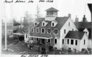
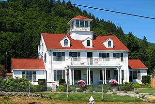
Coast Guard Station Point Adams was a United States Coast Guard base at the mouth of the Columbia River. It was founded in 1888, by the United States Lifesaving Service, one of the service that were amalgamated into the Coast Guard.
Camp Hydle also called Drakes Bay Range was a large training center during World War II, located at Drakes Bay, on what is now Point Reyes National Seashore on the coast of northern California in the United States. The camp had several training sites: Camp Hydle, Drakes Bay Air to Ground Gunnery Range, Drakes Bay Dive Bombing Target, Camp Murphy's Ranch, Camp Hydle Maneuver Area, and Camp Hydle Skip and Dive Bombing Range. Also at the camp were landing craft training and air sea rescue training. The site was 10,532 acres of Marin County, California land on the West Coast of the United States. The complete area from Stinson Beach to the south and Dillon Beach to the north was called the Point Reyes Gunnery Range at Point Reyes. The Gunnery Range also included: two radar towers, horse stable, two lifeboat Stations, the Point Reyes Lighthouse, lookout towers, and land strafing targets (rake). The dive bomber airplanes came from Hamilton Army Airfield (AAF), Santa Rosa Army Airfield (AAF), and Naval Air Station Alameda (NAS). In addition to Drakes Bay the planes also training using the nearby Abbotts Lagoon, and Tomales Bay. The landing craft training used Limantour Beach and Limantour Spit. Anti-aircraft gun training was important training for the Pacific War. Camp Hydle base was inland 1/2 mile east of Limantour Beach. For gunner training planes towed targets across Drakes Bay. Ships also trained at the base, like the USS Walton and USS Nevada (BB-36). The Navy's Camp Hydle took over the Point Reyes Lifeboat Station during the war. The 50 men at the Station were air sea rescue pilots, dropping rafts to plane crew that landed in the ocean during training. The first troops arrived at the site on December 7, 1941. The site was also used as a coast defense spot, looking out for Japanese subs and ships. Most of the land was leased from Leland Murphy, after the war in 1962, the site became Point Reyes National Seashore.