Chazy Fossil Reef

Last updated
Chazy Fossil Reef
Chazy Reef Isle La Motte.jpg
Stromatoporoid at Fisk Quarry, Isle La Motte, Vermont
USA Vermont location map.svg
Red pog.svg
USA New York location map.svg
Red pog.svg
Usa edcp location map.svg
Red pog.svg
Location Clinton County, New York
Grand Isle County, Vermont
Coordinates 44°51′10″N73°20′24″W / 44.8528°N 73.3400°W / 44.8528; -73.3400
Area1,567 acres (6.34 km2)
Governing bodyMixed (federal, state, and private)
DesignatedMay 2009

Chazy Fossil Reef is a United States National Natural Landmark spanning three Lake Champlain islands in Clinton County, New York and Grand Isle County, Vermont. The site is recognized as the oldest known diverse fossil reef in the world, and contains fossils that demonstrate faunal succession. [1] The 1,567-acre (6.34 km2) site was dedicated as a National Natural Landmark in May 2009. [1]

Contents

Location

The Chazy Fossil Reef National Natural Landmark includes three islands in Lake Champlain. Included within the designated area are two preserves on Vermont's Isle La Motte; the 20-acre (8.1 ha)Fisk Quarry Preserve and the 83-acre (34 ha)Goodsell Ridge Preserve are both open to the public and managed by the Isle La Motte Preservation Trust. [2] New York's Valcour Island and Garden Island are also included as part of the landmark. [3]

Fossils

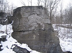
The reef is an observable portion of the larger Chazy Formation which extends from Quebec to Tennessee. [4] The location features an exposed Ordovician fossil reef, approximately 450 to 480 million years old, containing fossils from what was once a tropical marine environment. [5] The site is recognized as the oldest known fossil reef that contains substantial biological diversity. [1]

Strata from successive periods of time may be viewed across the landscape due to the tilted orientation of the sedimentary rock layers. [4] The presence of fossils from a continuous time series allow for the observation of faunal succession. [6] On Isle La Motte, the oldest fossils occur at the southern end of the island, with progressively newer layers visible toward the island's north end. [4]

Among the preserved specimens are prehistoric stromatoporoids, gastropods, cephalopods, echinoderms, brachiopods, sponges, coral, bryozoa and stromatolites. [6]

See also

Related Research Articles

<span class="mw-page-title-main">Lake Champlain</span> Lake in New York, Vermont and Quebec

Lake Champlain is a natural freshwater lake in North America. It mostly lies between the US states of New York and Vermont, but also extends north into the Canadian province of Quebec.

<span class="mw-page-title-main">Clinton County, New York</span> County in New York, United States

Clinton County is a county in the north-easternmost corner of the state of New York, in the United States and bordered by the Canadian province of Quebec. As of the 2020 United States Census, the population was 79,843. Its county seat is the city of Plattsburgh. The county lies just south of the border with the Canadian province of Quebec and to the west of the State of Vermont.

<span class="mw-page-title-main">Chazy, New York</span> Town in New York, United States

Chazy is a town in northeastern Clinton County, New York, United States. The population was 4,284 at the 2010 census. The closest city is Plattsburgh, 14 miles (23 km) to the south. Chazy is 8 miles (13 km) south of the Canada–United States border. The ZIP code is 12921 and the community is in area code 518.

<span class="mw-page-title-main">Isle La Motte</span> Town in Vermont, United States

Isle La Motte is an island in Lake Champlain in northwestern Vermont, United States. At 7 mi (11 km) by 2 mi (3 km), it lies close to the place that the lake empties into the Richelieu River. It is incorporated as a New England town in Grand Isle County. Its population was 488 at the 2020 census.

<span class="mw-page-title-main">North Hero, Vermont</span> Town in Vermont, United States

North Hero is a town in and the shire town of Grand Isle County, Vermont, United States. The population was 939 at the 2020 census.

<span class="mw-page-title-main">Champlain, New York</span> Town in the United States

Champlain is a town in Clinton County, New York, United States. The population was 5,754 at the 2010 census. The town is located on the western shore of Lake Champlain, near the northern end of Lake Champlain and is on the U.S./Canadian border.

<span class="mw-page-title-main">Orient Beach State Park</span> State park in New York, United States

Orient Beach State Park is a 363-acre (1.47 km2) state park located in Southold, New York. The park is situated at the tip of the North Fork of Long Island.

<span class="mw-page-title-main">Missisquoi National Wildlife Refuge</span>

Missisquoi National Wildlife Refuge is a National Wildlife Refuge located in the eastern shore of Lake Champlain in the U.S. state of Vermont. The refuge is in Franklin County in the northwest corner of the state near the International Boundary with Canada. It is the only National Wildlife Refuge located entirely in Vermont, and is administered by the United States Fish and Wildlife Service.

<span class="mw-page-title-main">National Natural Landmark</span> Natural areas program in the U.S.

The National Natural Landmarks (NNL) Program recognizes and encourages the conservation of outstanding examples of the natural history of the United States. It is the only national natural areas program that identifies and recognizes the best examples of biological and geological features in both public and private ownership. The program was established on May 18, 1962, by United States Secretary of the Interior Stewart Udall.

<span class="mw-page-title-main">New York State Route 191</span> Highway in New York

New York State Route 191 (NY 191) was a 6.24-mile (10.04 km) long state highway located north of Adirondack Park. The route was maintained and co-designated by the Clinton County highway department as County Route 23 (CR 23) and headed from an intersection with NY 22 in the hamlet of Sciota within the town of Chazy to a junction with U.S. Route 9 (US 9) in the hamlet of Chazy. The route met Interstate 87 west of Chazy hamlet.

<span class="mw-page-title-main">Chazy Formation</span>

The Chazy Reef Formation is a mid-Ordovician limestone deposit in northeastern North America.

<span class="mw-page-title-main">Vermont Route 129</span> State highway in Grand Isle County, Vermont, US

Vermont Route 129 (VT 129) is a short, 5.415-mile-long (8.715 km) connector route for Isle La Motte and Alburgh in the state of Vermont in the United States. VT 129 begins at an intersection in the centre of Isle La Motte, heads northward and terminates at an intersection with U.S. Route 2 in Alburgh. The route originated as Vermont Route F-2 in 1926, and was the name of the road that approached a ferry to Chazy. Route F-2 followed the same routing as the current VT 129, to which it was renumbered in 1944.

<span class="mw-page-title-main">Geography of Vermont</span> Overview of the Geography of Vermont

The U.S. state of Vermont is located in the New England region of the northeastern United States and comprises 9,614 square miles (24,900 km2), making it the 45th-largest state. It is the only state that does not have any buildings taller than 124 feet (38 m). Land comprises 9,250 square miles (24,000 km2) and water comprises 365 square miles (950 km2), making it the 43rd-largest in land area and the 47th in water area. In total area, it is larger than El Salvador and smaller than Haiti. It is the only landlocked state in New England, and it is the easternmost and the smallest in area of all landlocked states.

<span class="mw-page-title-main">Valcour Island</span>

Valcour Island is a 968-acre (3.92 km2) island in Lake Champlain in Clinton County, New York, United States. The island is mostly in the Town of Peru and partly in the Town of Plattsburgh, southeast of the City of Plattsburgh. It is within the boundaries of the Adirondack Park.

<span class="mw-page-title-main">Fossiliferous limestone</span> Limestone containing fossils

Fossiliferous limestone is a type of limestone that contains noticeable quantities of fossils or fossil traces. If a particular type of fossil dominates, a more specialized term can be used as in "Crinoidal", "Coralline", "Conchoidal" limestone. If seashells, shell fragments, and shell sand form a significant part of the rock, a term "shell limestone" is used.

<span class="mw-page-title-main">Nelson W. Fisk</span> American businessman and politician from Vermont

Nelson Wilbur Fisk was a Vermont businessman and political figure who served as the 41st lieutenant governor of Vermont from 1896 to 1898.

<span class="mw-page-title-main">Knight Point State Park</span> State park in Grand Isle County, Vermont

Knight Point State Park is a day use state park off US Route 2 on North Hero Island in North Hero, Vermont. Opened in 1978, the park is administered by the Vermont Department of Forests, Parks, and Recreation, as part of the Vermont State Park system. Features include a sandy swimming beach and boat rentals on Lake Champlain, and picnic areas with cooking grills.

The General Butler was a schooner-rigged sailing canal boat that plied the waters of Lake Champlain and the Champlain Canal in the United States states of Vermont and New York. Built in 1862 and named for American Civil War General Benjamin Franklin Butler, she sank after striking the Burlington Breakwater in 1876, while carrying a load of marble. Her virtually intact wreck, discovered in 1980, is a Vermont State Historic Site and a popular dive site; it was listed on the National Register of Historic Places in 1998.

References

  1. 1 2 3 "Chazy Fossil Reef". National Natural Landmarks Program. National Park Service. June 28, 2012. Retrieved September 16, 2016.
  2. "Preserves". Isle La Motte Preservation Trust. Retrieved September 16, 2016.
  3. Winslow, Mike. "The Chazy Reef". Lake Champlain Committee. Retrieved September 16, 2016.
  4. 1 2 3 "A Walk Through Time". Isle La Motte Preservation Trust. Archived from the original on April 14, 2016. Retrieved September 16, 2016.
  5. Braun, David Maxwell (February 4, 2009). "U.S. Designates Four New National Natural Landmarks". Voices. National Geographic Society. Archived from the original on December 21, 2016. Retrieved September 16, 2016.
  6. 1 2 Mehrtens, Charlotte (1998). "Geology of Vermont - Chazy Reef at Isle LaMotte". Vermont Geological Survey. Archived from the original on March 6, 2016. Retrieved September 16, 2016.