
Mount Katahdin is the highest mountain in the U.S. state of Maine at 5,269 feet (1,606 m). Named Katahdin, which means "Great Mountain", by the Penobscot Native Americans, it is within Northeast Piscataquis, Piscataquis County, and is the centerpiece of Baxter State Park. It is a steep, tall massif formed from a granite intrusion weathered to the surface. The flora and fauna on the mountain are typical of those found in northern New England, with the summit hosting fragile and endangered alpine tundra.

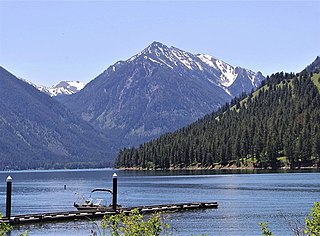
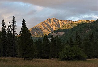
The Wallowa Mountains are a mountain range located in the Columbia Plateau of northeastern Oregon in the United States. The range runs approximately 40 miles (64 km) northwest to southeast in southwestern Wallowa County and eastern Union County between the Blue Mountains to the west and the Snake River to the east. The range is sometimes considered to be an eastern spur of the Blue Mountains, and it is known as the "Alps of Oregon". Much of the range is designated as the Eagle Cap Wilderness, part of the Wallowa–Whitman National Forest.

The Wallowa River is a tributary of the Grande Ronde River, approximately 55 miles (89 km) long, in northeastern Oregon in the United States. It drains a valley on the Columbia Plateau in the northeast corner of the state north of Wallowa Mountains.

Mount of the Holy Cross is a high and prominent mountain summit in the northern Sawatch Range of the Rocky Mountains of North America. The 14,011-foot (4270.5 m) fourteener is located in the Holy Cross Wilderness of White River National Forest, 6.6 miles (10.7 km) west-southwest of the Town of Red Cliff in Eagle County, Colorado, United States. The summit of Mount of the Holy Cross is the highest point in Eagle County and the northern Sawatch Range.

Mount Bigelow is a long mountain ridge with several summits. It is located in Franklin County and Somerset County, Maine. It is one of Maine's highest summits. The mountain is named after Major Timothy Bigelow who climbed the rugged summit in late October 1775 "for the purpose of observation." Major Bigelow was one of Colonel Benedict Arnold's four division commanders during the 1775 Invasion of Canada. The expeditionary force passed along the Dead River on the northern edge of the Bigelow Range, now dammed into Flagstaff Lake.

The Wallowa Lake Tramway is an aerial cable gondola lift near Joseph, Oregon, in the Wallowa-Whitman National Forest of the United States, named for Wallowa Lake. The tram runs from the floor of the Wallowa Valley to the top of Mount Howard. It travels to an elevation of 8,000 feet (2,400 m) above sea level and allows for views of the Eagle Cap Wilderness area and the rest of the Wallowa Mountains.

Eagle Cap Wilderness is a wilderness area located in the Wallowa Mountains of northeastern Oregon, within the Wallowa–Whitman National Forest. The wilderness was established in 1940. In 1964, it was included in the National Wilderness Preservation System. A boundary revision in 1972 added 73,000 acres (30,000 ha) and the Wilderness Act of 1964 added 66,100 acres (26,700 ha) resulting in a current total of 361,446 acres, making Eagle Cap by far Oregon's largest wilderness area.

Mount Rose is the highest mountain in Washoe County, within the Carson Range of Nevada, United States. It ranks thirty-seventh among the most topographically prominent peaks in the state. It is also both the highest and most topographically prominent peak of the greater Sierra Nevada range within the state of Nevada, and the third most topographically prominent peak in the Sierra Nevada overall. It is located in the Mount Rose Wilderness of the Humboldt-Toiyabe National Forest. An extinct volcano, the mountain is in between Lake Tahoe and Reno. State Route 431 traverses Mount Rose Summit southeast of Mount Rose. Due to the high elevation, most of the precipitation that falls on the mountain is snow. The view from Mount Rose facing east is the Truckee Meadows, the second largest population center in Nevada.
Mount Ireland is a mountain in Grant County of the U.S. state of Oregon. It is about 5 miles (8 km) east-northeast of Granite, Oregon. It is the shortest and westernmost 8000'+ peak in the Elkhorn Range of the Blue Mountains at 8,321 feet (2,536 m), and Oregon's 71st highest peak with at least a 500' clean prominence. For a period of several years, this mountain peak was referred to as Bald Mountain, but in 1917 it was changed to Ireland Mountain—in commemoration of the late Henry Ireland, who for 10 years was supervisor of the Whitman National Forest in which the mountain is located—before formally becoming known as Mount Ireland. The name change was brought about by a cooperative effort of local citizens and the US Forest Service to honor Henry Ireland, who had died in 1916.

Sacajawea Peak is a peak in the Wallowa Mountains, in the U.S. state of Oregon. It is in the Eagle Cap Wilderness and the Wallowa–Whitman National Forest.
Eagle Cap is a mountain peak located in the Wallowa Mountains, Wallowa–Whitman National Forest, in the U.S. state of Oregon. The peak is in the Eagle Cap Wilderness and the Benson Glacier is along the east flank of the summit ridge. Its summit is the highest point in Union County.

The McCully Basin is a geologic structural basin in the northern boundary of Eagle Cap Wilderness in northeast Oregon. The basin is the topographic drainage of McCully Creek. Several Alpine Huts and campsite are located throughout the McCully Basin, which are used as a base camp in the winter for telemark skiing.

Mount Nebo is a 8,261-foot (2,518 m) mountain in the Eagle Cap Wilderness of Oregon, in the United States. Named after the biblical Mount Nebo overlooking Israel, which is said to be the place of Moses' death. It is the centerpiece of the Imnaha Divide, inside the Wallowa–Whitman National Forest. Mount Nebo is one of the important areas where sheep and cattle graze throughout Eagle Cap Wilderness.

Chief Joseph Mountain is a 9,616-foot elevation (2,931 m) mountain summit located in Wallowa County, Oregon, US.

Matterhorn is a 9,835-foot elevation (2,998 m) mountain summit located in Wallowa County, Oregon, US.

Craig Mountain is a 9,204-foot elevation (2,805 m) mountain summit located in Wallowa County, Oregon, US.
Bonneville Mountain is an 8,140-foot elevation (2,481 m) mountain summit located in Wallowa County, Oregon, US.

Glacier Peak is a 9,495-foot elevation (2,894 m) mountain summit located in Union County, Oregon, US.

Cornucopia Peak is a mountain summit located in Baker County, Oregon, US.
Krag Peak is a mountain summit located in Baker County, Oregon, US.

