South Fork South Platte River

Last updated
South Fork South Platte River [1]

South Fork South Platte River.JPG

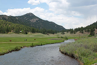
The river near Hartsel, Colorado.
Physical characteristics
Main source Park County, Colorado
39°07′42″N106°10′39″W / 39.12833°N 106.17750°W / 39.12833; -106.17750
River mouth Confluence with Middle Fork South Platte River
8,776 ft (2,675 m)
39°00′40″N105°44′25″W / 39.01111°N 105.74028°W / 39.01111; -105.74028 Coordinates: 39°00′40″N105°44′25″W / 39.01111°N 105.74028°W / 39.01111; -105.74028
Basin features
Progression South PlattePlatte
MissouriMississippi

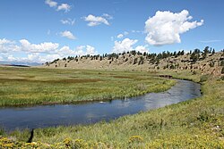
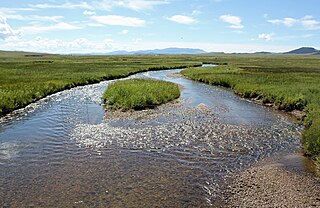
The South Fork South Platte River is a tributary of the South Platte River, approximately 45 miles (72 km) long, [2] in central Colorado in the United States. It is located near the headwaters of the South Platte in Park County, Colorado and drains part of the intermontane grassland basin of South Park. It forms the South Platte by its confluence with the Middle Fork South Platte River in southern South Park. [3]

South Platte River principal tributary of the Platte River

The South Platte River is one of the two principal tributaries of the Platte River. Flowing through the U.S. states of Colorado and Nebraska, it is itself a major river of the American Midwest and the American Southwest/Mountain West. Its drainage basin includes much of the eastern flank of the Rocky Mountains in Colorado; much of the populated region known as the Colorado Front Range and Eastern Plains; and a portion of southeastern Wyoming in the vicinity of the city of Cheyenne. It joins the North Platte River in western Nebraska to form the Platte, which then flows across Nebraska to the Missouri. The river serves as the principal source of water for eastern Colorado. In its valley along the foothills in Colorado, it has permitted agriculture in an area of the Colorado Piedmont and Great Plains that is otherwise arid.

Colorado State of the United States of America

Colorado is a state of the Western United States encompassing most of the southern Rocky Mountains as well as the northeastern portion of the Colorado Plateau and the western edge of the Great Plains. It is the 8th most extensive and 21st most populous U.S. state. The estimated population of Colorado was 5,695,564 on July 1, 2018, an increase of 13.25% since the 2010 United States Census.

United States federal republic in North America

The United States of America (USA), commonly known as the United States or America, is a country composed of 50 states, a federal district, five major self-governing territories, and various possessions. At 3.8 million square miles, the United States is the world's third or fourth largest country by total area and is slightly smaller than the entire continent of Europe's 3.9 million square miles. With a population of over 327 million people, the U.S. is the third most populous country. The capital is Washington, D.C., and the largest city by population is New York City. Forty-eight states and the capital's federal district are contiguous in North America between Canada and Mexico. The State of Alaska is in the northwest corner of North America, bordered by Canada to the east and across the Bering Strait from Russia to the west. The State of Hawaii is an archipelago in the mid-Pacific Ocean. The U.S. territories are scattered about the Pacific Ocean and the Caribbean Sea, stretching across nine official time zones. The extremely diverse geography, climate, and wildlife of the United States make it one of the world's 17 megadiverse countries.

It rises on the eastern flank of the Mosquito Range, below Weston Pass north of Buffalo Peaks in the Pike National Forest. It descends through a short narrow gorge to the southeast, then turns east to emerge into the eastern side of South Park approximately 10 miles (16 km) south of the town of Fairplay. It turns south, skirting the base of the mountains and flowing along the eastern side of U.S. Highway 285, then turns east, winding in a course that roughly follows U.S. Highway 24. It joins the Middle Fork to form the main branch of the South Platte near the community of Hartsel.

Mosquito Range

The Mosquito Range is a high mountain range in the Rocky Mountains of central Colorado in the United States. The peaks of the range form a ridge running north-south for approximately 40 miles (64 km) from southern Summit County on the north end, then along the boundary between Lake and Park counties. The ranges forms a high barrier separating the headwaters of the Arkansas River near Leadville from South Park and the headwaters of the South Platte River near Fairplay. The highest peak in the range is Mount Lincoln at an elevation of 14,286 ft. Other fourteeners in the range are Quandary Peak, Mount Bross (14,172 ft), Mount Democrat (14,148 ft), and Mount Sherman (14,036 ft).

Pike National Forest

The Pike National Forest is located in the Front Range of Colorado, United States, west of Colorado Springs including Pikes Peak. The forest encompasses 1,106,604 acres (4,478 km²) within Clear Creek, Teller, Park, Jefferson, Douglas and El Paso counties. The major rivers draining the forest are the South Platte and Fountain Creek. Rampart Reservoir, a large artificial body of water, is located within the forest.

Fairplay, Colorado Statutory Town in Colorado, United States

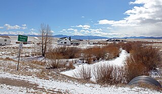
Fairplay is the statutory town that is the county seat and the most populous municipality of Park County, Colorado, United States. Fairplay is located in South Park at an elevation of 9,953 feet (3,034 m). The town is the fifth-highest incorporated place in the State of Colorado. The population was 679 at the U.S. Census 2010.

See also

Related Research Articles

South Park (Park County, Colorado) high intermontane grassland basin in the Rocky Mountains of central Colorado

South Park is a grassland flat within the basin formed by the Rocky Mountains' Mosquito and Park Mountain Ranges within central Colorado. This high valley ranges in elevation from approximately 9,000 to 10,000 ft. It encompasses approximately 1,000 square miles around the headwaters of the South Platte River in Park County approximately 60 mi (100 km) southwest of Denver. It is the largest and southernmost of three similarly named high altitude basins in the Front Range of Colorado, the others being North Park and Middle Park. The largest town in the basin is Fairplay, with a population of 681.

Platte River river in Nebraska, United States

The Platte River is a major river in the state of Nebraska and is about 310 mi (500 km) long. Measured to its farthest source via its tributary the North Platte River, it flows for over 1,050 miles (1,690 km). The Platte River is a tributary of the Missouri River, which itself is a tributary of the Mississippi River which flows to the Gulf of Mexico. The Platte over most of its length is a muddy, broad, shallow, meandering stream with a swampy bottom and many islands—a braided stream. These characteristics made it too difficult for canoe travel, and it was never used as a major navigation route by European-American trappers or explorers.

North Platte River major tributary of the Platte River

The North Platte River is a major tributary of the Platte River and is approximately 716 miles (1,152 km) long, counting its many curves. In a straight line, it travels about 550 miles (890 km), along its course through the U.S. states of Colorado, Wyoming, and Nebraska.

Blue River (Colorado) tributary of the Colorado River in Colorado, USA

The Blue River is a tributary of the Colorado River, approximately 65 miles (105 km) long, in the U.S. state of Colorado.

White River (Green River tributary) river in Colorado and Utah, United States

White River is a river, approximately 195 miles (314 km) long, in the U.S. states of Colorado and Utah and is a tributary of the Green River.

Middle Park (Colorado basin) high basin in the Rocky Mountains of Colorado, United States

Middle Park is a high basin in the Rocky Mountains of north-central Colorado in the United States. It is located in Grand County, on the southwest slope of Rocky Mountain National Park, approximately 50 miles (80 km) west of Boulder.

Clear Creek (Colorado) tributary of the South Platte River in north central Colorado in the United States

Clear Creek is a tributary of the South Platte River, approximately 66 miles (106 km) long, in north central Colorado in the United States. The creek flows through Clear Creek Canyon in the Rocky Mountains directly west of Denver, descending through a long gorge to emerge on the Colorado Eastern Plains where it joins the South Platte. Clear Creek is unusual in that it is a stream named "creek" fed by a stream named "river". Fall River empties into Clear Creek along I-70 west of Idaho Springs, Colorado.

Michigan River river in the United States of America

The Michigan River is a tributary of the North Platte River, approximately 69 miles (111 km) long, in north central Colorado in the United States. It drains a rural part of the eastern side of North Park in eastern Jackson County. The river issues from Michigan Lakes, a chain of alpine lakes at 11,208 ft (3,416 m), along the continental divide in southeast Jackson County just east of Nokhu Crags. It descends north then west to flow past the south end of Cameron Pass, and descends from the pass along the route of State Highway 14, past Gould, then northwest through the ranch country of North Park, where it becomes a largely braided stream with a wide river bottom. It passes just east of Walden, and receives the Illinois River from the south just north of Walden. It joins the North Platte from the south approximately 5 miles (8 km) downstream to the north.

The Canadian River is a tributary of the North Platte River, approximately 55 miles (89 km) long, located in Jackson County in north central Colorado in the United States. It drains the eastern edge of the North Park basin along the western side of Medicine Bow Mountains.

St. Vrain Creek river in the United States of America

St. Vrain Creek is a tributary of the South Platte River, approximately 32.2 miles (51.8 km) long, in north central Colorado in the United States. It drains part of the foothills north of Boulder and the Colorado Piedmont area in the vicinity of Longmont.

North Fork South Platte River river in the United States of America

The North Fork South Platte River is a tributary of the South Platte River, approximately 50 miles (80 km) long, in central Colorado in the United States. The river is located near the headwaters of the South Platte in the Rocky Mountains southwest of Denver, draining a rugged area of the Front Range just south of the basin of Clear Creek.

Grant, Colorado Unincorporated community in Colorado, United States

Grant is an unincorporated community and a U.S. Post Office in Park County, Colorado, United States. The community is located in foothills of the Front Range in the Platte Canyon, in the upper valley of the North Fork South Platte River, approximately 6 miles (10 km) east of Kenosha Pass. It sits along U.S. Highway 285 approximately 40 miles (64 km) southwest of Denver. It consists largely of a retired general store, post office, and surrounding houses and trailers along the south side of the highway and along the north side of the river. The Grant Post Office has the ZIP Code 80448. Grant is located at the mouth of Geneva Creek where it descends southward from the Front Range. County Road 62 follows the creek northward to Guanella Pass, leading to Georgetown in the canyon of Clear Creek.

Middle Fork South Platte River river in the United States of America

The Middle Fork South Platte River is a tributary of the South Platte River, approximately 50 miles (80 km) long, located in central Colorado in the United States. The river provides part of the drainage of South Park, the intermontane grassland basin located between the Front Range and the Mosquito Range in the Rocky Mountains southwest of Denver.

Tarryall Creek

Tarryall Creek is a tributary of the South Platte River, approximately 68.5 miles (110.2 km) long, in Park County in central Colorado in the United States. It drains a rural portion of north and central South Park, an intermontane grassland in the Rocky Mountains southwest of Denver. It rises in the high Rockies in several forks along the Continental Divide in the Pike National Forest southwest of Boreas Pass. It descends to the southwest through a short canyon, emerging into South Park near Como, Colorado. It crosses U.S. Highway 285 east of Red Hill Pass northeast of Fairplay, the county seat of Park County, then meanders towards the southeast, joining the South Platte from the east in the southeastern corner of South Park.

The North Fork Cache la Poudre River is a tributary of the Cache la Poudre River, approximately 59.2 miles (95.3 km) long, in north central Colorado in the United States. It drains a mountainous area of north central Larimer County northwest of Fort Collins on the western side of the Laramie Foothills.

Boulder Creek (Colorado) river in the United States of America

Boulder Creek is a 31.4-mile-long (50.5 km) creek draining the Rocky Mountains to the west of Boulder, Colorado, as well as the city itself and surrounding plains.

Crow Creek is a 153-mile-long (246 km) waterway of southeastern Wyoming and northern Colorado. Crow Creek is formed by the merger of the South Fork of Crow Creek with the Middle fork of Crow Creek, with the quick addition of the North Fork of Crow Creek about 1.5 miles (2.4 km) downstream. All the major tributaries of Crow Creek begin in the Laramie Range and flow eastward. The headwaters of the North Fork are dammed to form North Crow reservoir, which supplies the city of Cheyenne. The middle fork is also dammed forming Granite and Crystal reservoirs, also supplying water for Cheyenne. The South Fork is the only unobstructed section and flows most of the year but not all the way to Cheyenne. Other tributaries of Crow Creek below the reservoirs are Sand Creek, Spring Creek and Brush Creek, none of which flow year round. Crow Creek continues in an eastward direction passing through the city of Cheyenne, and then heads east and south into Colorado where it eventually meets the South Platte River.

Piedra River (Colorado) river in the United States of America

The Piedra River is a river in the U.S. state of Colorado. It drains parts of Archuleta, Hinsdale, and Mineral counties along a mainstem length of about 40 miles (64 km). The river flows through a series of isolated box canyons, emptying into the San Juan River at Navajo Lake. Its name stems from the Spanish word, piedra, meaning rock.

Puerco River river in the United States of America

The Puerco River or Rio Puerco is a tributary of the Little Colorado River in northwestern New Mexico and northeastern Arizona. It flows through arid terrain, including the Painted Desert.

References

  1. "South Fork South Platte River". Geographic Names Information System . United States Geological Survey . Retrieved 2011-01-26.
  2. U.S. Geological Survey. National Hydrography Dataset high-resolution flowline data. The National Map, accessed March 25, 2011
  3. "Interactive Journey" Archived 2010-01-28 at the Wayback Machine .. Coalition for the Upper South Platte. Retrieved 16 January 2010.