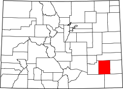
Fort Lyon, Colorado

Last updated
Fort Lyon, Colorado
Coordinates: 38°05′48″N103°09′07″W / 38.09667°N 103.15194°W / 38.09667; -103.15194
Country Flag of the United States.svg  United States
State Flag of Colorado.svg  Colorado
Counties Bent [1]
Elevation
[1]
3,888 ft (1,185 m)
Time zone UTC-7 (MST)
  Summer (DST) UTC-6 (MDT)
ZIP code [2]
81054
Area code 719

Fort Lyon is an unincorporated community and U.S. Post Office in Bent County, Colorado, United States. The Fort Lyon Post Office had the ZIP Code 81038, though the zip code for nearby Las Animas (81054) is also used. [2]

Contents

A post office called Fort Lyon was established in 1862. [3] The community was named after Nathaniel Lyon, an officer in the American Civil War. [4]

History

Several Civil War missions occurred at Fort Lyon, including the 1st New Mexico Volunteer Infantry, Reorganized, the 9th Kansas Cavalry Regiment, and the 15th Infantry Regiment.

McLain's Independent Light Artillery Battery was an artillery battery serving in the Union Army.

The Sand Creek massacre also occurred in the community.

Fort Dodge was used to maintain order along the Santa Fe Trail between there and Fort Lyon.

Galvanized Yankees in the 2nd U.S. Volunteer Infantry traveled from Fort Leavenworth, Kansas, to Fort Lyon. [5]

Some German prisoners of war were buried at Fort Lyon and built furniture and worked on local roads. [6]

The ghost town of Sheridan, in Logan County, Kansas, became a railhead for westbound freight to the Santa Fe Trail on a 120-mile (190 km) wagon road to the area. [7]

Geography

Fort Lyon is located at 38°05′48″N103°09′07″W / 38.09667°N 103.15194°W / 38.09667; -103.15194 (38.096741,-103.152008).

Climate

According to the Köppen Climate Classification system, Fort Lyon has a semi-arid climate, abbreviated "BSk" on climate maps. [8]

Notable people

Related Research Articles

<span class="mw-page-title-main">Las Animas, Colorado</span> City in Colorado, United States

Las Animas is the statutory city that is the county seat, the most populous community, and the only incorporated municipality in Bent County, Colorado, United States. The city population was 2,300 at the 2020 United States Census. Las Animas is located on the Arkansas River, just west of its confluence with the Purgatoire River, in southeast Colorado east of Pueblo, near the historic Bent's Fort.

<span class="mw-page-title-main">Holly, Colorado</span> Town in Colorado, United States

The Town of Holly is a statutory town in Prowers County in southeastern Colorado, United States, near the Kansas border. Located four miles (6 km) from the Kansas border at an elevation of 3,392 feet (1,034 m), Holly is the lowest elevation town in Colorado. The town population was 837 at the 2020 United States Census.

<span class="mw-page-title-main">Gardner, Kansas</span> City in Kansas, United States

Gardner is a city in Johnson County, Kansas, United States. As of the 2020 census, the population of the city was 23,287. It is located inside of the Kansas City metropolitan area.

<span class="mw-page-title-main">Lost Springs, Kansas</span> City in Marion County, Kansas

Lost Springs is a city in Marion County, Kansas, United States. It was named for the old lost spring near the city. As of the 2020 census, the population of the city was 55. It is located south of Herington, about 0.6 miles west of the intersection of U.S. Route 77 highway and 340th Street next to the Union Pacific Railroad.

<span class="mw-page-title-main">Council Grove, Kansas</span> City in Morris County, Kansas

Council Grove is a city and county seat in Morris County, Kansas, United States. As of the 2020 census, the population of the city was 2,140. It was named after an agreement between American settlers and the Osage Nation allowing settlers' wagon trains to pass westward through the area on the Santa Fe Trail. Pioneers gathered at a grove of trees so that wagons could band together for their trip west.

<span class="mw-page-title-main">Larned, Kansas</span> City in Pawnee County, Kansas

Larned is a city in and the county seat of Pawnee County, Kansas, United States. As of the 2020 census, the population of the city was 3,769.

<span class="mw-page-title-main">Lyons, Kansas</span> City in Rice County, Kansas

Lyons is a city in and the county seat of Rice County, Kansas, United States. As of the 2020 census, the population of the city was 3,611.

<span class="mw-page-title-main">Alexander, Kansas</span> City in Rush County, Kansas

Alexander is a city in Rush County, Kansas, United States. As of the 2020 census, the population of the city was 54.

<span class="mw-page-title-main">Fort Riley</span> United States Army installation located in North Central Kansas

Fort Riley is a United States Army installation located in North Central Kansas, on the Kansas River, also known as the Kaw, between Junction City and Manhattan. The Fort Riley Military Reservation covers 101,733 acres (41,170 ha) in Geary and Riley counties. The portion of the fort that contains housing development is part of the Fort Riley census-designated place, with a residential population of 7,761 as of the 2010 census. The fort has a daytime population of nearly 25,000. The ZIP Code is 66442.

<span class="mw-page-title-main">Santa Fe Trail</span> 19th-century route through central North America between Franklin, MO, and Santa Fe, NM

The Santa Fe Trail was a 19th-century route through central North America that connected Franklin, Missouri, with Santa Fe, New Mexico. Pioneered in 1821 by William Becknell, who departed from the Boonslick region along the Missouri River, the trail served as a vital commercial highway until 1880, when the railroad arrived in Santa Fe. Santa Fe was near the end of El Camino Real de Tierra Adentro which carried trade from Mexico City. The trail was later incorporated into parts of the National Old Trails Road and U.S. Route 66.

<span class="mw-page-title-main">Fort Larned National Historic Site</span> National Historic Site of the United States

Fort Larned National Historic Site preserves Fort Larned which operated from 1859 to 1878. It is approximately 5.5 miles (8.9 km) west of Larned, Kansas, United States.

<span class="mw-page-title-main">Fort Hays</span>

Fort Hays, originally named Fort Fletcher, was a United States Army fort near Hays, Kansas. Active from 1865 to 1889 it was an important frontier post during the American Indian Wars of the late 19th century. Reopened as a historical park in 1929, it is now operated by the Kansas Historical Society as the Fort Hays State Historic Site.

<span class="mw-page-title-main">Burdick, Kansas</span> Unincorporated community in Morris County, Kansas

Burdick is an unincorporated community in Morris County, Kansas, United States. It was named after Ms. Burdick, the sweetheart of a Santa Fe Railroad official in 1887. As of the 2020 census, the population of the community and nearby areas was 62. It is located southeast of Herington, about 5.6 miles (9.0 km) east of the intersection of U.S. Route 77 highway and 340th Street, or about 6.5 miles (10.5 km) east of Lost Springs.

<span class="mw-page-title-main">Pierceville, Kansas</span> Unincorporated community in Finney County, Kansas

Pierceville is an unincorporated community in Finney County, Kansas, United States. As of the 2020 census, the population of the community and nearby areas was 98. It is located along U.S. Routes 50 and 400, 12 miles (19 km) southeast of Garden City.

<span class="mw-page-title-main">Fort Dodge (United States Army Post)</span> American military base (1865–1882)

The site of Fort Dodge in the U.S. state of Kansas was originally an old campground for wagons traveling along the Santa Fe Trail, just west of the western junction of the Wet and Dry Routes and near the middle or Cimarron Cutoff. On March 23, 1865, Major General Grenville M. Dodge, who commanded the 11th and 16th Kansas Cavalry Regiments, wrote to Colonel James Hobart Ford to propose establishing a new military post west of Fort Larned. On orders of Col. Ford, Captain Henry Pearce, with Company C, Eleventh Cavalry Regiment, and Company F, Second U.S. Volunteer Infantry, from Fort Larned, occupied and established Fort Dodge on April 10, 1865.

<span class="mw-page-title-main">Enoch Steen</span> United States Army officer and western explorer

Enoch Steen was a United States military officer and western explorer. He joined the United States Army in 1832, serving at posts throughout the United States, including many remote locations in the west. During his military service, Steen explored parts of the western United States including large areas of southern New Mexico and southeastern Oregon. He served as the commander of several Union Army forts during the American Civil War. Today, there are landmarks in Oklahoma, Oregon, and New Mexico named in his honor; however, many of the place names are misspelled as Stein.

<span class="mw-page-title-main">John Martin Reservoir</span> Reservoir in Colorado, United States

John Martin Reservoir is a reservoir on the Arkansas River in southeastern Colorado. Built and managed by the U.S. Army Corps of Engineers, it is used for flood control, irrigation, and recreation. John Martin Reservoir State Park lies on its shore.

<span class="mw-page-title-main">Bent's New Fort</span> Archaeological site in Colorado, United States

Bent's New Fort was a historic fort and trading post along the banks of the Arkansas River in what is now Bent County, Colorado, about nine miles west of Lamar, on the Mountain Route branch of the Santa Fe Trail. William Bent operated a trading post with limited success at the site and in 1860 leased the fort to the United States government, which operated it as a military outpost until 1867. In 1862, it was named Fort Lyon. The fort was abandoned after a flood of the Arkansas River in 1867.

<span class="mw-page-title-main">Walter McCaw</span>

Walter Drew McCaw was a career officer in the United States Army. A medical doctor, he served as an army surgeon and attained the rank of brigadier general. A veteran of the Spanish–American War, Philippine–American War, and World War I, he was a recipient of the Army Distinguished Service Medal and Silver Star in addition to several foreign decorations.

Sheridan is a ghost town in Logan County, Kansas, United States. Founded in 1868 at the western terminus of an important railroad line under construction, it served as a regional center of trade and departure point to the Santa Fe Trail to the south. In 1870, the local population abandoned the settlement due to the extension of the railroad west to Kit Carson, Colorado. During its brief existence, Sheridan earned a reputation for violence and lawlessness characteristic of the American frontier.

References

  1. 1 2 "US Board on Geographic Names". United States Geological Survey. 2007-10-25. Retrieved 2008-01-31.
  2. 1 2 "ZIP Code Lookup". United States Postal Service. December 15, 2006. Archived from the original (JavaScript/HTML) on November 22, 2010. Retrieved December 15, 2006.
  3. "Post offices". Jim Forte Postal History. Archived from the original on 6 March 2016. Retrieved 25 June 2016.
  4. Dawson, John Frank. Place names in Colorado: why 700 communities were so named, 150 of Spanish or Indian origin. Denver, CO: The J. Frank Dawson Publishing Co. p. 22.
  5. Brown (1963), pp. 45–53.
  6. Lloyd, R. Scott, "Wreath-laying honors WWI German prisoners buried at Fort Douglas", Deseret News, November 14, 2010. Retrieved March 28, 2011.
  7. "Travel the Trail: Map Timeline 1866-1873". Santa Fe National Historic Trail. National Park Service. Retrieved 2020-04-19.
  8. Climate Summary for Fort Lyon, Colorado
  9. Virginia - Google Books. 2010-01-05. Retrieved 2012-12-04 via Google Books.
  10. Henry, Guy V., "Enoch Steen", Military Record of Army and Civilian Appointments in the United States Army (Volume II), D. Van Nostrand Publisher, New York, New York, 1873, p. 193.
  11. Burdick, Alfred S., ed. (December 1922). "Brigadier General Walter D. McCaw". The American Journal of Clinical Medicine. New York, NY: A. S. Burdick. p. 859-860 via Google Books.
  12. "Assistant Surgeon W. D. McCaw". Kansas City Times . Kansas City, MO. November 28, 1884. p. 5 via Newspapers.com.
  13. Martin, P. 2.
  14. Sides, 2006, pp. 482–483