Caddoa, Colorado

Last updated

Caddoa, Colorado
Caddoa, Colorado.JPG
Caddoa (2013)
USA Colorado location map.svg
Red pog.svg
Caddoa
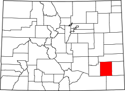
Location within Bent County and Colorado
Usa edcp location map.svg
Red pog.svg
Caddoa
Caddoa (the United States)
Coordinates: 38°02′52″N102°57′58″W / 38.0478°N 102.9660°W / 38.0478; -102.9660
Country United States
State Colorado
County Bent
Elevation
[1]
3,881 ft (1,183 m)
Time zone UTC-7 (MST)
  Summer (DST) UTC-6 (MDT)
ZIP Code
Hasty CO 81044 [2]

Caddoa is an extinct town located in Bent County, Colorado, United States. The community takes its name from nearby Caddoa Creek. [3]

Contents

History

The Caddoa post office operated from November 7, 1881, until March 7, 1958. [4] [5] The U.S. Post Office at Hasty (ZIP Code 81044) now serves Caddoa postal addresses. [2]

Caddoa District, from the construction of John Martin Reservoir, moved to Caddoa from the Tucumcari District after the Conchas Project finished. [6]

Notable people

See also

Related Research Articles

<span class="mw-page-title-main">Byers, Colorado</span> Census Designated Place in Colorado, United States

Byers is an unincorporated town, a post office, and a census-designated place (CDP) located in and governed by Arapahoe County, Colorado, United States. The CDP is a part of the Denver–Aurora–Lakewood, CO Metropolitan Statistical Area. The Byers post office has the ZIP Code 80103. At the United States Census 2020, the population of the Byers CDP was 1,322.

<span class="mw-page-title-main">Hotchkiss, Colorado</span> Town in Colorado, United States

Hotchkiss is a statutory town in Delta County, Colorado, United States. The population was 875 at the 2020 census.

<span class="mw-page-title-main">Louviers, Colorado</span> Census Designated Place in Colorado, United States

Louviers is an unincorporated town, a post office, and a census-designated place (CDP) located in and governed by Douglas County, Colorado, United States. The CDP is a part of the Denver–Aurora–Lakewood, CO Metropolitan Statistical Area. The Louviers post office has the ZIP Code 80131. At the United States Census 2020, the population of the Louviers CDP was 293.

<span class="mw-page-title-main">Sedalia, Colorado</span> Census Designated Place in Colorado, United States

Sedalia is an unincorporated town, a post office, and a census-designated place (CDP) located in and governed by Douglas County, Colorado, United States. The CDP is a part of the Denver–Aurora–Lakewood, CO Metropolitan Statistical Area. The Sedalia post office has the ZIP Code 80135. At the United States Census 2020, the population of the Sedalia CDP was 177.

<span class="mw-page-title-main">Edwards, Colorado</span> Census Designated Place in Colorado, United States

Edwards is an unincorporated town, a post office, and a census-designated place (CDP) located in and governed by Eagle County, Colorado, United States. Edwards is the principal town of the Edwards, CO Micropolitan Statistical Area. The Edwards post office has the ZIP Code 81632. At the United States Census 2020, the population of the Edwards CDP was 11,246. The Edwards Metropolitan District provides services.

<span class="mw-page-title-main">Kittredge, Colorado</span> Census Designated Place in Colorado, United States

Kittredge is an unincorporated town, a post office, and a census-designated place (CDP) located in and governed by Jefferson County, Colorado, United States. The CDP is a part of the Denver–Aurora–Lakewood, CO Metropolitan Statistical Area. The Kittredge post office has the ZIP code 80457. At the United States Census 2020, the population of the Kittredge CDP was 1,308.

<span class="mw-page-title-main">Atwood, Colorado</span> Census Designated Place in Colorado, United States

Atwood is an unincorporated town, a post office, and a census-designated place (CDP) located in and governed by Logan County, Colorado, United States. The CDP is a part of the Sterling, CO Micropolitan Statistical Area. The Atwood post office has the ZIP Code 80722. At the United States Census 2020, the population of the Atwood CDP was 138.

<span class="mw-page-title-main">Heeney, Colorado</span> Census Designated Place in Colorado, United States

Heeney is an unincorporated community and a census-designated place (CDP) located in and governed by Summit County, Colorado, United States. The CDP is a part of the Breckenridge, CO Micropolitan Statistical Area. The population of the Heeney CDP was 74 at the United States Census 2020. The Silverthorne post office (Zip Code 80498) serves Heeney postal addresses.

<span class="mw-page-title-main">Divide, Colorado</span> Census Designated Place in Colorado, United States

Divide is an unincorporated town, a post office, and a census-designated place (CDP) located in and governed by Teller County, Colorado, United States. The CDP is a part of the Colorado Springs, CO Metropolitan Statistical Area. The Divide post office has the ZIP Code 80814. At the United States Census 2020, the population of the Divide CDP was 143.

<span class="mw-page-title-main">Bristol, Colorado</span> Unincorporated community in Prowers County, Colorado, United States

Bristol is an unincorporated community in Prowers County, Colorado, United States. The U.S. Post Office at Holly now serves Bristol postal addresses.

<span class="mw-page-title-main">Chromo, Colorado</span> Unincorporated community in State of Colorado, United States

Chromo is an unincorporated community and U.S. Post Office in Archuleta County, Colorado, United States. The Chromo Post Office has the ZIP Code 81128.

<span class="mw-page-title-main">Cope, Colorado</span> Census Designated Place in Colorado, United States

Cope is an unincorporated town, a post office, and a census-designated place (CDP) located in and governed by Washington County, Colorado, United States. The population was 53 at the 2020 census. The Cope post office has the ZIP Code 80812.

<span class="mw-page-title-main">Egnar, Colorado</span> Unincorporated community in San Midgel County, Colorado, United States

Egnar is an unincorporated community in San Miguel County, Colorado, United States. Egnar has a U.S. Post Office with the ZIP Code 81325.

<span class="mw-page-title-main">Hasty, Colorado</span> Census Designated Place in Colorado, United States

Hasty is an unincorporated town in Bent County, Colorado, United States.

<span class="mw-page-title-main">Hesperus, Colorado</span> Unincorporated community in La Plata County, Colorado, United States

Hesperus is an unincorporated community and a U.S. Post Office in La Plata County, Colorado, United States. The Hesperus Post Office has the ZIP Code 81326.

<span class="mw-page-title-main">McClave, Colorado</span> Census Designated Place in Colorado, United States

McClave is an unincorporated community in Bent County, Colorado, United States. The population was 725 at the 2020 census.

<span class="mw-page-title-main">McCoy, Colorado</span> Census Designated Place in Colorado, United States

McCoy is an unincorporated town, a census-designated place (CDP), and a post office located in and governed by Eagle County, Colorado, United States. The CDP is a part of the Edwards, CO Micropolitan Statistical Area. The McCoy post office has the ZIP Code 80463. At the United States Census 2020, the population of the McCoy CDP was 30.

<span class="mw-page-title-main">Weldona, Colorado</span> Census Designated Place in Colorado, United States

Weldona is an unincorporated town, a post office, and a census-designated place (CDP) located in and governed by Morgan County, Colorado, United States. The CDP is a part of the Fort Morgan, CO Micropolitan Statistical Area. The Weldona post office has the ZIP Code 80653. At the United States Census 2020, the population of the Weldona CDP was 113.

<span class="mw-page-title-main">Wetmore, Colorado</span> Unincorporated community in Custer County, Colorado, United States

Wetmore is an unincorporated community and a U.S. Post Office located in Custer County, Colorado, United States.

Boyero is an unincorporated community in Lincoln County, Colorado, United States. The U.S. Post Office at Hugo now serves Boyero postal addresses.

References

  1. "US Board on Geographic Names". United States Geological Survey. September 12, 2023. Retrieved January 31, 2008.
  2. 1 2 "ZIP Code Lookup". United States Postal Service. January 3, 2007. Archived from the original (JavaScript/HTML) on September 3, 2007. Retrieved January 3, 2007.
  3. Dawson, John Frank (1954). Place names in Colorado: why 700 communities were so named, 150 of Spanish or Indian origin. Denver, CO: The J. Frank Dawson Publishing Co. p. 12.
  4. Bauer, William H.; Ozment, James L.; Willard, John H. (1990). Colorado Post Offices 1859–1989. Golden, Colorado: Colorado Railroad Historical Foundation. ISBN   0-918654-42-4.
  5. "Post offices". Jim Forte Postal History. Archived from the original on March 6, 2016. Retrieved June 24, 2016.
  6. "The History of the Albuquerque District". U.S. Army Corps of Engineers. Retrieved September 17, 2021.
  7. [ dead link ]
  8. "Boggsville". coloradoencyclopedia.org. November 5, 2015. Retrieved March 3, 2020.
  9. Cullum 1940, p. 462.
  10. Hager 2015, p. 2590.

Bibliography