John Wesley Prowers

Last updated • 11 min readFrom Wikipedia, The Free Encyclopedia
John Wesley Prowers
John Wesley Prowers (1838-1884).png
Born(1838-01-29)January 29, 1838
DiedFebruary 14, 1884(1884-02-14) (aged 46)
NationalityAmerican
Occupation(s)Trader, cattle-rancher, businessman, legislator
Spouse Amache Prowers
RelativesCheyenne Peace Chief Ochinee (father-in-law)

John Wesley Prowers (January 29, 1838 – February 14, 1884) was an American trader, cattle rancher, legislator, and businessman in the territory and state of Colorado. Married to Amache Prowers, a Cheyenne woman, his father-in-law was a Cheyenne chief who negotiated for peace and was killed during the Sand Creek massacre.

Contents

He began his career as a trader when he was eighteen years of age. After several years, he began buying cattle, the first man to drive cattle westward to Colorado. He was among the first white men to settle in southeastern Colorado. Known as the cattle baron of the Arkansas (River Valley), he was the first known person to introduce Hereford cattle to Colorado and the first cattle rancher in the area. He raised horses and sheep and operated a farm, which supplied Fort Lyon.

The Prowers House—which operated as a stagecoach station, general store, school, county office, and hotel—is one of the two Boggsville properties listed on the National Register of Historic Places. After the railroads came to the area, he moved to Las Animas and established a store, helped found a bank, and, with Charles Goodnight, co-founded a meat packing plant.

Early life

Prowers was born on January 29, 1838, near Westport, Missouri. [1] [2] [lower-alpha 1] As a young boy, he acquired a stepfather when his mother married John Vogil, who was hard on his stepson. Prowers spent just 13 months in the public schools. [1]

Career

Early career

A sketch of Bent's New Fort made in 1859 by Daniel Jenks who traveled to Colorado Territory in search of gold. Photo courtesy Library of Congress, Prints and Photographs Department. Bent's New Fort.jpg
A sketch of Bent's New Fort made in 1859 by Daniel Jenks who traveled to Colorado Territory in search of gold. Photo courtesy Library of Congress, Prints and Photographs Department.

When he was eighteen years of age, he was hired by Robert Miller who was an agent for Cheyenne, Arapaho, Kiowas, Comanche, and Apache tribes of the upper Arkansas area. They traveled from Westport, Missouri to Bent's Fort in what is now Colorado. Their wagon contained annuity goods—sugar, oatmeal, bacon, salt, beans, coffee, cornmeal, and other goods—which Miller and Prowers passed out to Native Americans who came to the fort. [1] [lower-alpha 2] Bent's Fort was a trading post where Native Americans traded buffalo robes and mountain men traded beaver skins for goods. Their customers included French-Canadians and Mexicans. [1] He worked at Bent's Fort for seven years, from 1856 to 1863, as a trader who led wagon trains to and from Missouri, returning with supplies for Bent's Fort. From 1865 to 1871, he delivered government supplies from Leavenworth, Kansas, to Fort Union. He also delivered supplies to Fort Laramie. [1] [4] He learned the Cheyenne language and was sometimes called upon to act as an interpreter. Respected by Native Americans and whites, he often provided background information about the lifestyle and issues of the indigenous people of Colorado to help whites understand their perspectives. [5]

Pioneer and Sand Creek massacre

When Prowers began to settle in what is now southeastern Colorado, there were very few white settlers and they were isolated from one another. [1] Albert G. Boone, the grandson of Daniel Boone and an Indian agent for the Cheyenne and Arapaho, lived 80 miles west of Fort Lyon and helped negotiate the Treaty of Fort Wise (later renamed Fort Lyon) in 1861. [1] [6] William Bent's Bent's Old Fort, established in 1833, was a stagecoach station, trading post, and a meeting place for people of Mexican, Native American, and European-American descent. [1] Robison Malory Moore, husband of William Bent's daughter, Mary, settled at the mouth of the Purgatoire River in 1860. [1] [7]

Delegation Of Cheyenne and Arapaho Chiefs at Camp Weld on September 28, 1864 Portrait of Black Kettle or Moke-Tao-To%3F and Delegation Of Cheyenne and Arapaho Chiefs 28 SEP 1864.jpg
Delegation Of Cheyenne and Arapaho Chiefs at Camp Weld on September 28, 1864

Over time, as more white people moved into what is now Colorado, relations between the Plains Indians and the whites became increasingly hostile. Cheyenne and Arapaho leaders did not understand the cultural ways and perspectives of the whites. [1] In 1864, Chief Black Kettle and Chief Ochinee (One-Eye) met with Governor John Evans and Colonel John Chivington. Although they did not have a formal treaty, they believed that they had an agreement for peace and complied with their requirements for peace, including arriving at Fort Lyon to enter into discussion with Major Wynkoop, who was replaced by the time they arrived by Major Anthony. Anthony supported their goal for peace and the Cheyenne leaders explained that the young men were planning on leaving on a buffalo hunt. The Cheyenne were told that they would be safe if they stayed at their Sand Creek encampment. [1] Soldiers from the fort arrived at the Prowers home and held the family and ranch hands hostages for 2 and a half days before the Sand Creek massacre on November 29, 1864, [1] in which Chief Ochinee and 160 people from the village, mostly women and children, died. [8]

Rancher and farmer

Hereford cattle Hereford cattle.jpg
Hereford cattle

The first man to drive cattle to the west, [3] Prowers began purchasing cattle in 1861, first shorthorn cattle and then Hereford cattle, who better survived the Colorado winters. He drove them to Colorado during his wagon train trips. [1] [lower-alpha 3] He was considered the first [9] and largest rancher in the area. [10] In 1863, he increased his land holdings when he bought land across from Fort Lyons. [5] Prowers' wife Amache, their two oldest daughters, and Amache's mother each received reparations by the United States government in the form of 640 acres of land along the Arkansas River. Amache used her land to expand her family's cattle ranch. [8] [11] [12] [lower-alpha 4] He purchased some of his land for his cattle ranching from the half-Native American children who received war reparations following the Sand Creek massacre (1864) and from local whites. [13]

The Prowers also raised sheep and horses and operated a farm. Fort Lyon bought nearly all the produce that the farm produced. [14] Tarbox Ditch, a seven-mile irrigation ditch that served 1,000 acres, was utilized by the Prowers farm, as well as the Boggs and Robert Bent farms. [14] Due to the irrigation, the three farms grew potatoes, corn, wheat, [15] alfalfa, and vegetables. [2] He contracted with the United States government to provide large quantities of hay. [3]

The Atchison, Topeka and Santa Fe Railway (AT&SF) came to Colorado in 1873 and its tracks ran along a border of the Prowers ranch. A train station was established at Granada, Colorado. Cattle was then shipped via train, rather than having to be driven to stockyards. [13] By 1876, Prowers, known as the cattle baron of the Arkansas (Arkansas River Valley), and Charles Goodnight established a meatpacking plant in Las Animas. [16] The Prowers had 15,000 head of cattle and had acquired more land so that they had 30 miles of waterfront alongside the Arkansas River by 1881. [13] [lower-alpha 5] [lower-alpha 6] They had 70,000 head of cattle at one fall roundup. [2]

Businessman

After living first at Bent's Fort, John and his wife operated a stagecoach station at their home in Caddoa, Colorado. [14] During the winter, they boarded mules and horses for Fort Lyon and in the summer grew vegetables for the military. They also sold horses and livestock to the fort. In the spring of 1867, a flood of the Arkansas River nearly destroyed the fort. It was moved 20 miles west and the Prowers moved to be closer to the new location. [2]

In 1867, the Prowers family established a two-story, 14-room house in Boggsville, Colorado. [2] [14] The U-shaped building was the site of a stagecoach station, school, and general store. They raised cattle there. [3] [14] After 1870, Bent County's county office was located in the Prowers house, which served as Boggsville's town center. About that time, a school was established near the Prowers house. [14] Established in 1869 with 21 students, it was the first public school in southeastern Colorado. [2] Kit Carson was a neighbor there. [14]

Prowers House in Boggsville, Colorado Prowers House in Boggsville.JPG
Prowers House in Boggsville, Colorado

Located on the Purgatory branch of the Santa Fe Trail, the stagecoach station provided meals for travelers, while the stagecoach horses were traded for fresh horses. Officers at For Lyon were guests at the Prowers House. [2] Parties and dances were held in Boggsville, which drew settlers and cowboys from a 50-mile radius. [2] The Prowers house became a property on the Boggsville Historic Site in 1985, [14] and it was listed on the National Register of Historic Places the following year. [2] It is a certified site of the Santa Fe Trail. [18]

After the Atchison Topeka & Santa Fe Railway and the Kansas Pacific Railway established rail service into southeastern Colorado in 1873, [2] The Prowers moved to the new town of Las Animas, Colorado, in 1873 [2] [14] or 1874, [3] where they lived and operated a large general store. John helped found the Bent County Bank and established the commission house of Prowers & Hough, [2] [14] which received goods delivered to him in Las Animas and he had delivered to merchants in southeastern Colorado, New Mexico, and Arizona—until railroad service extended deeper into Colorado. [1]

Politician

Bent County became a county within Colorado in February 1870 and Las Animas was the county seat. Prowers was elected the first county commissioner and Boggsville was made the county seat in November. [1] A Democrat, [3] Prowers served in the territorial legislature in 1873 and the state legislature in 1880; [13] [4] Colorado became a state in 1876. [9] He was defeated when he ran for lieutenant governor, with Hon. J.B. Grant on the ticket for governor. [3]

Personal life

Prowers met a Cheyenne girl, Amache Ochinee, the daughter of a Cheyenne sub-chief Ochinee and later gained acceptance from her father to marry her. The 15 year-old Amache and Prowers were married in the Indian Territory near Camp Supply in 1861. They started their married life at Bent's Fort in the commissary building. [1]

Big Timbers along the Arkansas River. An illustration from Richard Irving Dodge (1883). Our Wild Indians; Thirty-three Years' Personal Experience Among the Red Men of the Great West Big Timbers.jpg
Big Timbers along the Arkansas River. An illustration from Richard Irving Dodge (1883). Our Wild Indians; Thirty-three Years' Personal Experience Among the Red Men of the Great West

During his winter 1862 trip to Missouri, Prowers left Amache with his aunt in Westport and their first child, Mary, was born there on July 18, 1863. Prowers picked up his family a few months later for the two-month return trip to Colorado. They settled with their baby daughter at a cattle ranch with three stone buildings that Prowers established on Caddoa Creek in the area of Big Timbers. [1] [lower-alpha 7] Mary married A.D. Hudnall and had three children. Their second child, Katherine, married W.A. Haws and had two children. Inez married Glen O. Comstock and had two children. The only surviving son, John Wesley, Jr. was followed by George, who died at age eleven. Leona, the wife of T.H. Marshall, died at 20 years of age. Ida married Louis F. Horton. Amy had not married by 1899. [3] The children were educated in Colorado at Rice Institute in Trinidad, at local schools, and Wolfe Hall in Denver, [1] and then sent to Lexington and Independence, Missouri, to for higher level schooling or college. [3] [1] For instance, John Wesley, Jr. went to Lexington, where he was educated at Wentworth Military Academy between 1883 and 1888, from ages 13 to 18. [3]

When the family lived in Boggsville, Native American tribes camped nearby as they visited their relatives, like Amache, who were married to white men. [2] He is welcoming, accommodating and generous with Amache's Cheyenne family members, who honored and respected him. [1] Settlers stayed at Boggsville in September 1868 when renegade Cheyenne warriors stole and killed livestock and killed one person. [2] [lower-alpha 8] The Cheyenne were keenly aware that the construction of railway lines in Colorado meant an end to their way of life. Prowers averted an attack by the Cheyenne on Las Animas, where there was a railway station. [1]

In 1880, with an intention to increase the wildlife in the area, Prowers shipped in white-tail deer—three does and two bucks—and turned them loose near his ranch. As of 1945, white-tailed deer were found in New Mexico, near Trinidad on Fishers Peak, and near where they were originally released along the Arkansas River. An earlier attempt by Prowers to introduce eight dozen prairie chickens was not successful, but his friends Luke Cahill and Judge M. Robinson were successful at introducing bobwhite quail in the area. [1]

Death and legacy

In late 1883 [5] or 1884, Prowers was seriously ill and went to Kansas City, Missouri, for medical treatment. He died there at the home of his sister Mrs. John Simpson Hough on February 14, 1884, [1] [5] leaving an estate of $750,000 (equivalent to $25,433,333in 2023). [2] He was buried at Las Animas cemetery, as was Amache, who died in Boston. [1] Prowers County, Colorado, was named after him. [4] [9]

Notes

  1. His birth year is also (but rarely) stated as 1839. [3]
  2. William Bent it said to have led of the wagon train. [3]
  3. He settled on the Hereford cattle after experimenting with Kurry cattle from England and Black Angus cattle from Scotland. [2]
  4. Although land owned by American women went to their husbands if they were married, the treaty that Amache and her female family members were subject to meant that they owned the land gained through reparations. [12]
  5. They are said to have amassed up to 50,000 cattle and were major landowners in the Big Timbers area of Colorado, [17] which was the hunting and winter campground for Native American tribes. [13]
  6. In the winters of 1885–1886 and 1886–1887, "intense blizzards" resulted in a tremendous loss of cattle in Colorado, nearly wiping out the cattle industry. By that time, John Wesley Prowers had died and his wife and son ran the cattle ranch. [13]
  7. The three buildings were erected when the Caddo tribe was relocated from Texas, but decided not to move there. [1]
  8. This was at a time when Native Americans had made treaties that they would not range across their old hunting ground and campsites in exchange for food upon which they would need to survive. But, Native Americans began to starve because they did not receive enough food to survive.

Related Research Articles

<span class="mw-page-title-main">Bent County, Colorado</span> County in Colorado, United States

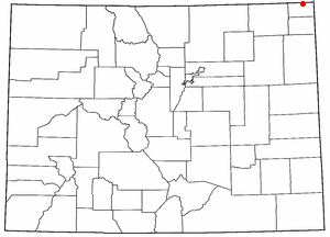
Bent County is a county located in the U.S. state of Colorado. As of the 2020 census, the population was 5,650. The county seat and only incorporated municipality is Las Animas. The county is named in honor of frontier trader William Bent.

<span class="mw-page-title-main">Las Animas, Colorado</span> City in Colorado, United States

Las Animas is the statutory city that is the county seat, the most populous community, and the only incorporated municipality in Bent County, Colorado, United States. The city population was 2,300 at the 2020 United States Census. Las Animas is located on the Arkansas River, just west of its confluence with the Purgatoire River, in southeast Colorado east of Pueblo, near the historic Bent's Fort.

<span class="mw-page-title-main">Sand Creek massacre</span> 1864 killing of Cheyenne and Arapaho people by US troops during the American Indian Wars

The Sand Creek massacre was a massacre of Cheyenne and Arapaho people by the U.S. Army in the American Indian Wars that occurred on November 29, 1864, when a 675-man force of the Third Colorado Cavalry under the command of U.S. Volunteers Colonel John Chivington attacked and destroyed a village of Cheyenne and Arapaho people in southeastern Colorado Territory, killing and mutilating an estimated 69 to over 600 Native American people. Chivington claimed 500 to 600 warriors were killed. However, most sources estimate around 150 people were killed, about two-thirds of whom were women and children. The location has been designated the Sand Creek Massacre National Historic Site and is administered by the National Park Service. The massacre is considered part of a series of events known as the Colorado Wars.

<span class="mw-page-title-main">Black Kettle</span> Leader of the Southern Cheyenne

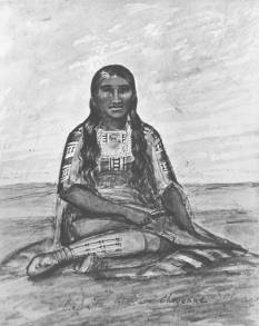
Black Kettle was a prominent leader of the Southern Cheyenne during the American Indian Wars. Born to the Northern Só'taeo'o / Só'taétaneo'o band of the Northern Cheyenne in the Black Hills of present-day South Dakota, he later married into the Wotápio / Wutapai band of the Southern Cheyenne.

<span class="mw-page-title-main">John Evans (Colorado politician)</span> American politician

John Evans was an American politician, physician, founder of various hospitals and medical associations, railroad promoter, governor of the territory of Colorado, and namesake of Evanston, Illinois; Evans, Colorado; and formerly Mount Evans, Colorado.

<span class="mw-page-title-main">Colorado War</span> 19th-century armed conflict of the American Indian Wars

The Colorado War was an Indian War fought in 1864 and 1865 between the Southern Cheyenne, Arapaho, and allied Brulé and Oglala Sioux peoples versus the U.S. Army, Colorado militia, and white settlers in Colorado Territory and adjacent regions. The Kiowa and the Comanche played a minor role in actions that occurred in the southern part of the Territory along the Arkansas River. The Cheyenne, Arapaho, and Sioux played the major role in actions that occurred north of the Arkansas River and along the South Platte River, the Great Platte River Road, and the eastern portion of the Overland Trail. The United States government and Colorado Territory authorities participated through the 1st Colorado Cavalry Regiment, often called the Colorado volunteers. The war was centered on the Colorado Eastern Plains, extending eastward into Kansas and Nebraska.

<span class="mw-page-title-main">William Bent</span> American rancher and frontier trader (1809–1869)

William Wells Bent was a frontier trader and rancher in the American West, with forts in Colorado. He also acted as a mediator among the Cheyenne Nation, other Native American tribes and the expanding United States. With his brothers, Bent established a trade business along the Santa Fe Trail. In the early 1830s Bent built an adobe fort, called Bent's Fort, along the Arkansas River in present-day Colorado. Furs, horses and other goods were traded for food and other household goods by travelers along the Santa Fe trail, fur-trappers, and local Mexican and Native American people. Bent negotiated a peace among the many Plains tribes north and south of the Arkansas River, as well as between the Native American and the United States government.

<span class="mw-page-title-main">Fort Lyon</span> United States historic place in Colorado

Fort Lyon was composed of two 19th-century military fort complexes in southeastern Colorado. The initial fort, also called Fort Wise, operated from 1860 to 1867. After a flood in 1866, a new fort was built near Las Animas, Colorado, which operated as a military post until 1897.

Colorado's 4th congressional district is a congressional district in the U.S. state of Colorado. Located in the eastern part of the state, the district encompasses most of the rural Eastern Plains as well as portions of the Colorado Front Range including Loveland, Highlands Ranch, Castle Rock, and Parker.

<span class="mw-page-title-main">Fort Lyon National Cemetery</span> Veterans cemetery in Bent County, Colorado

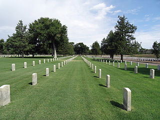
Fort Lyon National Cemetery is a United States National Cemetery located near the city of Las Animas in Bent County, Colorado. It encompasses 51.9 acres and as of 2014 had 2,556 interments. It is administered by the Fort Logan National Cemetery in Denver County, Colorado.

<span class="mw-page-title-main">Caddoa, Colorado</span> Unincorporated community in State of Colorado, United States

Caddoa is an extinct town located in Bent County, Colorado, United States. The community takes its name from nearby Caddoa Creek.

<span class="mw-page-title-main">Chief Niwot</span> Arapho leader

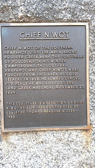
Chief Niwot or Left Hand(-ed) was a Southern Arapaho chief, diplomat, and interpreter who negotiated for peace between white settlers and the Cheyenne and Arapaho tribes during the Pike's Peak Gold Rush and Colorado War.

The Santa Fe Trail Scenic and Historic Byway is a 188-mile (303 km) National Scenic Byway and Colorado Scenic and Historic Byway located in Prowers, Bent, Otero, and Las Animas counties, Colorado, USA. The byway follows the Santa Fe National Historic Trail through southeastern Colorado and connects to the 381-mile (613 km) Santa Fe Trail Scenic Byway in New Mexico at Raton Pass, a National Historic Landmark at elevation 7,834 feet (2,388 m). The byway visits Amache National Historic Site and Bent's Old Fort National Historic Site, both National Historic Landmarks, and winds between the Spanish Peaks and Raton Mesa, both National Natural Landmarks.

<span class="mw-page-title-main">Boggsville, Colorado</span> Extinct town in State of Colorado, United States

Boggsville is an extinct town located in Bent County, Colorado, United States. The town was located near the Purgatoire River about 3 miles (4.8 km) above the Purgatoire's confluence with the Arkansas River. It was established in 1866. The surviving structures are among the earliest examples of Territorial architecture in Colorado. Boggsville was the last home of frontiersman Kit Carson before his death in 1868 at Fort Lyon. The U.S. Post Office at Las Animas now serves Boggsville postal addresses.

<span class="mw-page-title-main">Owl Woman</span> Cheyenne woman (d. 1847)

Owl Woman was a Cheyenne woman., a daughter of White Thunder, a well-respected medicine man of the Cheyenne tribe. She was married to an Anglo-American trader named William Bent, with whom she had four children. Owl Woman was inducted into the Colorado Women's Hall of Fame for her role in managing relations between Native American tribes and the Anglo-American men.

<span class="mw-page-title-main">Battle of Julesburg</span>

The Battle of Julesburg took place on January 7, 1865, near Julesburg, Colorado between 1,000 Cheyenne, Arapaho, and Lakota Indians and about 60 soldiers of the U.S. army and 40 to 50 civilians. The Indians defeated the soldiers and over the next few weeks plundered ranches and stagecoach stations up and down the South Platte River valley.

<span class="mw-page-title-main">Bent's New Fort</span> Archaeological site in Colorado, United States

Bent's New Fort was a historic fort and trading post along the banks of the Arkansas River in what is now Bent County, Colorado, about nine miles west of Lamar, on the Mountain Route branch of the Santa Fe Trail. William Bent operated a trading post with limited success at the site and in 1860 leased the fort to the United States government, which operated it as a military outpost until 1867. In 1862, it was named Fort Lyon. The fort was abandoned after a flood of the Arkansas River in 1867.

<span class="mw-page-title-main">Amache Prowers</span> Native American activist, advocate and cattle rancher

Amache Ochinee Prowers, also known as Walking Woman, was a Native American activist, advocate, cattle rancher, and operator of a store on the Santa Fe Trail. Her father was a Cheyenne peace chief who was killed during the Sand Creek massacre on November 29, 1864, after which she became a mediator between Colorado territorial settlers, Mexicans, and Native Americans during the 1860s and 1870s. She was inducted into the Colorado Women's Hall of Fame in 2018.

<span class="mw-page-title-main">Ochinee</span>

Ochinee, also known as Lone Bear and One-Eye, was a Native American Peace Chief of the Cheyenne tribe. He was the father of Amache Prowers, a tradeswoman, advocate and leader among the Southern Cheyenne. Ochinee, who had worked to create peace for the Cheyenne, died during the Sand Creek massacre on November 29, 1864.

<span class="mw-page-title-main">Friday (Arapaho chief)</span> Chief and interpreter of Northern Arapaho

Friday (Arapaho: Teenokuhu or Warshinun, also known as Friday Fitzpatrick, was an Arapaho leader and interpreter in the mid to late 1800s. When he was around the age of eight, he was separated from his band and was taken in by a white trapper. During the next seven years, he was schooled in St. Louis, Missouri and went on trapping expeditions with his informally adopted father, Thomas Fitzpatrick. After he was recognized by his mother during an encounter with the Arapaho, he returned to the tribe.

References

  1. 1 2 3 4 5 6 7 8 9 10 11 12 13 14 15 16 17 18 19 20 21 22 23 24 25 Hudnall, Mary Prowers (November 1945). "Early History of Bent County" (PDF). The Colorado Magazine. Vol. XXII, no. 6. The State Historical Society of Colorado. Retrieved March 3, 2020.
  2. 1 2 3 4 5 6 7 8 9 10 11 12 13 14 15 16 McKenzie, William H. (February 7, 1986). "National Register of Historic Places Inventoryu - Nomination Form: Boggsville". National Park Service. Retrieved March 2, 2020.
  3. 1 2 3 4 5 6 7 8 9 10 11 Portrait and Biographical Record of the State of Colorado. Chapman Publishing Company. 1899. pp.  439.
  4. 1 2 3 Aiken, Charles Curry; Kane, Joseph Nathan (2012-12-21). The American Counties: Origins of County Names, Dates of Creation, Area, and Population Data, 1950-2010. Scarecrow Press. p. 251. ISBN   978-0-8108-8762-6.
  5. 1 2 3 4 Thrapp, Dan L. (1991-06-01). Encyclopedia of Frontier Biography: P-Z. University of Nebraska Press. p. 1177. ISBN   978-0-8032-9420-2.
  6. Abbott, Carl (2013-05-15). Colorado: A History of the Centennial State, Fifth Edition. University Press of Colorado. pp. PT95. ISBN   978-1-4571-8125-2.
  7. Portrait and Biographical Record of the State of Colorado: Containing Portraits and Biographies of Many Well Known Citizens of the Past and Present. Chapman Publishing Company. 1899. pp.  510.
  8. 1 2 "Amache Prowers". Colorado Women's Hall of Fame. Retrieved March 1, 2020.
  9. 1 2 3 "Prowers County, Colorado". Advisory Council on Historic Preservation. Retrieved March 3, 2020.
  10. "Descendants of Amache visit Boggsville". BC Democrat Online - Las Animas, CO. August 14, 2017. Archived from the original on March 2, 2020. Retrieved March 3, 2020.
  11. Garrison, Robert (June 30, 2009). "Wife of John Prowers namesake of Amache Studio" . Retrieved March 2, 2020.
  12. 1 2 Bear, Carson (August 15, 2018). "Archaeology Reveals the Hidden History of Amache Ochinee Prowers - National Trust for Historic Preservation". Saving Places, National Trust for Historic Preservation. Retrieved March 1, 2020.
  13. 1 2 3 4 5 6 "Prowers County". coloradoencyclopedia.org. November 15, 2016. Retrieved March 3, 2020.
  14. 1 2 3 4 5 6 7 8 9 10 "Boggsville". coloradoencyclopedia.org. November 5, 2015. Retrieved March 3, 2020.
  15. "Bent County". coloradoencyclopedia.org. April 17, 2015. Retrieved March 2, 2020.
  16. Campbell, Jeff C. (June 27, 2018). "The trail from Lonesome Dove, Part 3" . Retrieved March 3, 2020.
  17. From the Grave: A Roadside Guide to Colorado's Pioneer Cemeteries. Caxton Press. p. 287. ISBN   978-0-87004-565-3.
  18. "Boggsville". National Trust for Historic Preservation. Retrieved March 2, 2020.