The Pike's Peak Gold Rush was the boom in gold prospecting and mining in the Pike's Peak Country of western Kansas Territory and southwestern Nebraska Territory of the United States that began in July 1858 and lasted until roughly the creation of the Colorado Territory on February 28, 1861. An estimated 100,000 gold seekers took part in one of the greatest gold rushes in North American history.

Cheyenne County is a county located in the U.S. state of Colorado. The county population was 1,748 at 2020 census. The county seat is Cheyenne Wells.

The Smoky Hill River is a 575-mile (925 km) river in the central Great Plains of North America, running through Colorado and Kansas.

The Territory of Colorado was an organized incorporated territory of the United States that existed from February 28, 1861, until August 1, 1876, when it was admitted to the Union as the State of Colorado.

A "Fifty-Niner" is the term used for the gold seekers who streamed into the Pike's Peak Country of western Kansas Territory and southwestern Nebraska Territory in 1859. The discovery of placer gold deposits along the South Platte River at the foot of the Rocky Mountains in northwestern Kansas Territory by a party of miners led by William Greeneberry "Green" Russell in July 1858 precipitated the Pike's Peak Gold Rush.

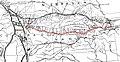
The Cherokee Trail was a historic overland trail through the present-day U.S. states of Oklahoma, Kansas, Colorado, and Wyoming that was used from the late 1840s up through the early 1890s. The route was established in 1849 by a wagon train headed to the gold fields in California. Among the members of the expedition were a group of Cherokee. When the train formed in Indian Territory, Lewis Evans of Evansville, Arkansas, was elected Captain. Thus, this expedition is sometimes written as the Evans/Cherokee Train. In 1850 four wagon trains turned west on the Laramie Plains, along Wyoming's southern border to Fort Bridger.

The Central Overland California and Pike's Peak Express Company was a stagecoach line that operated in the American West in the early 1860s, but it is most well known as the parent company of the Pony Express. It was formed as a subsidiary of the freighting company Russell, Majors, and Waddell, after the latter two partners bought out Russell's stage line, the Leavenworth and Pikes Peak Express Company. The stage line had made its first journey from Westport, Missouri, to Denver on March 9, 1859.

William Hepburn Russell (1812–1872) was a United States businessman. He was a partner, along with Alexander Majors and William B. Waddell, in the freighting firm Russell, Majors, and Waddell and the stagecoach company the Central Overland California and Pikes Peak Express Company which was the parent company of the Pony Express. His public life is one of numerous business ventures, some successful and some failed. While Russell, described as a good-looking man, lived the majority of his life on the edge on the western frontier, he was always more at home in the upper-class settings of the East coast.
The Butterfield Overland Despatch was a mail and freight service operating across the Great Plains of America in the 1860s.
The Central Overland Route was a transportation route from Salt Lake City, Utah south of the Great Salt Lake through the mountains of central Nevada to Carson City, Nevada. For a decade after 1859, until the first Transcontinental Railroad was completed in 1869, it served a vital role in the transport of emigrants, mail, freight, and passengers between California, Nevada, and Utah.
William Greeneberry "Green" Russell (1818–1877) was an American prospector and miner.

Old Colorado City, formerly Colorado City, was once a town, but it is now a neighborhood within the city of Colorado Springs, Colorado. Its commercial district was listed on the National Register of Historic Places in 1982. It was founded during the Pikes Peak Gold Rush of 1859 and was involved in the mining industry, both as a supply hub and as a gold ore processing center beginning in the 1890s. Residents of Colorado City worked at some of the 50 coal mines of the Colorado Springs area. It was briefly the capital of the Colorado Territory. For many years, Colorado Springs prohibited the use of alcohol within its border due to the lifestyle of Colorado City's opium dens, bordellos, and saloons. It is now a tourist area, with boutiques, art galleries, and restaurants.
Fort Morgan, first called Camp Tyler and Camp Wardwell, was established in the present-day city of Fort Morgan in Morgan County, Colorado as a U.S. military post in 1864. It operated until 1868. There is a historical marker in a city park in remembrance of its history.
The Trapper's Trail or Trappers' Trail is a north-south path along the eastern base of the Rocky Mountains that links the Great Platte River Road at Fort Laramie and the Santa Fe Trail at Bent's Old Fort. Along this path there were a number of trading posts, also called trading forts.
The Overland Trail was a stagecoach and wagon trail in the American West during the 19th century. While portions of the route had been used by explorers and trappers since the 1820s, the Overland Trail was most heavily used in the 1860s as a route alternative to the Oregon, California, and Mormon trails through central Wyoming. The Overland Trail was famously used by the Overland Stage Company owned by Ben Holladay to run mail and passengers to Salt Lake City, Utah, via stagecoaches in the early 1860s. Starting from Atchison, Kansas, the trail descended into Colorado before looping back up to southern Wyoming and rejoining the Oregon Trail at Fort Bridger. The stage line operated until 1869 when the completion of the First transcontinental railroad eliminated the need for mail service via stagecoach.
In the history of the American frontier, overland trails were built by pioneers throughout the 19th century and especially between 1829 and 1870 as an alternative to sea and railroad transport. These immigrants began to settle much of North America west of the Great Plains as part of the mass overland migrations of the mid-19th century. Settlers emigrating from the eastern United States were spurred by various motives, among them religious persecution and economic incentives, to move to destinations in the far west via routes including the Oregon, California, and Mormon Trails. After the end of the Mexican–American War in 1849, vast new American conquests again enticed mass immigration. Legislation like the Donation Land Claim Act and significant events like the California Gold Rush further lured people to travel overland to the west.

Southern Emigrant Trail, also known as the Gila Trail, the Kearny Trail, Southern Trail and the Butterfield Stage Trail, was a major land route for immigration into California from the eastern United States that followed the Santa Fe Trail to New Mexico during the California Gold Rush. Unlike the more northern routes, pioneer wagons could travel year round, mountain passes not being blocked by snows, however it had the disadvantage of summer heat and lack of water in the desert regions through which it passed in New Mexico Territory and the Colorado Desert of California. Subsequently, it was a route of travel and commerce between the eastern United States and California. Many herds of cattle and sheep were driven along this route and it was followed by the San Antonio-San Diego Mail Line in 1857–1858 and then the Butterfield Overland Mail from 1858–1861.
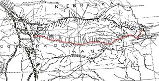
South Platte Trail was a historic trail that followed the southern side of South Platte River from Fort Kearny in Nebraska to Denver, Colorado. Plains Indians, such as the Cheyenne and the Arapaho, hunted in the lands around the South Platte River. They also traded at trading posts along the route, as did white travelers. Travelers included trappers, traders, explorers, the military, and those following the gold rush. The trail was also used by the Pony Express.
Fort Wicked was a ranch and stage station on the Overland Trail from 1864 to 1868 in present-day Merino, Colorado. A historical marker commemorating the ranch is located at US 6 and CR-2.5. The ranch itself was located near a ford of the South Platte River, near where US-6 now crosses over the river. It was one of the few places along the trail to Denver that withstood an attack by Native Americans in 1864. It was named Fort Wicked for the "bitter defence" made by Holon Godfrey.
Jimmy's Camp was a trading post established in 1833. The site is east of present-day Colorado Springs, Colorado on the southeast side of U.S. Route 24 and east of the junction with State Highway 94. Located along Trapper's Trail / Cherokee Trail, it was a rest stop for travelers and was known for its spring. Jimmy Camp was a ranch by 1870 and then a railway station on a spur of the Colorado and Southern Railway. After the ranch was owned by several individuals, it became part of the Banning Lewis Ranch. Now the land is an undeveloped park in Colorado Springs.