Taos Mountain Trail

Last updated
A historical marker memorializing the trail, located on County Road 520 in Huerfano County, Colorado. Taos Trail.JPG
A historical marker memorializing the trail, located on County Road 520 in Huerfano County, Colorado.

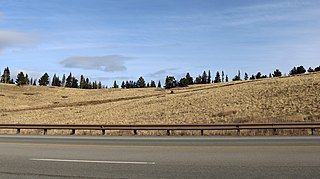
The Taos Mountain Trail was the historic pathway for trade and business exchanges between agrarian Taos (New Mexico) and the Great Plains (Colorado) from pre-history (1100 A.D.) through the Spanish Colonial period and into the time of the European and American presence. The Taos Mountain Trail, between northern New Mexico and southern Colorado, connected the high mountain traders and their trading partners north and south of the Sangre de Cristo Mountains. [1] Also called the Trapper's Trail, the pathway was only wide enough for people on foot or horses in single file, but it shortened a trip from Taos to the plains farther north from nearly two weeks to three days in good weather. The Taos Mountain Trail was also known as the Sangre de Cristo Trail and the Aztec Trail. [2]

Taos Pueblo pueblo

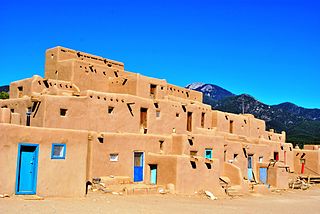
Taos Pueblo is an ancient pueblo belonging to a Taos-speaking (Tiwa) Native American tribe of Puebloan people. It lies about 1 mile (1.6 km) north of the modern city of Taos, New Mexico. The pueblos are considered to be one of the oldest continuously inhabited communities in the United States. This has been designated a UNESCO World Heritage Site.

New Mexico State of the United States of America

New Mexico is a state in the Southwestern region of the United States of America; its capital and cultural center is Santa Fe which was founded in 1610 as capital of Nuevo México, while its largest city is Albuquerque with its accompanying metropolitan area. It is one of the Mountain States and shares the Four Corners region with Utah, Colorado, and Arizona; its other neighboring states are Oklahoma to the northeast, Texas to the east-southeast, and the Mexican states of Chihuahua to the south and Sonora to the southwest. With a population around two million, New Mexico is the 36th state by population. With a total area of 121,590 sq mi (314,900 km2), it is the fifth-largest and sixth-least densely populated of the 50 states. Due to their geographic locations, northern and eastern New Mexico exhibit a colder, alpine climate, while western and southern New Mexico exhibit a warmer, arid climate.

Great Plains broad expanse of flat land west of the Mississippi River and east of the Rocky Mountains in the United States and Canada

The Great Plains is the broad expanse of flat land, much of it covered in prairie, steppe, and grassland, that lies west of the Mississippi River tallgrass prairie in the United States and east of the Rocky Mountains in the U.S. and Canada. It embraces:

Contents

In the early period (1100 AD to 1500 AD), the trail connected the Pueblos of northern New Mexico to the Plains Indians—Ute, Arapaho, Apache, Cheyenne and Kiowa. [3] The sedentary Pueblo people traded crops of corn, squash, melons, and beans to the migratory Plains tribes in exchange for buffalo meat, hides and other goods.

Ute people Native Americans of the Ute tribe and culture

Ute people are Native Americans of the Ute tribe and culture and are among the Great Basin classification of Indigenous People. They have lived in the regions of present-day Utah and Colorado for centuries, hunting, fishing and gathering food. In addition to their home regions within Colorado and Utah, their hunting grounds extended into Wyoming, Oklahoma, and New Mexico. They had sacred grounds outside of their home domain that were also visited seasonally. Spiritual and ceremonial practices were observed by the Utes.

Arapaho tribe of Native Americans historically living on the plains of Colorado and Wyoming

The Arapaho are a tribe of Native Americans historically living on the plains of Colorado and Wyoming. They were close allies of the Cheyenne tribe and loosely aligned with the Lakota and Dakota. The Arapaho language, Hinónoʼeitíít, is an Algonquian language closely related to Gros Ventre (Ahe/A'ananin), whose people are considered to have separated from the Arapaho at an early time. The Blackfeet and Cheyenne also speak Algonquian languages, but theirs are quite different from Arapaho.

The Apache are a group of culturally related Native American tribes in the Southwestern United States, which include the Chiricahua, Jicarilla, Lipan, Mescalero, Salinero, Plains and Western Apache. Distant cousins of the Apache are the Navajo, with which they share the Southern Athabaskan languages. There are Apache communities in Oklahoma, Texas, and reservations in Arizona and New Mexico. Apache people have moved throughout the United States and elsewhere, including urban centers. The Apache Nations are politically autonomous, speak several different languages and have distinct cultures.

Legend has it that traders from far away Tenochtitlan, the Aztec capital (near modern Mexico City) used the trail leaving cairns of stones to mark the way. Although there is a great deal of evidence that the people of MesoAmerica traded North into present day Colorado (Mesa Verde), [4] the only evidence for Tarahumaran penetration into Colorado was the discovery of plant of Mexican origin at the top of the pass by William A. Weber, professor emeritus of Botany. Charlie Charlefue, a Huerfano Valley resident, also placed a group of Tarahumara Indians in the area prior to American contact [5]

Tenochtitlan former city-state in the Valley of Mexico

Tenochtitlan was a large Mexica city-state in what is now the center of Mexico City. Founded on June 20, 1325, the city was built on an island in what was then Lake Texcoco in the Valley of Mexico. The city was the capital of the expanding Aztec Empire in the 15th century until it was captured by the Spanish in 1521.

Mexico City Capital in Mexico

Mexico City, or the City of Mexico, is the capital of Mexico and the most populous city in North America. Mexico City is one of the most important cultural and financial centres in the Americas. It is located in the Valley of Mexico, a large valley in the high plateaus in the center of Mexico, at an altitude of 2,240 meters (7,350 ft). The city has 16 boroughs.

Taos Pueblo was a trading center hosting fall and spring trade fairs. [6] This fair is mentioned as being in existence prior to and throughout the Spanish Colonial period. In good weather, the Taos Mountain Trail provided the pathway for travel from the eastern plains to the wide plateaus of the Taos Pueblo.

Trading companies (desiring furs and hides) determined that sending out men to trade with the Native American groups for the desired hides was more efficient than building trading posts and inviting the Native American people to visit. [7] The traders would obtain their goods from stores in Taos or Santa Fe then return to sell the hides obtained in trade with the Native American thus making the Taos Mountain Trail conduit more important. To aid the trade, Bent's Fort was built in 1833 [8] and El Pueblo Trading Post followed in 1842. [9] Traders headquartered in Bent's Fort and El Pueblo went out to trade with goods from Taos. The Taos Mountain Trail continued in use as it provided quick access to a settled community.

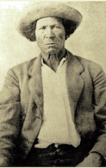
During the Mexican-American War, the people of Taos (Taoseños), both Native American and Spanish, revolted in January 1847 killing many Americans living in Taos including the American appointed governor Charles Bent. Survivors of the attack at nearby Turley’s Mill crossed the Taos Mountain Trail on foot in winter to spread the word of the revolt to El Pueblo Trading Post and Bent’s Fort. [10]

Indigenous peoples of the Americas Pre-Columbian inhabitants of North, Central, and South America and their descendants

The indigenous peoples of the Americas are the Pre-Columbian peoples of North, Central and South America and their descendants.

Charles Bent American politician

Charles Bent was appointed as the first civilian Governor of the newly acquired New Mexico Territory by military Governor Stephen Watts Kearny in September 1846.

During the railroad expansion era (1848-1853), the Taos Mountain Trail, also called the Sangre de Cristo Pass, was considered for a railway route. E.G. Beckwith was sent to survey the area in 1853. Richard Kern, a topographer and expeditionary artist, traveled with Beckwith to illustrate the land for the report. Although the trail was not chosen for the railroad as it was too steep, the report did provide documentation of the Taos Mountain Trail. [11]

Related Research Articles

Sangre de Cristo Mountains subrange of the Rocky Mountains in the US

The Sangre de Cristo Mountains are the southernmost subrange of the Rocky Mountains. They are located in southern Colorado and northern New Mexico in the United States. The mountains run from Poncha Pass in South-Central Colorado, trending southeast and south, ending at Glorieta Pass, southeast of Santa Fe, New Mexico. The mountains contain a number of fourteen thousand foot peaks in the Colorado portion, as well as all the peaks in New Mexico which are over thirteen thousand feet.

John David Albert mountain man

John David Albert was a mountain man.

Taos Revolt

The Taos Revolt was a popular insurrection in January 1847 by Hispano and Puebloan allies against the United States' occupation of present-day northern New Mexico during the Mexican–American War. In two short campaigns, United States troops and militia crushed the rebellion of the allied Hispanos of New Mexico and Taos Pueblo. The rebels, seeking better representation, regrouped and fought three more engagements, but after being defeated, they abandoned open warfare. While US troops were overwhelmingly victorious, it did result in the New Mexico Territory forming with proper representation and recognition for Santa Fe de Nuevo México's citizenry in the Treaty of Guadalupe Hidalgo.

Wet Mountains

The Wet Mountains are a small mountain range in southern Colorado, named for the amount of snow they receive in the winter. They are a sub-range of the Sangre de Cristo Mountains, in the southern Rocky Mountains System. There are three variant names of mountain range: Cuerno Verde, Greenhorn Mountains, and Sierra Mojada.

Andrew Whitley Sublette or also, spelled Sublett, was a frontiersman, trapper, fur trader, explorer, mountain man and brother to William, Milton, and Solomon, helped establish a trading post with Louis Vasquez in 1835. The present day, Fort Vasquez, located on Highway 85, next to Platteville, Colorado, is a reconstruction. After selling the trading post in 1840, Andrew left the mountains and was seen in El Pueblo around 1844 and 1845, traveling along the Arkansas River, following herds of American Bison.

Marcelino Baca was a 19th-century Mexican fur trader who helped to establish the fur trade in the American Southwest.

Charles H. Beaubien, also known as Alexis Beaubien, Carlos Beaubien and Charles Trotier, was a Canadian-born American fur trader who was one of two investors who owned 2,700,000 acres (11,000 km2) of northeastern New Mexico and southeastern Colorado in the Beaubien-Miranda as well as the Sangre de Cristo land grants.

Fort Le Duc Trading post and fort in Colorado, United States

Fort Le Duc or Fort LeDuc was a square fort and trading post built near Wetmore, Colorado. It was named after trapper Maurice LeDuc or Maurice LeDoux, and constructed around 1830 or 1835.

The early history of the Arkansas Valley in Colorado prior to the Colorado Gold Rush of 1859 saw a number of trading posts and small settlements established in the Arkansas and South Platte valleys including Bent's Fort and Fort Pueblo

Lewis Hector Garrard wrote an enduring book, Wah-to-yah and the Taos Trail, about his visit to the southwestern United States in 1846-1847.

Sangre de Cristo Pass

Sangre de Cristo Pass, elevation 9,468-foot (2,886 m), is a mountain pass in the Sangre de Cristo Mountains of the U.S. State of Colorado. The pass is located immediately north of U.S. Highway 160 one half mile northwest of North La Veta Pass. The pass separates Costilla County from Huerfano County, the Rio Grande drainage basin from the Arkansas River basin, and the headwaters of Sangre de Cristo Creek from those of Oak Creek.

The Fort Pueblo massacre was a retaliatory attack that occurred on December 25, 1854 against Fort Pueblo as known as El Pueblo, a settlement on the north side of the Arkansas River, ​12 mile west of the mouth of Fountain Creek, above the mouth of the Huerfano. It followed the deaths of Chico Velasquez and others who died after having been given blankets saturated with smallpox by US authorities during the American Indian Wars. Coalition forces of over 100 Muache Utes and Jicarilla Dindes under the leadership of Chief Tierra Blanco led the attack against Fort Pueblo, killing 15 men, and capturing one woman, and two boys. Later on, the Muache killed the woman south of Pueblo at the Salt Creek. 2 women and 1 man survived the joint military operation, and the two boys who were captured, eventually returned.

Teresita Sandoval

Maria Teresa "Teresita" Sandoval Suazo (1811–1894) was among the first women of European heritage to live in the Arkansas Valley of present-day Colorado. She is one of the founders of El Pueblo in the current city of Pueblo, Colorado. She managed a ranch, the Doyle Settlement, in her later years.

Charles Autobees

Charles Autobees (1812–1882), whose last name was also spelled Urtebise and Ortivis, was a fur trader and pioneer in the American Old West. He was the founder of Autobees, Colorado.

El Pueblo (Pueblo, Colorado) Trading post in Colorado, United States

El Pueblo, also called Fort Pueblo, was a trading post and fort near the present-day cit of Pueblo in Pueblo County, Colorado. It operated from 1842 until 1854, selling goods, livestock, and produce. It was attacked in 1854, killing up to 19 men and capturing three people. A recreation of the fort is located at the El Pueblo History Museum at the site of the original fort.

Milk Fort, also known as Fort Leche, Pueblo de Leche, Fort El Puebla, Peebles Fort, and Fort Independence was a trading post and settlement in Otero County, Colorado in the late 1830s. There are no remains of the settlement.

Hardscrabble, Colorado Settlement or village in Colorado, United States

Hardscrabble was a settlement established by traders and trappers in 1840s below the fork of Adobe and Hardscrabble Creeks of present-day Custer County, Colorado. It was called San Buenaventura de los Tres Arrollos—for three creeks Newlin, Adobe, and Hardscrabble—by its founders, George Simpson, Joseph Doyle, and Alexander Barclay. The name Hardscrabble became more common.

Alexander Barclay was a British-born frontiersman of the American West. After working in St. Louis as a bookkeeper and clerk, he worked at Bent's Old Fort. He then ventured westward where he was a trapper, hunter, and trader. Barclay entered into a common-law relationship with Teresita Sandoval, one of the founders of the settlement and trading post El Pueblo. He helped settle Hardscrabble, Colorado and built Fort Barclay in New Mexico.

Tom Sharp (trader)

Tom Sharp, a former Confederate soldier and explorer, operated a trading post on the Taos Trail and founded the now extinct town of Malachite, Colorado. It was located on the Huerfano River in Huerfano County, Colorado. He became a nationally known horse and cattle breeder.

References

  1. Huerfano County Fort Stevens
  2. Lecompte, Janet. (1978). Pueblo, Hardscrabble, Greenhorn: Society on the High Plains, 1832-1856. Norman, OK: University of Oklahoma Press
  3. Athearn, Frederic J. (1989). A Forgotten Kingdom:The Spanish Frontier in Colorado and New Mexico 1540-1821, Cultural Resources Series, No.29. Bureau of Land Management: Colorado.
  4. Lazcano Sahagun, Carlos. (1999). Exploring a Forgotten World: Lost Sites of the Paquime Culture. Editorial Mexico Desconocido, S.A. de C.V. Mexico, D.F. ISBN   9686520376
  5. Sporleder, Louis B. (1960). “The Romance of the Spanish Peaks.” O'Brien Printing & Stationery Co., Pueblo, CO
  6. Time Line - The Taos County Historical Society
  7. Garrard, Lewis H. (1968). Wah-to-yah & the Taos Trail. Palo Alto, CA: American West Publishing Comp.
  8. Lavender, David. (1954). Bent's Fort. University of Nebraska Press, Lincoln, NE.
  9. Martinez Martinez, Deborah & Pacheco, Robert (illustrator). (2010). Trade on the Taos Mountain Trail. Vanishing Horizons: Pueblo, CO. ISBN   9780982344507
  10. Lecompte, pp. 193-4
  11. Sangre de Cristo Pass (#1) Looking northeast from camp north of Summit, August 11, 1853 Colorado

Bibliography

Further reading