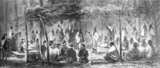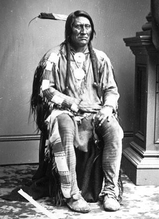
The Arapaho are a Native American people historically living on the plains of Colorado and Wyoming. They were close allies of the Cheyenne tribe and loosely aligned with the Lakota and Dakota.

The Cheyenne are an Indigenous people of the Great Plains. The Cheyenne comprise two Native American tribes, the Só'taeo'o or Só'taétaneo'o and the Tsétsêhéstâhese ; the tribes merged in the early 19th century. Today, the Cheyenne people are split into two federally recognized nations: the Southern Cheyenne, who are enrolled in the Cheyenne and Arapaho Tribes in Oklahoma, and the Northern Cheyenne, who are enrolled in the Northern Cheyenne Tribe of the Northern Cheyenne Indian Reservation in Montana. The Cheyenne language belongs to the Algonquian language family.

The Sand Creek massacre was a massacre of Cheyenne and Arapaho people by the U.S. Army in the American Indian Wars that occurred on November 29, 1864, when a 675-man force of the Third Colorado Cavalry under the command of U.S. Volunteers Colonel John Chivington attacked and destroyed a village of Cheyenne and Arapaho people in southeastern Colorado Territory, killing and mutilating an estimated 69 to over 600 Native American people. Chivington claimed 500 to 600 warriors were killed. However, most sources estimate around 150 people were killed, about two-thirds of whom were women and children. The location has been designated the Sand Creek Massacre National Historic Site and is administered by the National Park Service. The massacre is considered part of a series of events known as the Colorado Wars.

Black Kettle was a leader of the Southern Cheyenne during the American Indian Wars. Born to the Northern Só'taeo'o / Só'taétaneo'o band of the Northern Cheyenne in the Black Hills of present-day South Dakota, he later married into the Wotápio / Wutapai band of the Southern Cheyenne.

The Medicine Lodge Treaty is the overall name for three treaties signed near Medicine Lodge, Kansas, between the Federal government of the United States and southern Plains Indian tribes in October 1867, intended to bring peace to the area by relocating the Native Americans to reservations in Indian Territory and away from European-American settlement. The treaty was negotiated after investigation by the Indian Peace Commission, which in its final report in 1868 concluded that the wars had been preventable. They determined that the United States government and its representatives, including the United States Congress, had contributed to the warfare on the Great Plains by failing to fulfill their legal obligations and to treat the Native Americans with honesty.

The Territory of Colorado was an organized incorporated territory of the United States that existed from February 28, 1861, until August 1, 1876, when it was admitted to the Union as the State of Colorado.

The Dog Soldiers or Dog Men are historically one of six Cheyenne military societies. Beginning in the late 1830s, this society evolved into a separate, militaristic band that played a dominant role in Cheyenne resistance to the westward expansion of the United States in the area of present-day Kansas, Nebraska, Colorado, and Wyoming, where the Cheyenne had settled in the early nineteenth century.

The Battle of the Washita River occurred on November 27, 1868, when Lt. Col. George Armstrong Custer's 7th U.S. Cavalry attacked Black Kettle's Southern Cheyenne camp on the Washita River.

The Colorado War was an Indian War fought in 1864 and 1865 between the Southern Cheyenne, Arapaho, and allied Brulé and Oglala Sioux peoples versus the U.S. Army, Colorado militia, and white settlers in Colorado Territory and adjacent regions. The Kiowa and the Comanche played a minor role in actions that occurred in the southern part of the Territory along the Arkansas River. The Cheyenne, Arapaho, and Sioux played the major role in actions that occurred north of the Arkansas River and along the South Platte River, the Great Platte River Road, and the eastern portion of the Overland Trail. The United States government and Colorado Territory authorities participated through the 1st Colorado Cavalry Regiment, often called the Colorado volunteers. The war was centered on the Colorado Eastern Plains, extending eastward into Kansas and Nebraska.

The 3rd Colorado Cavalry Regiment was a Union Army unit formed in the mid-1860s when increased traffic on the United States emigrant trails and settler encroachment resulted in numerous attacks against them by the Cheyenne and Arapaho. The Hungate massacre and the display in Denver of mutilated victims raised political pressure for the government to protect its people. Governor John Evans sought and gained authorization from the War Department in Washington to found the Third. More a militia than a military unit, the "Bloodless Third" was composed of "100-daysers," that is, volunteers who signed on for 100 days to fight against the Indians. The unit's only commander was Col. George L. Shoup, a politician from Colorado. The regiment was assigned to the District of Colorado commanded by Col. John M. Chivington.

William Wells Bent was a frontier trader and rancher in the American West, with forts in Colorado. He also acted as a mediator among the Cheyenne Nation, other Native American tribes and the expanding United States. With his brothers, Bent established a trade business along the Santa Fe Trail. In the early 1830s Bent built an adobe fort, called Bent's Fort, along the Arkansas River in present-day Colorado. Furs, horses and other goods were traded for food and other household goods by travelers along the Santa Fe trail, fur-trappers, and local Mexican and Native American people. Bent negotiated a peace among the many Plains tribes north and south of the Arkansas River, as well as between the Native American and the United States government.

The Fort Laramie Treaty of 1851 was signed on September 17, 1851 between United States treaty commissioners and representatives of the Cheyenne, Sioux, Arapaho, Crow, Assiniboine, Mandan, Hidatsa, and Arikara Nations. Also known as Horse Creek Treaty, the treaty set forth traditional territorial claims of the tribes.

Lean Bear, alternatively translated as Starving Bear, was a Cheyenne peace chief. He was a member of the Council of Forty-four, a tribal governance devoted to maintaining peace with encroaching United States settlers. Lean Bear's most notable peace deals include the Treaty of Fort Wise and a meeting with US President Abraham Lincoln. His work towards peace between his people and the American settlers in the Southern Plains was cut short when he was killed by the 1st Colorado Cavalry Regiment and violent retaliations ensued.
The Council of Forty-four is one of the two central institutions of traditional Cheyenne Native American tribal governance, the other being the military societies such as the Dog Soldiers.

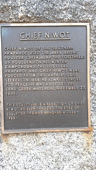
Chief Niwot or Left Hand(-ed) was a Southern Arapaho chief, diplomat, and interpreter who negotiated for peace between white settlers and the Cheyenne and Arapaho tribes during the Pike's Peak Gold Rush and Colorado War.

Friday (Arapaho: Teenokuhu or Warshinun, also known as Friday Fitzpatrick, was an Arapaho leader and interpreter in the mid to late 1800s. When he was around the age of eight, he was separated from his band and was taken in by a white trapper. During the next seven years, he was schooled in St. Louis, Missouri and went on trapping expeditions with his informally adopted father, Thomas Fitzpatrick. After he was recognized by his mother during an encounter with the Arapaho, he returned to the tribe.
Margaret Poisal was "the only woman who was an official witness, interpreter, and consultant at many meetings and treaty councils held along or in close proximity to the Santa Fe Trail." The daughter of French Canadian trapper John Poisal and Arapaho Snake Woman, Poisal was educated at a convent school. She married Thomas Fitzpatrick, an Indian agent, and they worked together negotiating peace between Native American tribes and the United States government. After Fitzpatrick died, Poisal continued to work as an interpreter and peacemaker.
Little Owl was a Northern Arapaho chief who signed the Treaty of Fort Laramie (1851). Disturbed by the ways in which the United States government neglected to honor their promises made in the treaty, Little Owl refused to participate in discussion and signing of the Fort Wise Treaty.

White Antelope was a chief of the Southern Cheyenne. He was known for his advocacy of peace between white Americans living in the Great Plains until his killing at the Sand Creek massacre. Accounts of the massacre conflict as to whether White Antelope led his people in resistance to the attack or continued to advocate for peace until his death. White Antelope's body was desecrated after the massacre, and the blanket he was wearing stolen.


