
Huerfano County is a county located in the U.S. state of Colorado. As of the 2020 census, the population was 6,820. The county seat is Walsenburg. The county, whose name comes from the Spanish huérfano meaning "orphan", was named for the Huerfano Butte, a local landmark. The area of Huerfano County boomed early in the 1900s with the discovery of large coal deposits. After large scale World War II coal demand ended in the 1940s Walsenburg and Huerfano saw a steady economic decline through 2015.

El Paso County is the most populous county located in the American state of Colorado. As of the 2020 Census, the population was 730,395, surpassing the City and County of Denver. The county seat is Colorado Springs, the second most populous city in Colorado. El Paso County is included in the Colorado Springs, Colorado, Metropolitan Statistical Area.

La Veta is a statutory town in Huerfano County, Colorado, United States. The town population was 862 as of the 2020 United States Census.

Walsenburg is the statutory city that is the county seat and the most populous municipality of Huerfano County, Colorado, United States. The city population was 3,049 at the 2020 census, down from 3,068 in 2010.

Dublin is a city and county seat of Laurens County, Georgia, United States. The population was 16,074 at the 2020 census.

Candler Park is a 55-acre city park located at 585 Candler Park Drive NE, in Atlanta, Georgia, United States. It is named after Coca-Cola magnate Asa Griggs Candler, who donated this land to the city in 1922. The park features a nine-hole golf course, a swimming pool, a football/soccer field, a basketball court, tennis courts, and a playground.
Cobbs Creek is a neighborhood located in the West Philadelphia section of Philadelphia, Pennsylvania, United States, named for the creek which forms part of Philadelphia's western border. Cobbs Creek is generally bounded by Market Street to the north, Baltimore Avenue to the south, 52nd Street to the east, and the border of Upper Darby along Cobbs Creek to the West.

The Spanish Peaks Wilderness is a 19,226 acres (77.80 km2) wilderness area in Huerfano County and Las Animas County, Colorado, United States, located 20 miles (32 km) southwest of Walsenburg. All of the wilderness area is located within San Isabel National Forest, which is managed by the U.S. Forest Service.

Badito is a ghost town along the Huerfano River in Huerfano County, Colorado, United States. It is located at the intersection of Colorado State Highway 69 and County Road 520. A post office named Little Orphan, Colorado opened on May 1, 1865, but the name was changed to Badito on September 12, 1865. Badito served as the Huerfano County seat from 1868 to 1874. The Badito post office closed on November 15, 1910.

This is an alphabetical list of articles related to the U.S. State of Colorado.

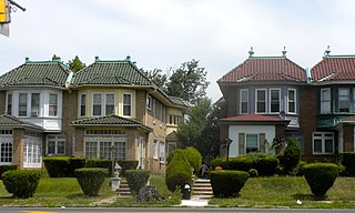
The Palmer Park Apartment Building Historic District is a neighborhood located in Detroit, Michigan, bounded by Pontchartrain Boulevard on the west, McNichols Road on the south, and Covington Drive on the northeast. A boundary increase pushed the eastern boundary to Woodward Avenue. The district showcases some of the most ornate and most varied examples of apartment building design in Michigan, and was listed on the National Register of Historic Places in 1983.

Cuchara is an unincorporated community in Huerfano County, Colorado, United States. It is located near a former ski resort in the mountains south of the town of La Veta. Its altitude is 8,468 feet (2,581 m). State Highway 12 travels through Cuchara as it approaches Trinidad to the southeast.

Lathrop State Park is a Colorado state park located 3 miles (4.8 km) west of Walsenburg. The state purchased the property in 1962 and opened Colorado's first state park here later that same year. It is named after Harold Lathrop, the first director of state parks. The park features two lakes, Martin Lake and Horseshoe Lake, that offer fishing for tiger muskie, rainbow trout, bass, catfish, northern pike, blue gill, saugeye, and wipers.

The Dennisville Historic District is a 60-acre (24 ha) national historic district in the Dennisville section of Dennis Township in Cape May County, New Jersey. The district is bounded by Petersburg Road, Main Street, Church Road, Hall Avenue, Fidler and Academy Roads, and Route 47. It was added to the National Register of Historic Places on November 24, 1987, for its significance in architecture, industry and maritime history. The district includes 58 contributing buildings. The district boundary was increased in 2016 and now includes the William S. Townsend House, which was previously listed individually.

Cucharas River is a 75-mile-long (121 km) tributary of the Huerfano River that flows from a source in Huerfano County, Colorado, southwest of the Spanish Peaks in San Isabel National Forest. The river passes through La Veta and Walsenburg before joining the Huerfano River in Pueblo County.
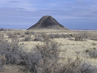
Huerfano Butte is a volcanic plug or hypabyssal plug located 8.8 miles (14.1 km) north of Walsenburg in Huerfano County, Colorado, United States. Named Huérfano by early Spanish explorers, it rises above the south side of the Huerfano River with its peak about 200 feet (61 m) above the floodplain.
The Huerfano County Courthouse and Old Walsenburg Jail now the Walsenburg Mining Museum, are historic buildings in Walsenburg, Colorado in Huerfano County. The courthouse was built in 1904. The jail was built in 1896. The buildings were added to the National Register of Historic Places on April 23, 1973. The courthouse is located at 400 Main Street. The jail is located at 112 West Fifth Street. The jail held Bob Ford, who killed Jesse James, and labor leader Mary "Mother" Jones.

William Thomas Sharp was a former Confederate soldier and later an explorer who operated a trading post on the Taos Trail and founded the now extinct town of Malachite, Colorado. It was located on the Huerfano River in Huerfano County, Colorado. He became a nationally known horse and cattle breeder.

Lola Spradley is an American politician from Colorado. She served as Speaker of the Colorado House of Representatives from 2003 to 2005, the first woman elected to the position.

The Huerfano Bridge, is a bridge in Pueblo County, Colorado near Boone, Colorado that brings U.S. Highway 50 over the Huerfano River. The bridge was completed in 1921 after construction began in 1920. It was listed on the National Register of Historic Places in 1985.


