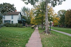
Auraria was a small mining settlement in the Kansas Territory in the United States. Today it survives in its original location as a neighborhood of Denver, Colorado, south of the confluence of Cherry Creek and the South Platte River.

Auraria Campus is an educational facility located near downtown Denver, Colorado in the United States. The campus houses facilities of three separate universities and colleges: the University of Colorado Denver, Community College of Denver (CCD), and Metropolitan State University of Denver. In 2017, there were approximately 54,812 students between the three schools, with rapid growth projected over the following few years. However, due to Covid and declining enrollment, the collective student population in 2022 was approximately 38,000, with an additional 5,000 faculty and staff.

There are more than 1,500 properties and historic districts in the U.S. State of Colorado listed on the National Register of Historic Places. They are distributed over 63 of Colorado's 64 counties; only the City and County of Broomfield currently has none.

The Colorado Convention Center (CCC) is a multi-purpose convention center located in Downtown Denver, Colorado. At 2,200,000 square feet it is currently the 12th largest convention center in the United States. It opened in June 1990; the first event being the NBA draft for the Denver Nuggets. The convention center was expanded in 2004 to include several meeting rooms, two ballrooms and an indoor amphitheater. Since opening, the center hosts an average of around 400 events per year. Centrally located in the city, it has become one of Denver's many landmarks due to its architecture and is adjacent to the Denver Performing Arts Complex and is just blocks away from the Colorado State Capitol, Auraria Campus and the 16th Street Mall. The CCC is directly served via light rail by RTD's Theatre District–Convention Center station.

The oldest part of Denver, Colorado, now the neighborhoods of Auraria Campus, LoDo, much of downtown, and Five Points, is laid out on a grid plan that is oriented diagonal to the four cardinal directions. The rest of the city, including the eastern part of downtown, is laid out primarily on a grid oriented to the cardinal directions. In this larger grid, from east to west, there are generally 16 city blocks per mile, except between Zuni Street and Lowell Boulevard in west Denver. From north to south, there are typically eight blocks per mile, although there are many areas with more blocks per mile. Addresses follow a decimal system, with addresses advancing by one hundred at each cross street.

St. Elmo is a ghost town in Chaffee County, Colorado, United States. Founded in 1880, St. Elmo lies in the heart of the Sawatch Range, 20 miles (32 km) southwest of Buena Vista and sits at an elevation of 9,961 feet (3,036 m). Nearly 2,000 people settled in this town when mining for gold and silver started. The mining industry started to decline in the early 1920s, and in 1922 the railroad discontinued service. The community is listed on the National Register of Historic Places as the St. Elmo Historic District. It is one of Colorado's best preserved ghost towns.

The Tivoli Brewery is a historic building originally home to the Tivoli Brewing Company. It was designed by prominent Denver architect Frederick C. Eberley. The building is located in the Auraria Neighborhood of Denver, Colorado. Today the building is home to the Tivoli Student Union of the Auraria Campus, serving as a student center for the Metropolitan State University of Denver, Community College of Denver, and the University of Colorado Denver. In August 2015 the revived Tivoli Brewing Company began brewing in a new facility inside the building, in the original brewing area.

The University of Colorado Denver is a public research university in Denver, Colorado. It is part of the University of Colorado system.

Metropolitan State University of Denver is a public university in Denver, Colorado. It is located on the Auraria Campus, along with the University of Colorado Denver and the Community College of Denver, in downtown Denver, adjacent to Speer Boulevard and Colfax Avenue. MSU Denver had an enrollment of 15,682 students in the Fall of 2022.
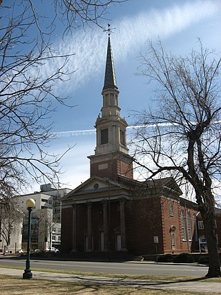
First Baptist Church of Denver is an historic church at 230 E. 14th Avenue-1373 Grant Street in Denver, Colorado. First Baptist Church of Denver ("FBCD") was formally organized in 1864, six years after the city's founding.
Frederick Albert Hale was an American architect who practiced in states including Colorado, Utah, and Wyoming. According to a 1977 NRHP nomination for the Keith-O'Brien Building in Salt Lake City, "Hale worked mostly in the classical styles and seemed equally adept at Beaux-Arts Classicism, Neo-Classical Revival or Georgian Revival." He also employed Shingle and Queen Anne styles for several residential structures. A number of his works are listed on the U.S. National Register of Historic Places.
Curtis–Champa Streets Historic District is located in Denver, Colorado. It was added to the National Register of Historic Places in 1975 and is bounded by Arapahoe, 30th, California, and 24th Sts. covering 870 acres and 356 buildings. In 1983 the boundaries were expanded to roughly 30th, Stout, Downing and Arapahoe Sts., covering 870 acres and 77 buildings.

The Emmanuel Gallery is an art gallery and historic building at 1205 10th Street in Denver, Colorado, United States, on the Auraria Campus.

James Murdoch (1844-1914) was "an important architect in Denver in the late 19th and early 20th centuries." Several of his works are listed on the National Register of Historic Places. At least two of his works have been designated Denver landmarks.

The Idaho Springs Downtown Commercial District includes Early Commercial architecture in Idaho Springs, Colorado. The historic district was listed on the National Register of Historic Places in 1984. The listing includes 46 contributing buildings on 9 acres (3.6 ha).

The G. W. & W. M. Clayton Building, also known as the Granite Hotel, Granite Building and the Clayton Building, is an 1882 commercial building in Denver, Colorado and is a Denver Landmark. It is a four-story building which was built in 1882 on the site of the first building in Denver, a log cabin. It was built to host the M.J. McNamara Dry Goods Company. G. W. & W. M. Clayton is inscribed near the top of the building for businessman George W. Clayton and his brother William M. Clayton, who served as mayor of Denver. The Denver Public Library has a photograph of the G. W. & W. M. Clayton Building.
Carolína Acuña Díaz González was a businesswoman and activist in the Denver Latinx community. In the 1950's, she opened "Casa Mayan," a prominent restaurant and community gathering space.