The Llano Uplift is a geologically ancient, low geologic dome that is about 90 miles (140 km) in diameter and located mostly in Llano, Mason, San Saba, Gillespie, and Blanco counties, Texas. It consists of an island-like exposure of Precambrian igneous and metamorphic rocks surrounded by outcrops of Paleozoic and Cretaceous sedimentary strata. At their widest, the exposed Precambrian rocks extend about 65 miles (105 km) westward from the valley of the Colorado River and beneath a broad, gentle topographic basin drained by the Llano River. The subdued topographic basin is underlain by Precambrian rocks and bordered by a discontinuous rim of flat-topped hills. These hills are the dissected edge of the Edwards Plateau, which consist of overlying Cretaceous sedimentary strata. Within this basin and along its margin are down-faulted blocks and erosional remnants of Paleozoic strata which form prominent hills.

The Front Range is a mountain range of the Southern Rocky Mountains of North America located in the central portion of the U.S. State of Colorado, and southeastern portion of the U.S. State of Wyoming. It is the first mountain range encountered as one goes westbound along the 40th parallel north across the Great Plains of North America.

The geology of the Grand Canyon area includes one of the most complete and studied sequences of rock on Earth. The nearly 40 major sedimentary rock layers exposed in the Grand Canyon and in the Grand Canyon National Park area range in age from about 200 million to nearly 2 billion years old. Most were deposited in warm, shallow seas and near ancient, long-gone sea shores in western North America. Both marine and terrestrial sediments are represented, including lithified sand dunes from an extinct desert. There are at least 14 known unconformities in the geologic record found in the Grand Canyon.

The geology of the Zion and Kolob canyons area includes nine known exposed formations, all visible in Zion National Park in the U.S. state of Utah. Together, these formations represent about 150 million years of mostly Mesozoic-aged sedimentation in that part of North America. Part of a super-sequence of rock units called the Grand Staircase, the formations exposed in the Zion and Kolob area were deposited in several different environments that range from the warm shallow seas of the Kaibab and Moenkopi formations, streams and lakes of the Chinle, Moenave, and Kayenta formations to the large deserts of the Navajo and Temple Cap formations and dry near shore environments of the Carmel Formation.
The exposed geology of the Bryce Canyon area in Utah shows a record of deposition that covers the last part of the Cretaceous Period and the first half of the Cenozoic era in that part of North America. The ancient depositional environment of the region around what is now Bryce Canyon National Park varied from the warm shallow sea in which the Dakota Sandstone and the Tropic Shale were deposited to the cool streams and lakes that contributed sediment to the colorful Claron Formation that dominates the park's amphitheaters.
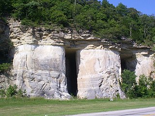
The St. Peter Sandstone is an Ordovician geological formation. It belongs to the Chazyan stage of the Champlainian series in North American regional stratigraphy, equivalent to the late Darriwilian global stage. This sandstone originated as a sheet of sand in clear, shallow water near the shore of a Paleozoic sea and consists of fine-to-medium-size, well-rounded quartz grains with frosted surfaces. The extent of the formation spans north-south from Minnesota to Arkansas and east-west from Illinois into Nebraska and South Dakota. The formation was named by Owen (1847) after the Minnesota River, then known as the St. Peter River. The type locality is at the confluence of the Mississippi and Minnesota Rivers near Fort Snelling, Minnesota. In eastern Missouri, the stone consists of quartz sand that is 99.44% silica.

The exposed geology of the Capitol Reef area presents a record of mostly Mesozoic-aged sedimentation in an area of North America in and around Capitol Reef National Park, on the Colorado Plateau in southeastern Utah.

The Denver Basin, variously referred to as the Julesburg Basin, Denver-Julesburg Basin, or the D-J Basin, is a geologic structural basin centered in eastern Colorado in the United States, but extending into southeast Wyoming, western Nebraska, and western Kansas. It underlies the Denver-Aurora Metropolitan Area on the eastern side of the Rocky Mountains.

The Dakota Hogback is a long hogback ridge at the eastern fringe of the Rocky Mountains that extends north-south from southern Wyoming through Colorado and into northern New Mexico in the United States. The ridge is prominently visible as the first line of foothills along the edge of the Great Plains. It is generally faulted along its western side, and varies in height, with gaps in numerous locations where rivers exit the mountains. The ridge takes its name from the Dakota Formation, a formation with resistant sandstone beds that cap the ridge. The hogback was formed during the Laramide orogeny, approximately 50 million years ago, when the modern Rockies were created. The general uplift to the west created long faulting in the North American Plate, resulting in the creation of the hogback.

The Dallas–Fort Worth Metroplex sits above Cretaceous-age strata ranging from ≈145-66 Ma. These Cretaceous-aged sediments lie above the eroded Ouachita Mountains and the Fort Worth Basin, which was formed by the Ouachita Orogeny. Going from west to east in the DFW Metroplex and down towards the Gulf of Mexico, the strata get progressively younger. The Cretaceous sediments dip very gently to the east.

The San Juan Basin is a geologic structural basin located near the Four Corners region of the Southwestern United States. The basin covers 7,500 square miles and resides in northwestern New Mexico, southwestern Colorado, and parts of Utah and Arizona. Specifically, the basin occupies space in the San Juan, Rio Arriba, Sandoval, and McKinley counties in New Mexico, and La Plata and Archuleta counties in Colorado. The basin extends roughly 100 miles (160 km) N-S and 90 miles (140 km) E-W.

The geology of England is mainly sedimentary. The youngest rocks are in the south east around London, progressing in age in a north westerly direction. The Tees–Exe line marks the division between younger, softer and low-lying rocks in the south east and the generally older and harder rocks of the north and west which give rise to higher relief in those regions. The geology of England is recognisable in the landscape of its counties, the building materials of its towns and its regional extractive industries.

The Fountain Formation is a Pennsylvanian bedrock unit consisting primarily of conglomerate, sandstone, or arkose, in the states of Colorado and Wyoming in the United States, along the east side of the Front Range of the Rocky Mountains, and along the west edge of the Denver Basin.

In geology and geomorphology, a hogback or hog's back is a long, narrow ridge or a series of hills with a narrow crest and steep slopes of nearly equal inclination on both flanks. Typically, the term is restricted to a ridge created by the differential erosion of outcropping, steeply dipping, homoclinal, and typically sedimentary strata. One side of a hogback consists of the surface of a steeply dipping rock stratum called a dip slope. The other side is an erosion face that cuts through the dipping strata that comprises the hogback. The name "hogback" comes from the Hog's Back of the North Downs in Surrey, England, which refers to the landform's resemblance in outline to the back of a hog. The term is also sometimes applied to drumlins and, in Maine, to both eskers and ridges known as "horsebacks".

The Dakota is a sedimentary geologic unit name of formation and group rank in Midwestern North America. The Dakota units are generally composed of sandstones, mudstones, clays, and shales deposited in the Mid-Cretaceous opening of the Western Interior Seaway. The usage of the name Dakota for this particular Albian-Cenomanian strata is exceptionally widespread; from British Columbia and Alberta to Montana and Wisconsin to Colorado and Kansas to Utah and Arizona. It is famous for producing massive colorful rock formations in the Rocky Mountains and the Great Plains of the United States, and for preserving both dinosaur footprints and early deciduous tree leaves.

The Pawnee Buttes are two prominent buttes in northeastern Colorado. The west butte is located within the Pawnee National Grassland, while the east butte is on private land in Weld County. Rising approximately 300 feet (91 m) above the surrounding plains, the buttes are erosional remnants left standing in isolation as the surrounding High Plains surface has gradually worn away. The lower portions of the buttes are composed of relatively soft, clay-rich sedimentary rock called the Brule formation. The Brule formation is protected by an overlying layer of sandstone and conglomerate sediments called the Arikaree formation, which are more resistant to weathering.
The Kiowa Formation or Kiowa Shale is a Cretaceous geologic formation in Kansas, diminishing to member status in Colorado and Oklahoma. In Colorado, the Kiowa Shale was classified as a member of the now abandoned Purgatoire Formation. In the vicinity of Longford, Kansas, the local Longford member comprises thinly bedded siltstone, clay, polished gravel, lignite, and sandstone suggests a river and estuary environment.

The bedrock under the U.S. State of Colorado was assembled from island arcs accreted onto the edge of the ancient Wyoming Craton. The Sonoma orogeny uplifted the ancestral Rocky Mountains in parallel with the diversification of multicellular life. Shallow seas covered the regions, followed by the uplift current Rocky Mountains and intense volcanic activity. Colorado has thick sedimentary sequences with oil, gas and coal deposits, as well as base metals and other minerals.

The geology of North Dakota includes thick sequences oil and coal bearing sedimentary rocks formed in shallow seas in the Paleozoic and Mesozoic, as well as terrestrial deposits from the Cenozoic on top of ancient Precambrian crystalline basement rocks. The state has extensive oil and gas, sand and gravel, coal, groundwater and other natural resources.

The Greater Green River Basin (GGRB) is a 21,000 square mile basin located in Southwestern Wyoming. The Basin was formed during the Cretaceous period sourced by underlying Permian and Cretaceous deposits. The GGRB is host to many anticlines created during the Laramide Orogeny trapping many of its hydrocarbon resources. It is bounded by the Rawlins Uplift, Uinta Mountains, Sevier overthrust belt, Sierra Madre Mountains, and the Wind River Mountain Range. The Greater Green River Basin is subdivided into four smaller basins, the Green River Basin, Great Divide Basin, Washakie Basin, and Sand Wash Basin. Each of these possesses hydrocarbons that have been economically exploited. There are 303 named fields throughout the basin, the majority of which produce natural gas; the largest of these gas fields is the Jonah Field.