
The South Platte River is one of the two principal tributaries of the Platte River. Flowing through the U.S. states of Colorado and Nebraska, it is itself a major river of the American Midwest and the American Southwest/Mountain West. Its drainage basin includes much of the eastern flank of the Rocky Mountains in Colorado, much of the populated region known as the Colorado Front Range and Eastern Plains, and a portion of southeastern Wyoming in the vicinity of the city of Cheyenne. It joins the North Platte River in western Nebraska to form the Platte, which then flows across Nebraska to the Missouri. The river serves as the principal source of water for eastern Colorado. In its valley along the foothills in Colorado, it has permitted agriculture in an area of the Colorado Piedmont and Great Plains that is otherwise arid.

The Platte River is a major American river, in the state of Nebraska. It is about 310 mi (500 km) long; measured to its farthest source via its tributary, the North Platte River, it flows for over 1,050 miles (1,690 km). The Platte River is a tributary of the Missouri River, which itself is a tributary of the Mississippi River which flows to the Gulf of Mexico. The Platte over most of its length is a broad, shallow, meandering stream with a sandy bottom and many islands—a braided stream.
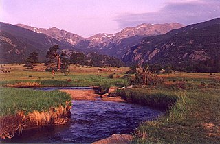
The Big Thompson River is a tributary of the South Platte River, approximately 78 miles (126 km) long, in the U.S. state of Colorado. Originating in Forest Canyon in Rocky Mountain National Park, the river flows into Lake Estes in the town of Estes Park and then through Big Thompson Canyon. It includes four crossings/bridges which are listed on the U.S. National Register of Historic Places.

LoDo is an unofficial neighborhood in Denver, Colorado, and is one of the oldest places of settlement in the city. It is a mixed-use historic district, known for its nightlife, and serves as an example of success in urban reinvestment and revitalization. The current population is approximately 21,145.

There are more than 1,500 properties and historic districts in the U.S. State of Colorado listed on the National Register of Historic Places. They are distributed over 63 of Colorado's 64 counties; only the City and County of Broomfield currently has none.
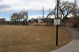
Lakewood Gulch drains a section of Lakewood and west Denver, Colorado into the South Platte River. It is the historic location of the old Interurban Shortline Railway and, in 2008, is a greenbelt that includes Rude Park, Sanchez Park and Lakewood Gulch Park. The gulch passes through Lakewood from west to east before entering the Denver neighborhoods of Sun Valley and Villa Park. It contains a part of the route of the (current) heritage streetcar Platte Valley Trolley and the Denver sections of the creek have an adjacent bike path. According to the Jefferson County Colorado Place Names Directory, "Lakewood Gulch originates on the north east foot of Green Mountain in Lakewood, flows east through Sixth Avenue West Park and Red Rocks Community College and continues east through Lakewood into Denver, where it joins the South Platte River southwest of the intersection of I-25 and Colfax Avenue."
The Nebraska Department of Transportation (NDOT) is the state government agency charged with building and maintaining the state highways in the U.S. state of Nebraska, as well as the state's airports. The main headquarters of the agency is located in Lincoln, the capital city. There are currently eight NDOT district offices located across the state.

Baker is a neighborhood in Denver, Colorado, United States.

There are more than 300 properties and districts listed on the National Register of Historic Places in the City and County of Denver, the capital of the U.S. State of Colorado.
This National Park Service list is complete through NPS recent listings posted November 15, 2024.
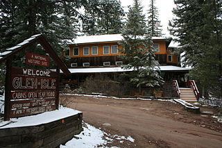
Glenisle, also known as Glen-Isle on the Platte and Glen Isle Resort, is a rustic-style resort hotel built at the turn of the 20th century. The hotel is located just off US Highway 285 in Bailey, Colorado, United States, and has been on the National Register of Historic Places since 1985.

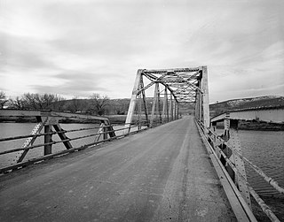
The Lisco State Aid Bridge is located on a county road over the North Platte River south of Lisco, Nebraska. Completed in 1928, the bridge today "is distinguished as an important crossing of the Platte River and one of the last two intact multiple-span state aid truss bridges" in Nebraska.

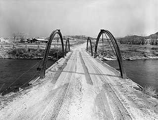
The 19th Street Bridge is a two-span through Pratt truss road bridge in Denver, Colorado, over the South Platte River, now used for pedestrians. It was built in 1888 to replace a wooden structure and carried automobile traffic until 1986. The bridge is listed on the National Register of Historic Places.

The Hayden Arch Bridge is a concrete arch bridge on old US 14/US 16 in Park County, Wyoming, United States, that is listed on the National Register of Historic Places {NRHP).

The DMJ Pick Bridge is a Parker through truss bridge located near Saratoga, Wyoming, which carries Carbon County Road CN6-508 across the North Platte River. The bridge was built from 1909 to 1910 by contractor Charles G. Sheely; it was originally located south of Fort Steele. In 1934, the bridge was moved up the river to its current location, as a new bridge had been built at its original site five years earlier. The bridge is the only Parker truss bridge remaining in Wyoming, after the Arvada Bridge was replaced in 1990.

The DML Butler Bridge is a historic bridge over the North Platte River in Carbon County, Wyoming, United States, that is listed on the National Register of Historic Places (NRHP).
The DUX Bessemer Bend Bridge was a Warren through truss bridge in Bessemer Bend, Wyoming, which carried Natrona County Road CN1-58 across the North Platte River. The bridge was built from 1921 to 1922. When nominated to the National Register of Historic Places in 1982, it was one of only three Warren through truss bridges remaining on Wyoming county highways. In addition, the bridge was located at the site of a historic river crossing on the Oregon Trail.
The ELS Bridge over Big Wind River is a pony truss bridge located near Dubois, Wyoming, which carries Fremont County Road CN10-21 across the Big Wind River. The bridge was built circa 1920. Its design is uncommon and merges a kingpost truss with an arched chord. The materials used to build the bridge are also unusual and were likely salvaged; for instance, the arches are made from tunnel sets.
The EWZ Bridge over East Channel of Laramie River is a Pratt pony truss bridge that was located near Wheatland, Wyoming, which carried Platte County Road CN8-204 over the East Channel of the Laramie River. The bridge was built from 1913 to 1914 by the Pueblo Bridge Company. The single-span bridge was 71 feet 2 inches (21.69 m) long. The bridge's five-panel Pratt pony truss design with steel pin connections was used fairly frequently in Wyoming highway bridges, and the bridge was one of the older examples of the style.
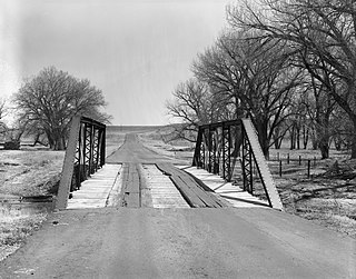
The South Platte River Bridge, in South Park near Lake George, Colorado, was built in 1920. It was listed on the National Register of Historic Places in 2018.
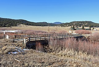
The Estabrook Historic District, southeast of Bailey, Colorado, is a 272-acre (110 ha) historic district which was listed on the National Register of Historic Places in 1980.


