The Samoan archipelago is a chain of 16 islands and numerous seamounts covering 3,123 km2 (1,206 sq mi) in the central South Pacific, south of the equator, about halfway between Hawaii and New Zealand, forming part of Polynesia and of the wider region of Oceania. The islands are Savaiʻi, Upolu, Tutuila, ’Uvea, Taʻū, Ofu, Olosega, Apolima, Manono, Nuʻutele, Niulakita, Nuʻulua, Namua, Fanuatapu, Rose Atoll, Nu'ulopa, as well as the submerged Vailuluʻu, Pasco banks, and Alexa Bank.
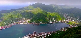
Pago Pago is the capital of American Samoa. It is in Maoputasi County on Tutuila, which is American Samoa's main island.

The Samoan Islands are an archipelago covering 3,030 km2 (1,170 sq mi) in the central South Pacific, forming part of Polynesia and of the wider region of Oceania. Administratively, the archipelago comprises all of the Independent State of Samoa and most of American Samoa. The land masses of the two Samoan jurisdictions are separated by 64 km (40 mi) of ocean at their closest points.
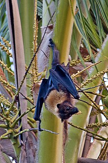
The National Park of American Samoa is a national park in the United States territory of American Samoa, distributed across four islands: Tutuila, Ofu, Olosega, and Ta‘ū. The park preserves and protects coral reefs, tropical rainforests, fruit bats, and the Samoan culture. Popular activities include hiking and snorkeling. Of the park's 8,257 acres (3,341 ha), 2,500 acres (1,000 ha) is coral reefs and ocean. The park is the only American National Park Service system unit south of the equator.

Taʻū is the largest inhabited island in the Manuʻa Islands and the easternmost volcanic island of the Samoan Islands. Taʻū is part of American Samoa. In the early 19th century, the island was sometimes called Opoun.
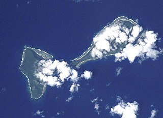
Ofu and Olosega are parts of a volcanic doublet in the Manuʻa Islands, which is a part of American Samoa in the Samoan Islands. These twin islands, formed from shield volcanoes, have a combined length of 6 km and a combined area of 12 square kilometers. Together, they have a population of about 500 people. Geographically, the islands are volcanic remnants separated by the narrow, 137-meter-wide (449-foot)) Āsaga Strait, composed of shallow-water coral reef. Before 1970, people crossed between the two islands by waiting until low tide and then wading across the shallow water of the strait. Since 1970, there has been a bridge over the strait, providing a single-lane road that connects the two islands.

Tutuila is the largest and most populous island of American Samoa and is part of the archipelago of the Samoan Islands. It is the third largest island in the Samoan Islands chain of the Central Pacific. It is located roughly 4,000 kilometers (2,500 mi) northeast of Brisbane, Australia and lies over 1,200 kilometers (750 mi) to the northeast of Fiji. It contains a large, natural harbor, Pago Pago Harbor, where Pago Pago, the capital of American Samoa, is situated. Pago Pago International Airport is also located on Tutuila. The island's land expanse is about 68% of the total land area of American Samoa. With 56,000 inhabitants, it is also home to 95% of the population of American Samoa. The island has six terrestrial and three marine ecosystems.

The Manuʻa Islands, or the Manuʻa tele, in the Samoan Islands, consists of three main islands: Taʻū, Ofu and Olosega. The latter two are separated only by the shallow, 137-meter-wide Āsaga Strait, and are now connected by a bridge over the strait. The islands are located some 110 kilometers east of Tutuila and are a part of American Samoa, an unincorporated territory of the United States. Their combined area is 56 square kilometers, and they have a total population of 1,400. Taʻu is the largest of these islands, with an area of 44 km2 (17 sq mi), and it has the highest point of the Manuʻa, at 931 meters. Politically, the islands form the Manuʻa District, one of the three administrative divisions of American Samoa.
Utulei or ʻUtulei is a village in Maoputasi County, in the Eastern District of Tutuila, the main island of American Samoa. Utulei is traditionally considered to be a section of Fagatogo village, the legislative capital of American Samoa, and is located on the southwest edge of Pago Pago Harbor. Utulei is the site of many local landmarks: The A. P. Lutali Executive Office Building, which is next to the Feleti Barstow Library; paved roads that wind up to a former cablecar terminal on Solo Hill; the governor's mansion, which sits on Mauga o Alii, overlooking the entrance to Goat's Island, and the lieutenant governor's residence directly downhill from it; the Lee Auditorium, built in 1962; American Samoa's television studios, known as the Michael J. Kirwan Educational Television Center; and the Rainmaker Hotel. Utulei Terminal offers views of Rainmaker Mountain.

Aunuʻu is a small volcanic island off the southeastern shore of Tutuila in Saʻole County, American Samoa. It has a land area of 374.83 acres, and a 2010 census population of 436 persons. Politically, it is a part of the Eastern District, one of the two primary political divisions of American Samoa.

Tafuna is a village in Tualauta County, Western District, American Samoa. It is the most populous village in American Samoa, with a population of 7,988 according to the 2020 U.S. Census, and is the center of nightlife on island.

The following outline is provided as an overview of and topical guide to American Samoa:
American Samoa is an unincorporated territory of the United States located in the South Pacific Ocean, southeast of the island country of Samoa. Centered on 14.3°S 170.7°W, it is east of the International Date Line and the Wallis and Futuna Islands, west of the Cook Islands, north of Tonga, and some 500 kilometers (310 mi) south of Tokelau. American Samoa is the southernmost territory of the United States and one of two U.S. territories south of the Equator, along with the uninhabited Jarvis Island.

Āfono is a village on the northeast coast of Tutuila Island, American Samoa. One of the island's more populous villages, it is located on the edge of Afono Bay, at the eastern edge of the National Park of American Samoa. It is connected by Highway 6 to Vatia, which lies along the coast to the northwest, and to Aua, on the edge of Pago Pago Harbor to the south via a winding stretch of highway which crosses the spine of the island.

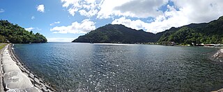
Vatia is a village on Tutuila Island in American Samoa. It is a north shore village located on Vatia Bay. The road to Vatia, American Samoa Highway 006, is the only road going through National Park of American Samoa. Vatia is a scenic community at the foot of Pola Ridge and surrounded by the national park. It is only reached by Route 6 which traverses the national park before reaching Vatia. There was once a hiking trail over Maugaloa Ridge from Leloaloa, but since the completion of Route 6, this trail is now overgrown. It is home to a beach, and panoramic views of jungle-covered peaks surround the village on all sides. Vatia is the center of the Tutuila-section of National Park of American Samoa. It is located in Vaifanua County.
Fagasā is a village in the Eastern District of Tutuila Island in American Samoa. The village lies by Fagasa Bay, on the north shore of the island. Its name is Samoan and translates to “Forbidden Bay.” The village borders the Tutuila-section of National Park of American Samoa. The trailhead to Mount ‘Alava is located near the village by Fagasa Pass.
Lumā is a village on the northwest coast of Taʻū Island in American Samoa, south of the village of Taʻū and north of Siʻufaga. The last Tui Manuʻa is buried in Lumā. It is also where anthropologist Margaret Mead researched and authored her classic Coming of Age in Samoa in 1925. Lumā and neighboring Siʻufaga are subvillages of the Village of Taʻū.

Vailuluʻu is a volcanic seamount discovered in 1975. It rises from the sea floor to a depth of 593 m (1,946 ft) and is located between Taʻu and Rose islands at the eastern end of the Samoa hotspot chain. The basaltic seamount is considered to mark the current location of the Samoa hotspot. The summit of Vailuluʻu contains a 2 km wide, 400 m deep oval-shaped caldera. Two principal rift zones extend east and west from the summit, parallel to the trend of the Samoan hotspot. A third less prominent rift extends southeast of the summit.
Ottoville is a subdivision or district within the village of Tafuna, American Samoa.
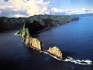
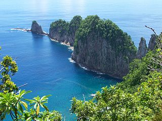
Pola Island is an island just offshore from the village of Vatia on Tutuila Island in American Samoa. It is also known as Cockscomb. Pola Island is designated as part of the National Park American Samoa, and is a popular tourist attraction. It is located on the west side of Vatia Bay, and serves as both a landmark and an icon for Vatia. Pola Island has been named one of American Samoa's Seven National Wonders by the Pago Pages. It has been named "the most beautiful natural feature of Tutuila Island” by travel guide publisher Lonely Planet. Pola Island is known for its high cliffs, populated by seabirds, and is one of American Samoa's primary seabird nesting sites.