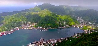
Pago Pago is the capital of American Samoa. It is in Maoputasi County on Tutuila, which is American Samoa's main island.
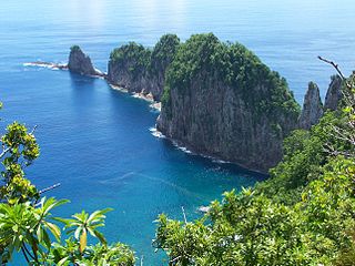
The National Park of American Samoa is a national park in the United States territory of American Samoa, distributed across four islands: Tutuila, Ofu, Olosega, and Ta‘ū. The park preserves and protects coral reefs, tropical rainforests, fruit bats, and the Samoan culture. Popular activities include hiking and snorkeling. Of the park's 8,257 acres (3,341 ha), 2,500 acres (1,000 ha) is coral reefs and ocean. The park is the only American National Park Service system unit south of the equator.

Fagatogo is the downtown area of Pago Pago. Located in the low grounds at the foot of Matafao Peak, it was the location of the first American settlement on Tutuila Island. It includes the sub-village of Malaloa. Today, Fagatogo is the government, commercial, financial, and shipping center of Tutuila. It is also the administrative capital of American Samoa. It is the location of the American Samoa Fono (legislature), and is listed in the Constitution of American Samoa as the territory's official seat of government. Its population is 1,737.
Poloa is a village in American Samoa. It is located at the west side of Tutuila in the Alataua District. The village has 193 residents in 2010. The main denominations in the area are Methodist and Christian. Poloa has one elementary school. It is located in Lealataua County.

Leone is the second-largest city on Tutuila Island's west coast. The village is on the south-west coast of Tutuila Island, American Samoa. Leone was the ancient capital of Tutuila Island. Leone was also where the Samoan Islands’ first missionary, John Williams, visited on October 18, 1832. A monument in honor of Williams has been erected in front of Zion Church. Its large church was the first to be built in American Samoa. It has three towers, a carved ceiling and stained glass. Until steamships were invented, Leone was the preferred anchorage of sailing ships which did not risk entering Pago Pago Harbor. Much early contact between Samoans and Europeans took place in Leone.

Tafuna is a village in Tualauta County, Western District, American Samoa. It is the most populous village in American Samoa, with a population of 7,988 according to the 2020 U.S. Census, and is the center of nightlife on island.

The Blunts Point Battery, also known as Blunts Point Naval Gun or Matautu Ridge Gun Site, is a gun battery on Matautu Ridge near Pago Pago, American Samoa. It was part of the fortification of the Samoan Islands which took place after the attack on Pearl Harbor, and is a rare example of a World War II Pacific coastal gun which remains in relatively pristine condition. It was declared a National Historic Landmark in 1987.
ʻAmanave is a village on the coast of Tutuila Island, American Samoa. It is located close to the island's western tip, Cape Taputapu, and to the south of the village of Poloa. It is located in Lealataua County.
Amaluia is a village on the southwest coast of Tutuila Island, American Samoa. It is located between Leone and 'Amanave. It is located in Lealataua County.
Āmouli is a village on the southeast coast of Tutuila Island, American Samoa at the narrowest point of the island. It is located to the west of 'Au'asi, immediately to the south of 'Aoa on the north coast. It was home to 920 residents at the 2010 U.S. Census, all of which were Pacific Islanders by race. It is located in Sa'Ole County.
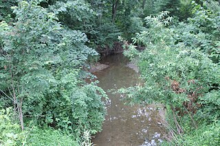
Fagaʻalu is a village in central Tutuila Island, American Samoa. It is also known as Fagaʻalo. It is located on the eastern shore of Pago Pago Harbor, to the south of Pago Pago. American Samoa's lone hospital, Lyndon B. Johnson Tropical Medical Center, is located in Fagaʻalu. The village is centered around Fagaalu Stream.
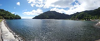
A'asu or Āsu is a village on the north coast of Tutuila Island, American Samoa. It is located to the west of Fagasa and northwest of Pago Pago. It is one of multiple villages involved in an archaeological survey of the island. A'asu lies on Massacre Bay and can be reached from a hiking trail in A'asufou. Massacre Bay can be visited by car, aiga buses, or through excursions offered by North Shore Tours.
McKee Run is a tributary of County Line Branch in Montour County, Pennsylvania, in the United States. It is approximately 4.1 miles (6.6 km) long and flows through Anthony Township. The watershed of the stream has an area of 2.68 square miles (6.9 km2). The stream is designated as impaired by siltation and removal of vegetation due to agriculture. Land uses in the watershed include forested land, croplands, and pastures. A number of bridges cross the stream.
Sauquoit Creek is a 17.0-mile-long (27.4 km) river in New York, United States. It lies within the southern part of Oneida County. The creek flows eastward, then turns sharply and flows generally northward through the Sauquoit Valley to the Mohawk River, entering the river on the east side of Whitesboro. It is therefore part of the Hudson River watershed.

Rolling Green Run is a tributary of the Susquehanna River in Snyder County, Pennsylvania, in the United States. It is approximately 3.3 miles (5.3 km) long and flows through Monroe Township. The watershed of the stream has an area of 2.04 square miles (5.3 km2). The stream is designated as an impaired waterbody due to habitat alteration from golf courses. Its drainage basin is designated as a Warmwater Fishery and a Migratory Fishery.
Otsquago Creek is a river that enters the Mohawk River in Fort Plain, New York. Otsquago is a Mohawk Indian word meaning 'under the bridge,' probably referring to an early bridge of felled trees along the creek, a way of making small bridges. It is also referred to as Otsquage on old maps, which is an Indian word for 'healing waters'.

The Canajoharie Creek is a river that flows into the Mohawk River in the Village of Canajoharie in the U.S. State of New York. The name "Canajoharie" is a Mohawk language term meaning "the pot that washes itself", referring to the "Canajoharie Boiling Pot", a 20-foot (6.1 m) wide and 10-foot (3.0 m) deep pothole in the Canajoharie Creek, just south of the village of Canajoharie. Bowmans Creek is one main tributary that enters the creek east of the Hamlet of Sprout Brook. The other main tributary is Brimstone Creek which enters the creek north-northwest of the Village of Ames.
Fagasā is a village in the Eastern District of Tutuila Island in American Samoa. The village lies by Fagasa Bay, on the north shore of the island. Its name is Samoan and translates to “Forbidden Bay.” The village borders the Tutuila-section of National Park of American Samoa. The trailhead to Mount ‘Alava is located near the village by Fagasa Pass.
Pava'ia'i is a village in the Western District of Tutuila Island in American Samoa. It borders Mapasagafou and Faleniu to the north, 'Ili'ili to the east, Futiga to the south, and Malaeloa to the west. It is located in Tuālāuta County.
Pala Lagoon is an indentation in the south coast of Tutuila Island in American Samoa. The villages of Nu'uuli and Tafuna are located on its shore. Pala Lagoon is approximately one mile across and has a surface area of around 75 square miles (190 km2) The lagoon's depth varies from 1 foot (0.30 m)-5 feet (1.5 m) depending on the tide. The deepest areas of the lagoon were dredged when the Tafuna Airport runway was built in the 1960s. The entrance to the lagoon is about 1,200 feet (370 m) wide with a shallow reef top 1 foot (0.30 m)-3 feet (0.91 m) in depth. Along the northern and eastern shores, a 90-acre (36 ha) forest is located with red and oriental mangroves. The lagoon's northern shore has various streams which discharge into Pala Lagoon. The largest streams are Papa and Vaitele. There is a public recreation area known as Lions Park on the western edge of the lagoon, in the village of Tafuna. Pala Lagoon is also utilized for fishing and crabbing on a daily basis. It is a very important nursery and spawning ground for many fish and invertebrates found on the reef.
