Vaitogi

Last updated
Vaitogi
Village
Etymology: Samoan: "water thrown"
American Samoa location map.svg
Red pog.svg
Vaitogi
Coordinates: 14°21′S170°44′W / 14.350°S 170.733°W / -14.350; -170.733
CountryFlag of the United States.svg  United States
TerritoryFlag of American Samoa.svg  American Samoa
County Tuālāuta
Area
  Total1.25 sq mi (03.25 km2)
Population
 (2010)
  Total1,959
  Density1,600/sq mi (600/km2)
Demonym(s) Vaitogian
Time zone Samoa Time Zone
ZIP code
96799
Area code(s) +1 684

Vaitogi is a village in American Samoa. It has many missionaries and tourists who are attracted by shopping for local products. Vaitogi might be most famous of its legends about the Turtle and Shark (Laumei ma Malie). It is said that once, at a time when food was scarce, an old woman took her granddaughter to the bluff at Vaitogi, and holding hands, they leaped into the sea down below. While the young girl was transformed into a shark, the blind grandmother became a turtle. [1] It gives its name to a local U-shaped cove in town, which was listed on the U.S. National Register of Historic Places in 2014.

Contents

Fogāma'a Crater Trail is a 3-mile roundtrip hiking trail in Vaitogi. The trail goes by two scenic beaches before ending at the junction with the Fagatele Bay National Marine Sanctuary Trail. [2] Fogāma'a Crater is a National Natural Landmark.

It is home to Tessarea Vaitogi Inn, which is a hotel in town. [3] [4]

Etymology

Although there is no specific account of the name’s origin, the name may be related to the lack of water in the area, according to oral tradition. The name Vaitogi translates to “water thrown”. [5]

History

Fogama'a Crater National Natural Landmark Fogama'a Crater.jpg
Fogama'a Crater National Natural Landmark

Vaitogi was first located in the Fogāma'a Crater, located on the southwestern coast of the present-day village. It had rich soil for farming and plenty of game for hunting nearby, however, families began moving away from Fogāma'a before the end of the 19th century to the present-day location due to convenience and ease in connecting with other villages. The present location is much closer if traveled by foot. Evidence of early village settlement can still be found in Fogāma'a and Vaitogians often visit Fogāma'a to enjoy the bay and beach. [6]

Vaitogi was visited by Robert J. Maxwell in 1965-1966, who sampled 52 participants in a 22-month research project inspired by the theories of Hans Eysenck concerning Extraversion and introversion behavior. [7]

Vaitogi villagers gather once every year to commemorate an incident that happened over a century ago. At one point, a fire raged through the village for days and could not be extinguished, threatening lives and destroying scores of acres of vegetation and crops. After the village chiefs gathered to pray for the fires to end, heavy rain supposedly fell extinguishing the flames. The village observes a 24-hour curfew once per year to mark the event. [8]

Toeupu of Vaitogi became the first person to be convicted and hanged for murder in American Samoa. Toeupu was assassinated on July 1, 1921, for killing Sake of Leone over a gambling debt. [9] Toeupu armed himself with a shotgun and sought out Sake of Leone, whom he fired upon and killed. He was arrested and brought to trial eleven days later. He confessed his guilt and was sentenced to be hanged. California lawyer C.S. Hannum found the execution of a self-confessed killer, only 26 days after the commission of the crime, to be intolerable. He complained to President Calvin Coolidge about the “illegal hanging of a Samoan.” [10]

Margaret Mead

Historical population [11]
2010 1,959
2000 1,347
1990 1,302
1980 664
1970 473
1960 409
1950 421
1940 235
1930 217

Archaeologist Margaret Mead stayed in Pago Pago for six weeks when she studied the Samoan language. She later spent ten days in Vaitogi as the guest of the local chief in town. The chief and villagers treated her like royalty, and provided her with a bed made of twenty woven mats topped with a blanket and sheets. The villagers also gave her information and access to elders in distant villages. [12] She was on the island of Tutuila for a total of two months. Vaitogi was Mead's favorite Samoan village, and she wrote to a friend: “Here they love me and I love them”. [13]

She also described her stay: “It was there [in Vaitogi] I had all my essential training in how to manage Samoan etiquette… I learned to eat and enjoy Samoan food and to feel unabashed when, as a guest, I was served first and the whole family sat about sedately waiting for me to finish so that they, in turn, could eat… Day by day I grew easier in the language, sat more correctly… I learned how to relate to other people in terms of their rank and how to reply in terms of the rank they accorded me." [14]

Geography

Vaitogi is located on the southern tip of Tutuila Island. On clear days, the island of Aunu'u in the east can be seen from the shores in town. It is twelve miles southwest of Pago Pago. Vaitogi’s coastline is made up of rugged cliffs and molten lava rocks, with a few patches of sand. There is no reef except at the secluded Fogāma'a Beach situated at Fogāma'a Crater, which is listed as a National Marine Sanctuary. [15]

Economy

Vaitogians have been traditionally known to be skilled farmers, and the large flatlands toward inland Vaitogi were a great advantage for the farmers. Vaitogi is also notable for its past sugar cane fields. The sugar cane leaves were woven into thatches for the roofs of fales (houses). The Vaitogi farmers also planted palm trees to cater to the demands of roof thatching. The products were often sold at the Fagatogo Market. Agriculture was a vital source of income particularly after families began settling further inland. Crops such as cucumber, head cabbage, pineapple, and lime are still brought from Vaitogi to be sold at the Fagatogo Market. [16]

Demographics

Vaitogi was home to 1,347 residents at the 2000 U.S. Census, where 35.1% of residents were foreign-born. [17] 53 percent were male and 47 percent female. The majority were under the age of fifty. According to the 2010 U.S. Census, the village was home to 1,959, a large increase since the year 2000. The village is also home people from Western Samoa, Fiji, Tonga, Korea, China, and Tokelau. [18]

Religion

Vaitogians worshipped in private homes and guest houses of the village chiefs until the church was built in the 1850s. The first Christian denomination to be established in the village was the Congregational Christian Church in American Samoa. Other denominations in Vaitogi are the Seventh-day Adventists, Tongan Methodists, Baháʼí, and the Assembly of God. [19]

Sports

The village’s traditional symbol and icon is Pisisami (sea breeze). The icon is often used in athletic activities and private business. In professional sports, the men’s cricket team has won the islandwide championship title several years, and the women’s cricket team has won the championship in the women’s division. [20]

Landmarks

Notable people

Related Research Articles

Amerika Samoa is the regional anthem of American Samoa. Composed by Napoleon Andrew Tuiteleleapaga and written by Mariota Tiumalu Tuiasosopo, it was officially adopted in 1950.

Fagatogo Village in American Samoa, United States

Fagatogo is the downtown area of Pago Pago. Located in the low grounds at the foot of Matafao Peak, it was the location of the first American settlement on Tutuila Island. It includes the sub-village of Malaloa. Today, Fagatogo is the government, commercial, financial, and shipping center of Tutuila. It is also the administrative capital of American Samoa. It is the location of the American Samoa Fono (legislature), and is listed in the Constitution of American Samoa as the territory's official seat of government. Its population is 1,737.

Poloa, American Samoa Village in American Samoa, United States

Poloa is a village in American Samoa. It is located at the west side of Tutuila in the Alataua District. The village has 193 residents in 2010. The main denominations in the area are Methodist and Christian. Poloa has one elementary school. It is located in Lealataua County.

Vaiʻava Strait

Vaiʻava Strait is the name of a narrow strait located in Vatia, American Samoa. It is a 250 acres (100 ha) National Natural Landmark. The strait is a great example of cliffs formed by waves on volcanic rock. The strait consists of communal lands. It was designated as a U.S. National Natural Landmark in 1972. Vai'ava Strait separates the 420 feet (130 m) high Pola Tai Island from Polauta Ridge. Pola-Uta is connected to the village of Vatia on Tutuila Island. Pola Tai is a 400 feet (120 m) cliff that is an important nesting area for the fua'ō and tava'e. Hunting of brown boobies, known as the A'ega o le Pola, was a tradition carried out by Vatians in the past. Pola Tai includes Matalia Point, Cockscomb Point and Polauta Ridge.

Leone, American Samoa Village in American Samoa, United States

Leone is the second-largest city on Tutuila Island's west coast. The village is on the south-west coast of Tutuila Island, American Samoa. Leone was the ancient capital of Tutuila Island. Leone was also where the Samoan Islands’ first missionary, John Williams, visited on October 18, 1832. A monument in honor of Williams has been erected in front of Zion Church. Its large church was the first to be built in American Samoa. It has three towers, a carved ceiling and stained glass. Until steamships were invented, Leone was the preferred anchorage of sailing ships which did not risk entering Pago Pago Harbor. Much early contact between Samoans and Europeans took place in Leone.

Outline of American Samoa Overview of and topical guide to American Samoa

The following outline is provided as an overview of and topical guide to American Samoa:

Aoloau Village in American Samoa, United States

A'oloau is a village in the west of Tutuila Island, American Samoa. It is located inland, 5 miles (8 km) southwest of Pago Pago. It is also known as A’oloaufou, which means "new A’olou". An abandoned area in town by A'oloau Bay is known as A'oloautuai, which means Old A’oloau’. A'oloau's nickname is Nuu Puaolele which means the Fog Village.

Pago Pago Harbor Bay in American Samoa

Pago Pago Harbor on Tutuila Island in American Samoa is one of the world's largest natural harbors. The capital, Pago Pago is located on the inner reaches of the harbor, close to its northwesternmost point. It has the highest annual rainfall of any harbor in the world. It is also considered one of the best and deepest deepwater harbors in the South Pacific Ocean or in Oceania as a whole. Pago Pago Bay is over 400 feet (120 m) deep and two miles (3.2 km) long. As part of the Pago Volcano caldera, the harbor is 50% landlocked,

The Samoa News is a newspaper published in Pago Pago, American Samoa. In 1981, Samoa News was the major newspaper distributed in both of the Samoas. In January 1985, Lewis Wolman became editor of Samoa News. The Samoa News Ltd. was established in 1986, with Fuga Teleso as the majority shareholder. Wolman purchased Teleso's shares on November 18, 1986, and became the publisher-editor for Samoa News. It began printing on a web press in December 1989, allowing for an increase in paper size. In January 1990, it became the first daily newspaper in America Samoa, printed at its new facilities in the downtown Pago Pago location in Fagatogo. Fuga Tolani Teleso was Chairman of the board.

Jean P. Haydon Museum United States historic place

The Jean P. Haydon Museum is a museum in Pago Pago dedicated to the culture and history of the United States territory of American Samoa. It contains a collection of canoes, coconut-shell combs, pigs’ tusk armlets and native pharmacopoeia. It also houses exhibits on natural history, tapa making, traditional tattooing, as well as a collection of war clubs, kava bowls, and historic photographs. Constructed in 1913 as U.S. Naval Station Tutuila Commissary, the building was home to Tutuila Island's Post Office from 1950 to 1971. The museum has displays of various aspects of the Samoan Islands’ culture and history. It is the official repository for collections of artifacts for American Samoa. Funded by the American Samoa Council on Arts, Culture and the Humanities, it is the venue used for numerous of the cultural resource activities in American Samoa.

Vailoatai, American Samoa Village in American Samoa, United States

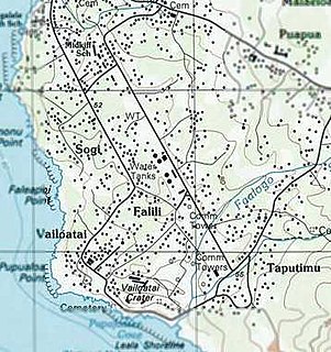
Vailoatai is a village in southwestern Tutuila, the main island of American Samoa. It is located on the eastern end of Leone Bay. The village is known for its beautiful malae located along the island's rugged southern coast, lined by the fale tali mālō of its village chiefs.

Vatia, American Samoa Village in American Samoa, United States

Vatia is a village on Tutuila Island in American Samoa. It is a north shore village located on Vatia Bay. The road to Vatia, American Samoa Highway 006, is the only road going through National Park of American Samoa. Vatia is a scenic community at the foot of Pola Ridge and surrounded by the national park. It is only reached by Route 6 which traverses the national park before reaching Vatia. There was once a hiking trail over Maugaloa Ridge from Leloaloa, but since the completion of Route 6, this trail is now overgrown. It is home to a beach, and panoramic views of jungle-covered peaks surround the village on all sides. Vatia is the center of the Tutuila-section of National Park of American Samoa. It is located in Vaifanua County.

Maʻopūtasi County County in American Samoa ----, United States

Maʻopūtasi County is located in the Eastern District of Tutuila Island in American Samoa. Maʻopūtasi County comprises the capital of Pago Pago and its harbor, as well as surrounding villages. It was home to 11,695 residents as of 2000. Maʻopūtasi County is 6.69 square miles (17.3 km2) The county has a 7.42-mile (11.94 km) shoreline which includes Pago Pago Bay.

Fagasā, American Samoa Village in American Samoa, United States

Fagasā is a village in the Eastern District of Tutuila Island in American Samoa. The village lies by Fagasa Bay, on the north shore of the island. Its name is Samoan and translates to “Forbidden Bay.” The village borders the Tutuila-section of National Park of American Samoa. The trailhead to Mount ‘Alava is located near the village by Fagasa Pass.

Sailele, American Samoa Village in American Samoa, United States

Sa'ilele is a village on the north shore in the Eastern District of Tutuila Island in American Samoa. It is reached from a cross-island road which leads north from the village of Faga'itua. By turning off at the pass, the turn-off takes you down a narrow road through dense forest to Sa'ilele. The village is known for having some of Tutuila's best swimming beaches. The sandy area below the rock outcrops at the western end of the beach is also a popular site for picnics. On a track east of the village is a burial ground where some ali'i were buried.

Tualatai County

Tuālā-tai County is one of the five counties that make up the Western District of American Samoa.

Tuālāuta County

Tuālāuta County is a county in the Western District in American Samoa. It is the largest and also the most populated county in American Samoa. The county is represented by two seats in the Senate and two seats in House of Representatives in the American Samoa Legislature. 'Ili'ili is the principal place in Tualauta County, a county which consists of 'Ili'ili, Vaitogi, Saleauau, Tafuna, Pavaia'i, and Faleniu.

Malaloa is a sub-village of Fagatogo and is located at the end of Pago Pago Harbor in American Samoa. It is located in-between Fagatogo proper and the village of Pago Pago. Cruising boats entering and leaving Pago Pago should clear at Malaloa Marina. The Malaloa Marina was opened for cruisers’ use and has added a customs wharf to handle inbound and outbound clearances.

Pola Island Island in American Samoa

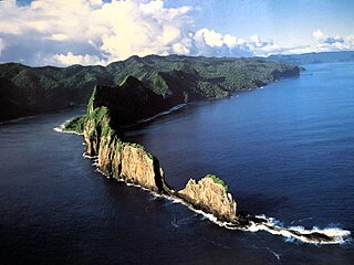
Pola Island is an island just offshore from the village of Vatia on Tutuila Island in American Samoa. It is also known as Cockscomb. Pola Island is designated as part of the National Park American Samoa, and is a popular tourist attraction. It is located on the west side of Vatia Bay, and serves as both a landmark and an icon for Vatia. Pola Island has been named one of American Samoa's Seven National Wonders by the Pago Pages. It has been named "the most beautiful natural feature of Tutuila Island” by travel guide publisher Lonely Planet. Pola Island is known for its high cliffs, populated by seabirds, and is one of American Samoa's primary seabird nesting sites.

Fogamaa Crater

Fogama'a Crater is a valley basin on Tutuila Island, American Samoa, immediately north of Larsen Bay. It is within the village of Futiga, just below Logotala Hill. It is also known as Hidden Beach or Larsen’s Cove.

References

  1. Stanley, David (2004). Moon Handbooks South Pacific. Moon Handbooks. Page 480. ISBN   9781566914116.
  2. "Day Hikes" (PDF). National Park Service. Retrieved 30 November 2021.
  3. National Geographic Society (2001). National Geographic Guide to the National Parks of the United States. Page 215. ISBN   9780792270287.
  4. Oswald, Michael Joseph (2017). Your Guide to the National Parks: The Complete Guide to All 59 National Parks. Stone Road Press. Page 714. ISBN   9781621280682.
  5. Fai’ivae, Alex Godinet (2018). Ole Manuō o Tala Tu’u Ma Fisaga o Tala Ave. Amerika Samoa Humanities Council. Page 115. ISBN   9781546229070.
  6. Fai’ivae, Alex Godinet (2018). Ole Manuō o Tala Tu’u Ma Fisaga o Tala Ave. Amerika Samoa Humanities Council. Page 117. ISBN   9781546229070.
  7. Holmes, Lowell D. (1988). Quest for the Real Samoa: The Mead-Freeman Controversy and Beyond. Greenwood Publishing Group. Page 134. ISBN   9780897891622.
  8. "American Samoa village observes annual 24 hour closure". RNZ. 17 September 2008. Retrieved 30 November 2021.
  9. Sunia, Fofo I.F. (2009). A History of American Samoa. Amerika Samoa Humanities Council. Page 220. ISBN   9781573062992.
  10. Gray, John Alexander Clinton (1980). Amerika Samoa. Arno Press. Page 206. ISBN   9780405130380.
  11. "American Samoa Statistical Yearbook 2016" (PDF). American Samoa Department of Commerce.
  12. Mark, Joan (1999). Margaret Mead: Coming of Age in America. Oxford University Press. Pages 10, 30 and 35. ISBN   9780190283490.
  13. Shankman, Paul (2009). The Trashing of Margaret Mead: Anatomy of an Anthropological Controversy. University of Wisconsin Press. Page 99. ISBN   9780299234539.
  14. Shankman, Paul (2009). The Trashing of Margaret Mead: Anatomy of an Anthropological Controversy. University of Wisconsin Press. Pages 91-92. ISBN   9780299234539.
  15. Fai’ivae, Alex Godinet (2018). Ole Manuō o Tala Tu’u Ma Fisaga o Tala Ave. Amerika Samoa Humanities Council. Pages 114 and 129. ISBN   9781546229070.
  16. Fai’ivae, Alex Godinet (2018). Ole Manuō o Tala Tu’u Ma Fisaga o Tala Ave. Amerika Samoa Humanities Council. Pages 126-127. ISBN   9781546229070.
  17. Census of population and housing (2000): American Samoa Summary Social, Economic, and Housing Characteristics (2000). DIANE Publishing. Page 53. ISBN   9781428985490.
  18. Fai’ivae, Alex Godinet (2018). Ole Manuō o Tala Tu’u Ma Fisaga o Tala Ave. Amerika Samoa Humanities Council. Page 114. ISBN   9781546229070.
  19. Fai’ivae, Alex Godinet (2018). Ole Manuō o Tala Tu’u Ma Fisaga o Tala Ave. Amerika Samoa Humanities Council. Pages 127-128. ISBN   9781546229070.
  20. Fai’ivae, Alex Godinet (2018). Ole Manuō o Tala Tu’u Ma Fisaga o Tala Ave. Amerika Samoa Humanities Council. Page 125. ISBN   9781546229070.
  21. Craig, Robert D. (2002). Historical Dictionary of Polynesia. Scarecrow Press. Pages 14-15. ISBN   9780810842373.
  22. Lal, Brij V. and Kate Fortune (2000). The Pacific Islands: An Encyclopedia, Volume 1. University of Hawaii Press. Page 288. ISBN   9780824822651.
  23. Sutter, Frederic Koehler (1989). The Samoans: A Global Family. University of Hawaii Press. Page 210. ISBN   9780824812386.