
Tutuila is the largest and most populous island of American Samoa and is part of the archipelago of the Samoan Islands. It is the third largest island in the Samoan Islands chain of the Central Pacific. It is located roughly 4,000 kilometers (2,500 mi) northeast of Brisbane, Australia and lies over 1,200 kilometers (750 mi) to the northeast of Fiji. It contains a large, natural harbor, Pago Pago Harbor, where Pago Pago, the capital of American Samoa, is situated. Pago Pago International Airport is also located on Tutuila. The island's land expanse is about 68% of the total land area of American Samoa. With 56,000 inhabitants, it is also home to 95% of the population of American Samoa. The island has six terrestrial and three marine ecosystems.

Aunuʻu is a small volcanic island off the southeastern shore of Tutuila in Saʻole County, American Samoa. It has a land area of 374.83 acres, and a 2010 census population of 436 persons. Politically, it is a part of the Eastern District, one of the two primary political divisions of American Samoa.

Āfono is a village on the northeast coast of Tutuila Island, American Samoa. One of the island's more populous villages, it is located on the edge of Afono Bay, at the eastern edge of the National Park of American Samoa. It is connected by Highway 6 to Vatia, which lies along the coast to the northwest, and to Aua, on the edge of Pago Pago Harbor to the south via a winding stretch of highway which crosses the spine of the island.
ʻAmanave is a village on the coast of Tutuila Island, American Samoa. It is located close to the island's western tip, Cape Taputapu, and to the south of the village of Poloa. It is located in Lealataua County.

Alega is a village on the southeast coast of Tutuila Island, American Samoa. One of the island's least populous villages, it is located to the east of Pago Pago Harbor and to the west of Faga'itua Bay.
Alofau is a village on the southeast coast of Tutuila Island, American Samoa. It is located at the eastern end of Faga'itua Bay, six miles east of Pago Pago, between Pagai and Amouli. It is home to Alofau Village Marine Protected Area. It is an agrarian and traditional village. It is also a poor village with residents with low literacy and high unemployment rates. As of the U.S. Census 2000, the per capita income was $4,357 and 67 percent of children were below the poverty line. 15.6 percent of residents were receiving public assistance. It is lauded as a kava place in the Manu'a Songs. Alofau is located in Sa'Ole County.
Āmouli is a village on the southeast coast of Tutuila Island, American Samoa at the narrowest point of the island. It is located to the west of 'Au'asi, immediately to the south of ʻAoa on the north coast. It was home to 920 residents at the 2010 U.S. Census, all of which were Pacific Islanders by race. It is located in Sa'Ole County.
ʻAoa is a village on the north-east coast of Tutuila Island, American Samoa. It is located on the north coast, close to the island's eastern tip, at a narrowing of the island and is connected by road with Amouli on the south coast. ʻAoa is the oldest site on Tutuila to yield ceramics. Located in a large U-shaped valley on the northeast coast of the island, ʻAoa sits on a wide, sandy beach fronted by a large, deep bay. Fresh water is supplied by a steady river which runs through the village. It is located in Vaifanua County.

Pago Pago Harbor on Tutuila Island in American Samoa is one of the world's largest natural harbors. The capital, Pago Pago is located on the inner reaches of the harbor, close to its northwesternmost point. It has the highest annual rainfall of any harbor in the world. It is also considered one of the best and deepest deepwater harbors in the South Pacific Ocean or in Oceania as a whole. Pago Pago Bay is over 400 feet (120 m) deep and two miles (3.2 km) long. As part of the Pago Volcano caldera, the harbor is 50% landlocked.
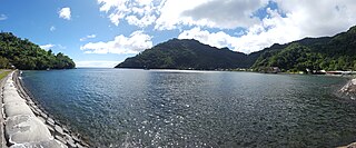
Fagaʻitua is a village in the east of Tutuila Island, American Samoa. It is located on the central coast of Fagaʻitua Bay. It is in Sua County, a county also known as ʻo le falelima i sasaʻe. Fagaitua is located at a shallow bay on the south coast of the island, in-between Lauli'i and Alofau. It is home to Luafagā, Le'iato's house of chiefs, and the big malae Malotumau.
Fagaʻalu is a village in central Tutuila Island, American Samoa. It is also known as Fagaʻalo. It is located on the eastern shore of Pago Pago Harbor, to the south of Pago Pago. American Samoa's lone hospital, Lyndon B. Johnson Tropical Medical Center, is located in Fagaʻalu. The village is centered around Fagaalu Stream.
Aʻasu or Āsu is a village on the north coast of Tutuila Island, American Samoa. It is located to the west of Fagasa and northwest of Pago Pago. It is one of multiple villages involved in an archaeological survey of the island. Aʻasu lies on Massacre Bay and can be reached from a hiking trail in Aʻasufou. Massacre Bay can be visited by car, aiga buses, or through excursions offered by North Shore Tours.

Matafao Peak is a mountain in American Samoa, on the island of Tutuila. With an elevation of 653 metres (2,142 ft), it is the highest peak on Tutuila Island. The mountain, like Rainmaker Mountain across Pago Pago Harbor, is a remnant of a volcanic plug and is part of the volcanic origins of the island. The mountain can be hiked from the high point of the Pago Pago-to-Fagasa Road. It is designated a National Natural Landmark above the 492-foot (150 m) level, an area known as Matafao Peak National Natural Landmark.

Vatia is a village on Tutuila Island in American Samoa. It is a north shore village located on Vatia Bay. The road to Vatia, American Samoa Highway 006, is the only road going through National Park of American Samoa. Vatia is a scenic community at the foot of Pola Ridge and surrounded by the national park. It is only reached by Route 6 which traverses the national park before reaching Vatia. There was once a hiking trail over Maugaloa Ridge from Leloaloa, but since the completion of Route 6, this trail is now overgrown. It is home to a beach, and panoramic views of jungle-covered peaks surround the village on all sides. Vatia is the center of the Tutuila-section of National Park of American Samoa. It is located in Vaifanua County.
Tula is a village in the Eastern District of Tutuila Island in American Samoa. Tula is located in Vaifanua County and had a population of 405 as of the 2010 U.S. Census.
Fagasā is a village in the Eastern District of Tutuila Island in American Samoa. The village lies by Fagasa Bay, on the north shore of the island. Its name is Samoan and translates to "Forbidden Bay." The village borders the Tutuila-section of National Park of American Samoa. The trailhead to Mount 'Alava is located near the village by Fagasa Pass.
Pavaʻiaʻi is a village in the Western District of Tutuila Island in American Samoa. It borders Mapasagafou and Faleniu to the north, ʻIliʻili to the east, Futiga to the south, and Malaeloa to the west. It is located in Tuālāuta County.

Itūʻau County is a county in the Eastern District in American Samoa. The official name is Itūʻau ma Nofo, however, it is commonly known as just Itūʻau. It is divided into northern and southern parts by the highest part of the Tutuila's central mountain range. It is peculiar in that it had no county chief. In Nuʻuuli in the south, power was divided between village high chief Savusa and the Four Chiefly Houses of the Soliai, Tago, Levu, and Alega. In Fagasā in the north, leadership was shared by the Tupuola and the Alo. The physical division of the county by mountains combined with the lack of a high chief made the county a battleground (itu'au) in ancient times.
Saʻole County is a county in the Eastern District in American Samoa. The county consists of Aunu'u Island together with its foothold upon Tutuila Island, Ālōfau and Āmouli.
Lauliʻi is a village on the eastern side of Tutuila Island in American Samoa. It is located in Sua County. Entering the village of Lauliʻi, one has to climb a small hill where a lighthouse is located. The village's rugby club is named after the lighthouse — Moli ole Ava. It is one of the most successful and oldest clubs in the territory. Many well-known players have emerged from Lauliʻi, such as Vui Eli Tagaloa, the current coach, Ropeti Taula, and others. The village is divided into two sections: Lauliʻituai and Lauliʻifou .As of Late 2020 there are 6 Christian Worship Churches in Lauliʻi. The Methodist, The Catholic, The London Missionary Society, Church, Assembly of God, Church of Christ Latter Day Saints Lauliʻi Ward, Saint John's Episcopal Church. Breakers Point Naval Guns, which is listed on the U.S. National Register of Historic Places is located at Tafananai near Lauliʻifou.
