Pago Pago is the territorial capital of American Samoa. It is in Maoputasi County on the main island of American Samoa, Tutuila. It is home to one of the deepest natural deepwater harbors in the South Pacific Ocean, sheltered from wind and rough seas, and strategically located. The harbor is also one of the best protected in the South Pacific, which gives American Samoa a natural advantage with respect to landing fish for processing. Tourism, entertainment, food, and tuna canning are its main industries. Pago Pago was the world's fourth largest tuna processor as of 1993. It was home to two of the largest tuna companies in the world: Chicken of the Sea and StarKist, which exported an estimated $445 million in canned tuna to the U.S. mainland. It is the number one port in the U.S. in terms of value of fish landed - about $200,000,000 annually.

Poloa is a village in American Samoa. It is located at the west side of Tutuila in the Alataua District. The village has 193 residents in 2010. The main denominations in the area are Methodist and Christian. Poloa has one elementary school. It is located in Lealataua County.

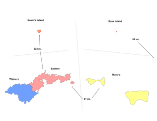
The Eastern District is one of the primary districts of American Samoa. It consists of the eastern portion of Tutuila, American Samoa's largest island, plus the island of Aunu'u. The district has a land area of 67.027 km2 and a 2010 census population of 23,030. It contains 34 villages plus a portion of Nu'uuli village. Among these are Pago Pago, Fagatogo, and Utulei.

Nu'uuli is a village on the central east coast of Tutuila Island, American Samoa. It is located on a peninsula several miles up from Pago Pago International Airport. Nu’uui is located between Pago Pago International Airport and Coconut Point. It is a shopping district which is home to stores such as South Pacific Traders, Nu’uuli Shopping Center, Aiga Supermarket and many more shops.

Tafuna is a village on the east coast of Tutuila Island, American Samoa. It is located on a mile north of Pago Pago International Airport and one mile south of Nu'uuli, American Samoa. The Ottoville district is a part of Tafuna. Near the Catholic church at Ottoville is an archeological park containing a well-preserved ancient Polynesian mound as well as a rainforest reserve. Tafuna is located on the Tafuna Plain, which is the largest flatland on the island of Tutuila.

Pagai is a village on the southeast coast of Tutuila Island, American Samoa. It is located on the edge of Faga'itua Bay, and in between the villages of Faga'itua and Alofau. Pagai is six miles east of Pago Pago.

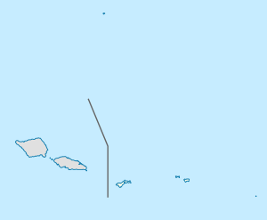
American Samoa is an unincorporated territory of the United States located in the South Pacific Ocean, southeast of Samoa. Its location is centered on 14.2710° S, 170.1322° W. It is east of the International Date Line, while Samoa is west of the Line.

Afao is a village in southwest Tutuila Island, American Samoa. It is located on the island's short southwestern coast, between 'Amanave and Leone, to the southwest of Pago Pago. It includes the settlement of Atauloma. Afao is home to two places listed on the U.S. National Register of Historic Places: Afao Beach Site and Atauloma Girls School.

Āfono is a village on the northeast coast of Tutuila Island, American Samoa. One of the island's more populous villages, it is located on the edge of Afono Bay, at the eastern edge of the National Park of American Samoa. It is connected by Highway 6 to Vatia, which lies along the coast to the northwest, and to Aua, on the edge of Pago Pago Harbor to the south via a winding stretch of highway which crosses the spine of the island.

Alega is a village on the southeast coast of Tutuila Island, American Samoa. One of the island's least populous villages, it is located to the east of Pago Pago Harbor and to the west of Faga'itua Bay.

Alofau is a village on the southeast coast of Tutuila Island, American Samoa. It is located at the eastern end of Faga'itua Bay, six miles east of Pago Pago, between Pagai and Amouli. It is home to Alofau Village Marine Protected Area. It is an agrarian and traditional village. It is also a poor village with residents with low literacy and high unemployment rates. As of the U.S. Census 2000, the per capita income was $4,357 and 67 percent of children were below the poverty line. 15.6 percent of residents were receiving public assistance. It is lauded as a kava place in the Manu'a Songs. Alofau is located in Sa'Ole County.

A'oloau is a village in the west of Tutuila Island, American Samoa. It is located inland, 5 miles (8 km) southwest of Pago Pago. It is also known as A’oloaufou, which means "new A’olou". An abandoned area in town by A'oloau Bay is known as A'oloautuai, which means Old A’oloau’. A'oloau's nickname is Nuu Puaolele which means the Fog Village.

Atu'u is a village on Tutuila Island, American Samoa. It is located on the coast of Pago Pago Harbor, close to the capital, Pago Pago.

A'umi is a village on the central south coast of Tutuila Island, American Samoa.

Pago Pago Harbor on Tutuila Island in American Samoa is one of the world's largest natural harbors. The capital, Pago Pago is located on the inner reaches of the harbor, close to its northwesternmost point. It has the highest annual rainfall of any harbor in the world. It is also considered one of the best and deepest deepwater harbors in the South Pacific Ocean or in Oceania as a whole. Pago Pago Bay is over 400 feet (120 m) deep and two miles (3.2 km) long. As part of the Pago Volcano caldera, the harbor is 50% landlocked,

Faga'alu is a village in central Tutuila Island, American Samoa. It is also known as Faga‘alo. It is located on the eastern shore of Pago Pago Harbor, to the south of Pago Pago. American Samoa's lone hospital, Lyndon B. Johnson Tropical Medical Center, is located in Faga'alu. The village is centered around Fagaalu Stream.

Maʻopūtasi County is located in the Eastern District of Tutuila Island in American Samoa. Maoputasi County comprises the capital of Pago Pago and its harbor, as well as surrounding villages. It was home to 11,695 residents as of 2000. Maoputasi County is 6.69 sq. mi. The county has a 7.42-mile shoreline which includes Pago Pago Bay.
Lumā is a village on the northwest coast of Ta'ū Island in American Samoa, south of the village of Ta'u and north of Si'ufaga. The last Tu'i Manu'a is buried in Luma. It is also where anthropologist Margaret Mead researched and authored her classic Coming of Age in Samoa in 1925. Luma and neighboring Si'ufaga are subvillages of the Village of Ta'u.
Malaloa is a sub-village of Fagatogo and is located at the end of Pago Pago Harbor in American Samoa. It is located in-between Fagatogo proper and the village of Pago Pago. Cruising boats entering and leaving Pago Pago should clear at Malaloa Marina. The Malaloa Marina was opened for cruisers’ use and has added a customs wharf to handle inbound and outbound clearances.
Satala is one of Pago Pago’s constituent villages and is located in Pago Pago Bay on Tutuila Island. Satala is in Maoputasi County in the Eastern District of the island. It is home to the historic Satala Cemetery, which is listed on the U.S. National Register of Historic Places, and the government-owned Ronald Reagan Marina Railway Shipyard.


