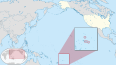
Rose Atoll, sometimes called Rose Island or Motu O Manu by people of the Manu'a Islands, is an oceanic atoll within the U.S. territory of American Samoa. An uninhabited wildlife refuge, it is the southernmost point belonging to the United States, about 170 miles to the east of Tutuila, the principal island of American Samoa. The land area is just 0.05 km2 at high tide. The total area of the atoll, including lagoon and reef flat amounts to 6.33 km2. Just west of the northernmost point is a channel into the lagoon, about 80 metres (260 ft) wide. There are two islets on the northeastern rim of the reef, larger Rose Island, 3.5 metres (11 ft) high, in the east and the non-vegetated Sand Island, 1.5 metres (5 ft) high, in the north.
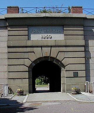
Fort Warren is a historic fort on the 28-acre (110,000 m2) Georges Island at the entrance to Boston Harbor. The fort is named for Revolutionary War hero Dr. Joseph Warren, who sent Paul Revere on his famous ride, and was later killed at the Battle of Bunker Hill. The name was transferred in 1833 from the first Fort Warren – built in 1808 – which was renamed Fort Winthrop.

This is a list of the buildings, sites, districts, and objects listed on the National Register of Historic Places in American Samoa. There are currently 31 listed sites spread across the three districts of American Samoa. There are no sites listed on the unorganized atoll of Swains Island.

Buildings, sites, districts, and objects in Virginia listed on the National Register of Historic Places:
Utulei or ʻUtulei is a village in Maoputasi County, in the Eastern District of Tutuila, the main island of American Samoa. Utulei is traditionally considered to be a section of Fagatogo village, the legislative capital of American Samoa, and is located on the southwest edge of Pago Pago Harbor. Utulei is the site of many local landmarks: The A. P. Lutali Executive Office Building, which is next to the Feleti Barstow Library; paved roads that wind up to a former cablecar terminal on Solo Hill; the governor's mansion, which sits on Mauga o Alii, overlooking the entrance to Goat's Island, and the lieutenant governor's residence directly downhill from it; the Lee Auditorium, built in 1962; American Samoa's television studios, known as the Michael J. Kirwan Educational Television Center; and the Rainmaker Hotel. Utulei Terminal offers views of Rainmaker Mountain.

American Samoa is administratively divided into three districts and two unorganized atolls. The districts are subdivided into 15 counties, which are composed of 76 villages.
Nuʻuuli is a village on the central east coast of Tutuila Island, American Samoa. It is located on a peninsula several miles up from Pago Pago International Airport. Nuʻuuli is located between Pago Pago International Airport and Coconut Point. It is a shopping district which is home to stores, groceries and many more shops. In the early 20th century, Nuʻuuli was the headquarters for the Mau movement in American Sāmoa.

The following is an alphabetical list of articles related to the United States Territory of American Samoa.

Government House, also known as Building No.1, Naval Station, Tutuila or Government House, U.S. Naval Station Tutuila, is a historic government building on the grounds of the former United States Naval Station Tutuila in Pago Pago, American Samoa. Built in 1903, it has served as a center of government on the island for much of the time since then. Government House was listed on the United States National Register of Historic Places in 1972, and was declared a National Historic Landmark in 1990.

American Samoa is an unincorporated territory of the United States located in the Polynesia region of the South Pacific Ocean. Centered on 14.3°S 170.7°W, it is 40 miles (64 km) southeast of the island country of Samoa, east of the International Date Line and the Wallis and Futuna Islands, west of the Cook Islands, north of Tonga, and some 310 miles (500 km) south of Tokelau. American Samoa is the southernmost territory of the United States, situated 2,200 miles (3,500 km) southwest of the U.S. state of Hawaii, and one of two U.S. territories south of the Equator, along with the uninhabited Jarvis Island.
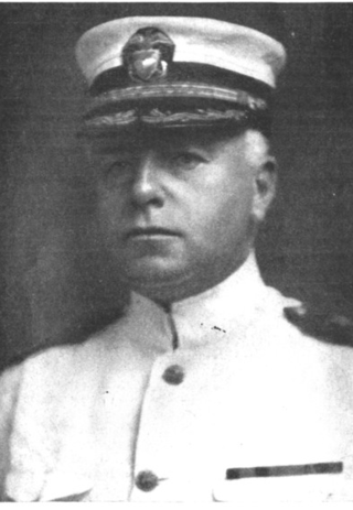
Warren Jay Terhune was a United States Navy Commander, and the governor of American Samoa. Terhune was born in Midland Park, New Jersey, and lived in New Jersey most of his life when not posted elsewhere. He was appointed to the United States Naval Academy in 1889 and graduated as a lieutenant in 1899. He was stationed on numerous ships and held command of various ships and stations throughout his career. His most notable command posts include the Seventh Naval District of South Florida and the Naval Air Station Key West within his jurisdiction. His largest engagement came when President William Howard Taft ordered the United States Marine Corps to Nicaragua in an attempt to put down a rebellion there, primarily out of the city of Managua. Terhune commanded USS Annapolis, which landed hundreds of troops to quell the violence and protect American civilians and property.

The Courthouse of American Samoa, formerly Administration Building, Navy No. 21, is a historic building near Pago Pago Harbor in Fagatogo, American Samoa. It is a two-story wood-frame building mounted on concrete piers, with a two-story veranda on three sides. A concrete vault is located at the back of the building. The court house was reported by the local commander to have been completed about 1904. It housed the offices and other facilities from which the United States Navy administered the island from its construction until 1952, and was where advisory councils of the island's indigenous leaders were held. The building is one of the oldest standing in American Samoa, having survived typhoons and other perils.
The Japanese Lighthouse, or Poluwat Lighthouse, is an abandoned lighthouse situated on Alet Island in Poluwat, Chuuk in the Federated States of Micronesia. It was completed in 1940 by the Japanese and was in use until being attacked by U.S. forces in World War II. It was listed on the National Register of Historic Places in 1983. The lighthouse is a good example of pre-World War II "marine architecture" built by the Japanese.
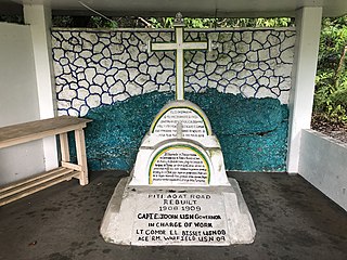
The Atantano Shrine is a historic commemorative marker near Piti, Guam. It is a pyramidal structure of coral limestone and concrete, about 2.5 metres (8.2 ft) in height, with base dimensions of 1.6 metres (5.2 ft). It is topped by a wooden cross and protected by an open concrete shelter. The monument was built in at least three stages, the early stages acting as bases for the mounting of the later ones. Panels on three sides carry inscriptions. The oldest inscription marks the initial construction of the road between Piti and Agat under the governorship of Don Felipe Cerain in 1784–85. The second inscription commemorates the creation of rice fields in the area under by Governor Don Francisco Villabos in 1832–34, and the third marks the reconstruction of the coast road during the governorship of Edward John Dorn in 1908–09. Commemorative markers of this type were a fixture of Spanish colonial administration that were adopted by Guamanians. The shrine has been the site of annual festivities since before World War II.
The Nan'yō Kōhatsu Kabushiki Kaisha complex was the main support base of the Nan'yō Kōhatsu Kabushiki Kaisha (NKKK) on the island Tinian in the Northern Mariana Islands. The NKKK was an economic development company established by the Empire of Japan to develop the territories of the South Seas Mandate, which it oversaw between the First and Second World Wars. In the Northern Marianas, the company aggressively developed arable areas for sugar cane farming, importing workers from Japan, Okinawa, and Korea. Each of the three major islands had major support facility. On Tinian, this area, now roughly where the island's largest community, San Jose is located on the south coast, consisted of an extensive development, most of which was destroyed during the Battle of Tinian in the Second World War. Of this large complex, only four buildings or structures remain, all of which have been listed on the United States National Register of Historic Places, as rare surviving examples of pre-war Japanese architecture on the islands.
Site As-31-72 is a prehistoric archaeological site on the island of Tutuila in the United States territory of American Samoa. Located on the Tafuna Plain, an inland area on the western half of the island, its principal feature is a long stone wall, 300 metres (980 ft) long with a maximum height of 5.4 metres (18 ft). Set on sloping ground, the top of the wall is roughly level, and is only 2.8 metres (9.2 ft) high at the upper end of the slope. Platforms and other features have been identified during archaeological examination of the structure and its surroundings in the 1990s. Its purpose is unknown; the researchers conjecture it was built because of warfare.
The Tui Manu'a Graves Monument is a funerary marker and grave site on the island Ta'u, the largest island of the Manu'a group in American Samoa. It is located northwest of the junction of Ta'u Village and Ta'u Island Roads on the west side of the island. It consists of a stone platform, about 3 feet (0.91 m) in height, that is roughly rectangular in shape with a projection at one end. Three graves are marked by square sections of smoothed stones, while a fourth is marked by a marble column. A possible fifth grave, unmarked, is in the projection. It is the burial site of several tu'i, or kings, of Manu'a, including Tui Manu'a Matelita and Tui Manu'a Elisala, the Samoan leader whose signature granted the United States hegemony over the islands.

Vatia is a village on Tutuila Island in American Samoa. It is a north shore village located on Vatia Bay. The road to Vatia, American Samoa Highway 006, is the only road going through National Park of American Samoa. Vatia is a scenic community at the foot of Pola Ridge and surrounded by the national park. It is only reached by Route 6 which traverses the national park before reaching Vatia. There was once a hiking trail over Maugaloa Ridge from Leloaloa, but since the completion of Route 6, this trail is now overgrown. It is home to a beach, and panoramic views of jungle-covered peaks surround the village on all sides. Vatia is the center of the Tutuila-section of National Park of American Samoa. It is located in Vaifanua County.

The Morgan Morgan Monument, also known as Morgan Park, is a 1.05-acre (0.4 ha) roadside park in the unincorporated town of Bunker Hill in Berkeley County, West Virginia. It is located along Winchester Avenue and Mill Creek. The park features a granite monument that was erected in 1924 to memorialize Morgan Morgan (1688–1766), an American pioneer of Welsh descent, who was among the earliest European persons to settle permanently within the present-day boundaries of West Virginia.

International Boundary Marker No. 1, U.S. and Mexico is a monument on the Mexico–U.S. border, on the west bank of the Rio Grande River near El Paso, Texas. It was listed on the National Register of Historic Places in 1974 and designated as a National Historic Civil Engineering Landmark by the American Society of Civil Engineers in 1976.