Colonial Peak is a mountain in the North Cascades of Washington, United States. It rises steeply from the southwest bank of Thunder Arm of Diablo Lake, one of the artificial reservoirs on the Skagit River. It is part of a group of peaks that form the northern end of a chain running south through prized climbing destinations such as Eldorado Peak, Forbidden Peak, and Goode Mountain. Colonial Peak takes its name from the Colonial mining claim on its slopes.

Desolation Peak is in the North Cascade Mountains of Washington state, about 6.2 miles (10.0 km) south of the Canada–United States border and in the Ross Lake National Recreation Area. It was first climbed in 1926 by Lage Wernstedt, who named it for the destruction caused by a forest fire that swept the slopes bare that same year. At the summit stands a small wooden one-room fire lookout belonging to the National Park Service. The lookout is 15 miles (24 km) from the nearest road and overlooks miles of forest and numerous other peaks.

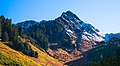
Mount Larrabee is a 7,865-foot (2,397-metre) Skagit Range mountain summit situated 1.4 mile south of the Canada–United States border, in the North Cascades of Washington state. It is located immediately southeast of American Border Peak within the Mount Baker Wilderness, which is part of the Mount Baker-Snoqualmie National Forest, and near North Cascades National Park. It is notable for its reddish coloring caused by oxidation of Iron in the rock. The rock consists of reddish interbedded and interfolded phyllites and greenstone. Originally known as Red Mountain, the name was changed in 1951 to honor Charles F. Larrabee (1895–1950), of the prominent Larrabee family of Bellingham, Washington. The toponym was officially adopted in 1951 by the U.S. Board on Geographic Names.

Helen Buttes are two prominent summits near the western edge of the North Cascades, in Skagit County of Washington state. The buttes are located four miles northwest of Marblemount, Washington, in the Noisy-Diobsud Wilderness, on land administered by the Mount Baker-Snoqualmie National Forest. The nearest higher neighbor is Diobsud Buttes, 3.11 miles (5.01 km) to the north. Precipitation runoff from Helen Buttes drains into tributaries of the Skagit River.

Crooked Bum is a 6,937-foot-elevation mountain summit on the crest of the North Cascades in the U.S. state of Washington. It is located in the Okanogan–Wenatchee National Forest on the shared border of Skagit County and Chelan County. It is situated immediately west of Rainy Pass and two miles east of Corteo Peak. The scenic and popular Maple Pass Trail traverses the south slope of the peak while staying above Lake Ann. Precipitation runoff from the north slope of Crooked Bum drains into Granite Creek which is a tributary of the Skagit River, whereas the south side drains into Bridge Creek which is a tributary of the Chelan River.

Mount Misch is a remote 7,435 ft mountain summit in the North Cascades, in Skagit County of Washington state. It is the highest point of the Buckindy Range, or Buckindy Ridge. It is located 19 miles east-northeast of Darrington, Washington, and 15 miles north-northwest of Glacier Peak which is one of the Cascade stratovolcanoes. It is situated in the Glacier Peak Wilderness on land administered by the Mount Baker-Snoqualmie National Forest. Mount Misch was named by mountaineer and author Fred Beckey for his friend Peter Misch (1909-1987), University of Washington geology professor and mountaineer, who was renowned for his study of the North Cascades. Precipitation runoff from Mount Misch and the unnamed Goat Creek glacier on its east slope drains into tributaries of the Suiattle River and ultimately the Skagit River.

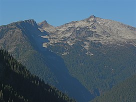
Mount Chaval is a craggy 7,127-foot (2,172-metre) mountain summit located in Skagit County of Washington state. Situated within the Glacier Peak Wilderness, Mount Chaval is positioned west of the crest of the North Cascades Range, approximately 15 miles northeast of the town of Darrington. It has two subsidiary peaks, East Peak and Middle Peak, each 7040 ft. The nearest higher neighbor is Snowking Mountain, 2.51 miles (4.04 km) to the northeast. Precipitation runoff from Mount Chaval drains into tributaries of the Skagit River.

Snowking Mountain is a 7,433-foot (2,266-metre) summit located in Skagit County of Washington state. Situated within the Glacier Peak Wilderness, Snowking Mountain is positioned west of the crest of the North Cascades, approximately 18 miles northeast of the town of Darrington. It is set within the Glacier Peak Wilderness, on land managed by Mount Baker–Snoqualmie National Forest. Snowking has two subsidiary peaks, West Peak (7,425 ft), and Middle Peak (7,400 ft). A broad unnamed glacier known colloquially as Snowking Glacier rests on the north face. Downslope of that glacier are Snowking Lake, Found Lake, and Cyclone Lake. Mount Tommy Thompson is three miles to the northwest, and the nearest higher neighbor is Mount Misch, 5.75 miles (9.25 km) to the southeast. Precipitation runoff from Snowking Mountain drains into tributaries of the Skagit River.

Big Devil Peak is a 7,055-foot-elevation mountain summit located in North Cascades National Park in Skagit County of Washington state. The peak lies midway between Marblemount and Newhalem and can be seen from the North Cascades Highway at the road pullout for Big Devil Falls. The peak rises 6,600+ feet above the valley floor at this viewing location in the valley. Big Devil is the highest peak of Teebone Ridge, and other peaks on this ridge include Little Devil Peak, Fallen Angel, and The Trapezoid. Precipitation runoff from the mountain drains into tributaries of the Skagit River.

Perdition Peak is a 7,675-foot (2,339-metre) mountain summit located in North Cascades National Park in Skagit County of Washington state. The peak lies 1.33 mi (2.14 km) northwest of Dorado Needle and 2.12 mi (3.41 km) northwest of Eldorado Peak. It can be seen from the North Cascades Highway west of Marblemount at a road pullout alongside the Skagit River. Perdition Peak is the highest peak of Backbone Ridge, and other peaks on this ridge include In Spirit Point, Cervical Point, Thoracic Point, Lumbar Point, The Sacrum, and The Coccyx. The first ascent of the peak was made on August 27, 1967, by John Roper via the serrated west ridge. Being a doctor, Roper named some of his many first ascents for anatomical parts of the body. Precipitation runoff and glacier meltwater from the mountain drains into tributaries of the Skagit River.

Dorado Needle is an 8,440+ ft mountain summit located in North Cascades National Park in Skagit County of Washington state. The peak lies 0.73 miles north of Eldorado Peak and 1.33 mi (2.14 km) southeast of Perdition Peak. It can be seen from the North Cascades Highway west of Marblemount at a road pullout along the Skagit River. The first ascent of the peak was made in July 1940 by Lloyd Anderson, Karl Boyer, and Tom Gorton via the Northwest Ridge. Precipitation runoff and glacier meltwater from the mountain drains into tributaries of the Skagit River.

The Triad is a mountain with three peaks located in the North Cascades, in Skagit County of Washington state. Situated in North Cascades National Park, The Triad is positioned west of the crest of the Cascade Range, approximately 12 miles east of the town of Marblemount. The middle peak (highest) has an elevation of 7,520+ ft, the west peak 7,440+ ft, and the east peak 7,520+ ft. The popular hiking objective, Hidden Lake Peak Lookout, lies three miles to the southwest, and the nearest higher peak, Eldorado Peak, two miles to the northeast, is a popular mountaineering objective. Precipitation runoff from The Triad drains into tributaries of the Cascade River which in turn is a tributary of the Skagit River. The first ascent of the mountain was made in 1949 by Dick Eilertsen, Dick Lowery, Dick Scales, and Don Wilde. This climbing party which had three identical first names, named it the Three Dicks. However, in the interest of good taste, the more suitable and similar name was adopted since "triad" means a group or set of three connected people or things.
Early Morning Spire is an 8,200-foot (2,499-metre) mountain summit located in North Cascades National Park, in Skagit County of Washington state. The peak lies 0.29 mi (0.47 km) west-northwest of Dorado Needle, 1.05 mi (1.69 km) north-northwest of Eldorado Peak and 1.08 mi (1.74 km) southeast of Perdition Peak. It can be seen from the North Cascades Highway, west of Marblemount at a road pullout alongside the Skagit River. The first ascent of the peak was made in 1971 by Richard Emerson and Tom Hornbein via the Southwest Face. They made a chilly bivouac near the summit, which is how the peak's name came to be. Precipitation runoff from the mountain drains into Marble Creek, a tributary of the Cascade River.

Slate Peak is a 7,440-foot (2,270-metre) mountain summit located on the shared border between Okanogan County and Whatcom County in Washington state. It is part of the Okanogan Range, which is a sub-range of the North Cascades. The mountain is situated 15 miles (24 km) northwest of Mazama, on the boundary line of the Pasayten Wilderness, on land managed by the Okanogan–Wenatchee National Forest. The peak has the distinction of having the highest road in Washington, as well as the highest fire lookout. Although the narrow one-lane white-knuckle road reaches the summit of the mountain, the Forest Service gated it to vehicles, which necessitates walking the final few hundred yards. Additionally, the Pacific Crest Trail traverses the west slope of the peak, and the West Fork Pasayten Trail traverses the eastern slope. The nearest higher peak is Devils Peak, 2.57 miles (4.14 km) to the north. Precipitation runoff from Slate Peak drains east into Pasayten River, or west into Slate Creek, which is in the Skagit River drainage basin.
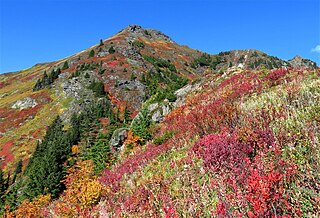
Sauk Mountain is a 5,545-foot (1,690-metre) mountain summit located in Skagit County of Washington state. It is situated immediately north of Rockport State Park and the North Cascades Highway, on land managed by the Mount Baker-Snoqualmie National Forest. Part of the North Cascades, Sauk Mountain is positioned west of the crest of the Cascade Range, approximately nine miles east of Concrete, Washington, and 17 miles north of the town of Darrington. The nearest higher peak is Helen Buttes, 5.86 miles (9.43 km) to the northeast. A popular two-mile trail provides hikers with good views from the craggy summit of Mount Baker, Mount Shuksan, Mount Chaval, and the Picket Range. Precipitation runoff from Sauk Mountain drains into tributaries of the Skagit River.
Yellow Aster Butte is a 6,241-foot (1,902-metre) Skagit Range summit located three miles south of the Canada–United States border, in Whatcom County of Washington state. It is situated within the Mount Baker Wilderness, on land managed by Mount Baker-Snoqualmie National Forest. The nearest higher neighbor is Winchester Mountain, 1.77 miles (2.85 km) to the east, and Mount Larrabee is set 2.3 miles (3.7 km) to the northeast. The summit offers views of Mount Larrabee, Tomyhoi Peak, American Border Peak, Canadian Border Peak, Mount Shuksan, and Mount Baker. Precipitation runoff on the north side of the mountain drains into Tomyhoi Creek, whereas the west side of the mountain drains into Damfino Creek, and the south slope is drained by Swamp Creek.

Lookout Mountain is a 5,699-foot (1,737 m) summit in the North Cascades, in Skagit County of Washington state. It is located five miles (8.0 km) east-northeast of the town of Marblemount, and set on land administered by the Mount Baker-Snoqualmie National Forest. The nearest higher neighbor is Teebone Ridge, two miles (3.2 km) to the east-northeast. At the top of Lookout Mountain is a historic US Forest Service lookout station that was built in 1962, which replaced a 1929 structure. Views from the top include Sauk Mountain to the west, with Eldorado Peak and the Picket Range in North Cascades National Park to the east and north respectively. The peak is just one mile outside the park boundary. Access is via a 4.7-mile (7.6 km) trail which gains over 4,400 feet (1,341 m) of elevation. Precipitation runoff from Lookout Mountain drains into tributaries of the Skagit River.

Mount Tommy Thompson is a 6,780-foot-elevation (2,070-meter) mountain summit located in Skagit County of Washington state. It is situated eight miles southeast of the town of Marblemount, within the Glacier Peak Wilderness, on land managed by Mount Baker–Snoqualmie National Forest, on the west slopes of the North Cascades Range. The nearest higher named neighbor is Snowking Mountain, 3.16 miles (5.09 km) to the southeast. Topographic relief is significant as the southwest aspect rises 3,670 feet above Slide Lake in less than two miles. Precipitation runoff from Mount Tommy Thompson drains into tributaries of the Skagit River.
Mount Watson is a 6,220-foot-elevation (1,900-meter) summit located in the North Cascades, in Whatcom County of Washington state.

Glee Peak is a 7,180-foot-elevation (2,190-meter) mountain summit located in Whatcom County of Washington state, United States. It is set within North Cascades National Park and Stephen Mather Wilderness, where it is situated 1.7 mile north of The Roost and one mile south of Azure Lake. The nearest higher neighbor is McMillan Spire, 1.7 miles (2.7 km) to the north-northwest. Glee Peak is part of the Picket Range which is a sub-range of the North Cascades, and like many North Cascades peaks, it is more notable for its large, steep rise above local terrain than for its absolute elevation. Topographic relief is significant as the northeast aspect rises 4,000 feet above Stetattle Creek in approximately one mile, and the southwest aspect rises 6,000 feet above Goodell Creek in three miles. Precipitation runoff from the mountain drains into these two creeks which are both tributaries of the Skagit River. Who made the first ascent of the summit is unknown, but Glee Davis and Burton Babcock were climbing in the immediate area as early as 1905.