Sahale Mountain is a jagged, glaciated mountain, in North Cascades National Park, in northern Washington state. The summit of Sahale Mountain is referred to as Sahale Peak. It is 0.3 miles (0.48 km) south of its higher neighbor, Boston Peak, and the saddle between the two is 80 feet (24 m) lower than Sahale's summit. Quien Sabe Glacier is to the west of the ridge between the two peaks while Davenport Glacier is in a cirque east of this ridge and above Horseshoe Basin. Sahale Glacier is south of the summit and east of Sahale Arm, a ridge that extends southwest from Sahale to Cascade Pass. The name Sahale may originate from a Northwest Native American word meaning "high place," "falcon," or "sacred."

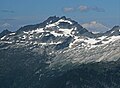
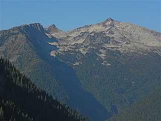
Buckner Mountain is a tall peak in the North Cascades of Washington state and in the Stephen Mather Wilderness of North Cascades National Park. At 9,114 feet (2,778 m) in elevation it is the highest in Skagit County and one of about ten of Washington's non-volcanic peaks above 9,000 feet high. It is ranked as the 14th highest peak in the state, and the third highest peak in North Cascades National Park.

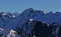
Mount Larrabee is a 7,865-foot (2,397-metre) Skagit Range mountain summit situated 1.4 mile south of the Canada–United States border, in the North Cascades of Washington state. It is located immediately southeast of American Border Peak within the Mount Baker Wilderness, which is part of the Mount Baker-Snoqualmie National Forest, and near North Cascades National Park. It is notable for its reddish coloring caused by oxidation of Iron in the rock. The rock consists of reddish interbedded and interfolded phyllites and greenstone. Originally known as Red Mountain, the name was changed in 1951 to honor Charles F. Larrabee (1895–1950), of the prominent Larrabee family of Bellingham, Washington. The toponym was officially adopted in 1951 by the U.S. Board on Geographic Names.

Fisher Peak is an 8,087-foot-elevation (2,465-meter) mountain summit located in the North Cascades of Washington state. It is situated on the boundaries of the Stephen Mather Wilderness and North Cascades National Park, midway between Black Peak and Easy Pass, and adjacent to Repulse Peak. Precipitation runoff from Fisher Peak's north and east slopes drains to Fisher Creek and Granite Creek which flow to the Skagit River, whereas the west slope drains into tributaries of the Stehekin River. Topographic relief is significant as the east aspect rises approximately 2,100 feet in less than one-half mile (0.8 km). The mountain's toponym has been officially adopted by the United States Board on Geographic Names.

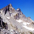
The Triplets is a 7,240+ ft summit located in Skagit County of Washington state. This breccia triple pinnacle is part of the North Cascades. The Triplets is situated above Cascade Pass on the shared border of North Cascades National Park and Glacier Peak Wilderness. The nearest higher neighbor is Cascade Peak, 0.35 miles (0.56 km) to the west-northwest. Surface runoff from the mountain drains into the Cascade River.

Mix-up Peak, also known as Mixup Peak, is a 7,440-foot (2,270-metre) mountain summit located on the shared boundary of Skagit County and Chelan County in Washington state. It is part of the North Cascades Range and is situated one mile south of Cascade Pass on the shared border of North Cascades National Park and Glacier Peak Wilderness. The nearest higher peak is Magic Mountain, 1.02 miles (1.64 km) to the east-southeast. Mix-up Peak is at the northern end of the Ptarmigan Traverse which is an alpine route to remote mountains such as Mount Formidable and Dome Peak. The Cache Glacier occupies a cirque below its eastern flank. Surface runoff on the east side the mountain drains into the Stehekin River, whereas precipitation runoff drains into the Cascade River from the west side.

Helen Buttes are two prominent summits near the western edge of the North Cascades, in Skagit County of Washington state. The buttes are located four miles northwest of Marblemount, Washington, in the Noisy-Diobsud Wilderness, on land administered by the Mount Baker-Snoqualmie National Forest. The nearest higher neighbor is Diobsud Buttes, 3.11 miles (5.01 km) to the north. Precipitation runoff from Helen Buttes drains into tributaries of the Skagit River.

Mount Misch is a remote 7,435 ft mountain summit in the North Cascades, in Skagit County of Washington state. It is the highest point of the Buckindy Range, or Buckindy Ridge. It is located 19 miles east-northeast of Darrington, Washington, and 15 miles north-northwest of Glacier Peak which is one of the Cascade stratovolcanoes. It is situated in the Glacier Peak Wilderness on land administered by the Mount Baker-Snoqualmie National Forest. Mount Misch was named by mountaineer and author Fred Beckey for his friend Peter Misch (1909-1987), University of Washington geology professor and mountaineer, who was renowned for his study of the North Cascades. Precipitation runoff from Mount Misch and the unnamed Goat Creek glacier on its east slope drains into tributaries of the Suiattle River and ultimately the Skagit River.

Snowking Mountain is a 7,433-foot (2,266-metre) summit located in Skagit County of Washington state. Situated within the Glacier Peak Wilderness, Snowking Mountain is positioned west of the crest of the North Cascades, approximately 18 miles northeast of the town of Darrington. It is set within the Glacier Peak Wilderness, on land managed by Mount Baker–Snoqualmie National Forest. Snowking has two subsidiary peaks, West Peak (7,425 ft), and Middle Peak (7,400 ft). A broad unnamed glacier known colloquially as Snowking Glacier rests on the north face. Downslope of that glacier are Snowking Lake, Found Lake, and Cyclone Lake. Mount Tommy Thompson is three miles to the northwest, and the nearest higher neighbor is Mount Misch, 5.75 miles (9.25 km) to the southeast. Precipitation runoff from Snowking Mountain drains into tributaries of the Skagit River.

Logger Butte is a 6,160-foot (1,878-metre) mountain summit near the western edge of the North Cascades, in Skagit County of Washington state. It is located north of Marblemount and Diobsud Buttes, on the shared boundary of North Cascades National Park and the Noisy-Diobsud Wilderness. The nearest higher peak is Electric Butte, 1.0 mi (1.6 km) to the north. Precipitation runoff from Logger Butte drains into tributaries of the Skagit River.

Perdition Peak is a 7,675-foot (2,339-metre) mountain summit located in North Cascades National Park in Skagit County of Washington state. The peak lies 1.33 mi (2.14 km) northwest of Dorado Needle and 2.12 mi (3.41 km) northwest of Eldorado Peak. It can be seen from the North Cascades Highway west of Marblemount at a road pullout alongside the Skagit River. Perdition Peak is the highest peak of Backbone Ridge, and other peaks on this ridge include In Spirit Point, Cervical Point, Thoracic Point, Lumbar Point, The Sacrum, and The Coccyx. The first ascent of the peak was made on August 27, 1967, by John Roper via the serrated west ridge. Being a doctor, Roper named some of his many first ascents for anatomical parts of the body. Precipitation runoff and glacier meltwater from the mountain drains into tributaries of the Skagit River.
Hagan Mountain is a multi-peak mountain located in Whatcom County, Washington state, within North Cascades National Park. It has an elevation of 7,080-feet (2,160-metres). The mountain is situated approximately 12 mi (19 km) north of Marblemount.

Dorado Needle is an 8,440+ ft mountain summit located in North Cascades National Park in Skagit County of Washington state. The peak lies 0.73 miles north of Eldorado Peak and 1.33 mi (2.14 km) southeast of Perdition Peak. It can be seen from the North Cascades Highway west of Marblemount at a road pullout along the Skagit River. The first ascent of the peak was made in July 1940 by Lloyd Anderson, Karl Boyer, and Tom Gorton via the Northwest Ridge. Precipitation runoff and glacier meltwater from the mountain drains into tributaries of the Skagit River.
Hidden Lake Peaks is series of peaks with a maximum elevation of 7,088 feet that are located in the North Cascades, in Skagit County of Washington state. The peaks extend three miles southwest from the nearest higher peak called The Triad. Situated on the western boundary of North Cascades National Park, Hidden Lake Peaks are positioned west of the crest of the Cascade Range, approximately ten miles east of the town of Marblemount. The popular subsidiary peak, Hidden Lake Lookout (6890 ft), lies a half mile to the southwest of the highest summit. The mountain's name is taken from its proximity to Hidden Lake which lies in a cirque below the east aspect of these two main peaks. Precipitation runoff from Hidden Lake Peaks drains into Cascade River which is a tributary of the Skagit River.
Early Morning Spire is an 8,200-foot (2,499-metre) mountain summit located in North Cascades National Park, in Skagit County of Washington state. The peak lies 0.29 mi (0.47 km) west-northwest of Dorado Needle, 1.05 mi (1.69 km) north-northwest of Eldorado Peak and 1.08 mi (1.74 km) southeast of Perdition Peak. It can be seen from the North Cascades Highway, west of Marblemount at a road pullout alongside the Skagit River. The first ascent of the peak was made in 1971 by Richard Emerson and Tom Hornbein via the Southwest Face. They made a chilly bivouac near the summit, which is how the peak's name came to be. Precipitation runoff from the mountain drains into Marble Creek, a tributary of the Cascade River.

Slate Peak is a 7,440-foot (2,270-metre) mountain summit located on the shared border between Okanogan County and Whatcom County in Washington state. It is part of the Okanogan Range, which is a sub-range of the North Cascades. The mountain is situated 15 miles (24 km) northwest of Mazama, on the boundary line of the Pasayten Wilderness, on land managed by the Okanogan–Wenatchee National Forest. The peak has the distinction of having the highest road in Washington, as well as the highest fire lookout. Although the narrow one-lane white-knuckle road reaches the summit of the mountain, the Forest Service gated it to vehicles, which necessitates walking the final few hundred yards. Additionally, the Pacific Crest Trail traverses the west slope of the peak, and the West Fork Pasayten Trail traverses the eastern slope. The nearest higher peak is Devils Peak, 2.57 miles (4.14 km) to the north. Precipitation runoff from Slate Peak drains east into Pasayten River, or west into Slate Creek, which is in the Skagit River drainage basin.
Sauk Mountain is a 5,545-foot (1,690-metre) mountain summit located in Skagit County of Washington state. It is situated immediately north of Rockport State Park and the North Cascades Highway, on land managed by the Mount Baker-Snoqualmie National Forest. Part of the North Cascades, Sauk Mountain is positioned west of the crest of the Cascade Range, approximately nine miles east of Concrete, Washington, and 17 miles north of the town of Darrington. The nearest higher peak is Helen Buttes, 5.86 miles (9.43 km) to the northeast. A popular two-mile trail provides hikers with good views from the craggy summit of Mount Baker, Mount Shuksan, Mount Chaval, and the Picket Range. Precipitation runoff from Sauk Mountain drains into tributaries of the Skagit River.

Lookout Mountain is a 5,699-foot (1,737 m) summit in the North Cascades, in Skagit County of Washington state. It is located five miles (8.0 km) east-northeast of the town of Marblemount, and set on land administered by the Mount Baker-Snoqualmie National Forest. The nearest higher neighbor is Teebone Ridge, two miles (3.2 km) to the east-northeast. At the top of Lookout Mountain is a historic US Forest Service lookout station that was built in 1962, which replaced a 1929 structure. Views from the top include Sauk Mountain to the west, with Eldorado Peak and the Picket Range in North Cascades National Park to the east and north respectively. The peak is just one mile outside the park boundary. Access is via a 4.7-mile (7.6 km) trail which gains over 4,400 feet (1,341 m) of elevation. Precipitation runoff from Lookout Mountain drains into tributaries of the Skagit River.

Mount Tommy Thompson is a 6,780-foot-elevation (2,070-meter) mountain summit located in Skagit County of Washington state. It is situated eight miles southeast of the town of Marblemount, within the Glacier Peak Wilderness, on land managed by Mount Baker–Snoqualmie National Forest, on the west slopes of the North Cascades Range. The nearest higher named neighbor is Snowking Mountain, 3.16 miles (5.09 km) to the southeast. Topographic relief is significant as the southwest aspect rises 3,670 feet above Slide Lake in less than two miles. Precipitation runoff from Mount Tommy Thompson drains into tributaries of the Skagit River.

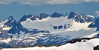
Glee Peak is a 7,180-foot-elevation (2,190-meter) mountain summit located in Whatcom County of Washington state, United States. It is set within North Cascades National Park and Stephen Mather Wilderness, where it is situated 1.7 mile north of The Roost and one mile south of Azure Lake. The nearest higher neighbor is McMillan Spire, 1.7 miles (2.7 km) to the north-northwest. Glee Peak is part of the Picket Range which is a sub-range of the North Cascades, and like many North Cascades peaks, it is more notable for its large, steep rise above local terrain than for its absolute elevation. Topographic relief is significant as the northeast aspect rises 4,000 feet above Stetattle Creek in approximately one mile, and the southwest aspect rises 6,000 feet above Goodell Creek in three miles. Precipitation runoff from the mountain drains into these two creeks which are both tributaries of the Skagit River. Who made the first ascent of the summit is unknown, but Glee Davis and Burton Babcock were climbing in the immediate area as early as 1905.