Big Devil Peak

Last updated
Big Devil Peak
Big Devil Peak from Snowfield.jpg
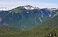
Big Devil Peak from the northeast
Highest point
Elevation 7,055 ft (2,150 m) [1]
Prominence 1,655 ft (504 m) [1]
Isolation 5.32 mi (8.56 km) [2]
Coordinates 48°36′16″N121°17′37″W / 48.60444°N 121.29361°W / 48.60444; -121.29361 [1]
Geography
USA Washington relief location map.jpg
Red triangle with thick white border.svg
Big Devil Peak
Location in Washington
Usa edcp relief location map.png
Red triangle with thick white border.svg
Big Devil Peak
Big Devil Peak (the United States)
Big Devil Peak
Interactive map of Big Devil Peak
CountryUnited States
State Washington
County Skagit
Protected area North Cascades National Park
Parent range North Cascades
Cascade Range
Topo map USGS Big Devil Peak
Geology
Rock type Gneiss, Schist
Climbing
First ascent 1963 J. Haggerty, J. Roper [3]
Easiest route Climbing YDS 3

Big Devil Peak is a 7,055-foot-elevation (2,150 meter) mountain summit located in North Cascades National Park in Skagit County of Washington state. The peak lies midway between Marblemount and Newhalem and can be seen from the North Cascades Highway at the road pullout for Big Devil Falls. The peak rises 6,600+ feet above the valley floor at this viewing location in the valley. Big Devil is the highest peak of Teebone Ridge, and other peaks on this ridge include Little Devil Peak, Fallen Angel, and The Trapezoid. Precipitation runoff from the mountain drains into tributaries of the Skagit River.

Contents

Climate

Big Devil Peak is located in the marine west coast climate zone of western North America. [4] Most weather fronts originate in the Pacific Ocean, and travel northeast toward the Cascade Mountains. As fronts approach the North Cascades, they are forced upward by the peaks of the Cascade Range (orographic lift), causing them to drop their moisture in the form of rain or snowfall onto the Cascades. As a result, the west side of the North Cascades experiences high precipitation, especially during the winter months in the form of snowfall. Because of maritime influence, snow tends to be wet and heavy, resulting in high avalanche danger. [4] During winter months, weather is usually cloudy, but due to high pressure systems over the Pacific Ocean that intensify during summer months, there is often little or no cloud cover during the summer. [4]

Geology

The North Cascades features some of the most rugged topography in the Cascade Range with craggy peaks, spires, ridges, and deep glacial valleys. Geological events occurring many years ago created the diverse topography and drastic elevation changes over the Cascade Range leading to the various climate differences.

The history of the formation of the Cascade Mountains dates back millions of years ago to the late Eocene Epoch. [5] With the North American Plate overriding the Pacific Plate, episodes of volcanic igneous activity persisted. [5] In addition, small fragments of the oceanic and continental lithosphere called terranes created the North Cascades about 50 million years ago. [5]

During the Pleistocene period dating back over two million years ago, glaciation advancing and retreating repeatedly scoured the landscape leaving deposits of rock debris. [5] The U-shaped cross section of the river valleys is a result of recent glaciation. Uplift and faulting in combination with glaciation have been the dominant processes which have created the tall peaks and deep valleys of the North Cascades area.

See also

Related Research Articles

<span class="mw-page-title-main">Graybeard Peak</span> Mountain in Washington (state), United States

Graybeard Peak is a 7,965-foot (2,428-metre) mountain summit located in Skagit County, Washington.

<span class="mw-page-title-main">Icy Peak</span> Mountain in Washington (state), United States

Icy Peak is a 7,073-foot (2,156-metre) Skagit Range mountain summit located in the North Cascades of Washington state. It is situated in North Cascades National Park at the head of Nooksack Cirque. High ridges connect it to Seahpo Peak and Mount Shuksan. An icefall occupies the northeast cirque, and small glaciers clad all sides of the peak. Precipitation runoff drains into the Nooksack and Baker Rivers.

<span class="mw-page-title-main">Azurite Peak</span> Mountain in Washington (state), United States

Azurite Peak is an 8,434-foot (2,571-metre) double-summit mountain located at the common boundary point of Okanogan County, Skagit County, and Whatcom County in Washington state. It is part of the Okanogan Range which is a sub-range of the North Cascades Range. Azurite Peak ranks as the 81st-highest summit in the state. Azurite Peak is situated north of Azurite Pass on land administered by the Okanogan–Wenatchee National Forest. The nearest higher neighbor is Tower Mountain, 5.24 miles (8.43 km) to the south-southeast, and Mount Ballard lies 1.97 miles (3.17 km) to the north. Remnants of a small pocket glacier are found on the east aspect. Precipitation runoff from the peak drains north into tributaries of the Skagit River, and south into the Methow River. Topographic relief is significant as the summit rises over 3,000 feet above Mill Creek in one mile (1.6 km). The Pacific Crest Trail traverses the base of Azurite Peak.

<span class="mw-page-title-main">Repulse Peak</span> Mountain in Washington (state), United States

Repulse Peak is a 7,923-foot (2,415-metre) mountain summit in the North Cascades in the U.S. state of Washington. It is located on the border of the Stephen Mather Wilderness and North Cascades National Park. It is situated midway between Black Peak and Fisher Peak, and can be seen from the North Cascades Highway. Precipitation runoff from Repulse Peak drains into tributaries of the Skagit River and Stehekin River. Topographic relief is significant as the east face rises over 2,900 feet in 0.53 mile (0.85 km).

<span class="mw-page-title-main">Porcupine Peak (Washington)</span> Mountain in Washington (state), United States

Porcupine Peak is a 7,762-foot-elevation (2,366-meter) mountain located in Skagit County of Washington state.

<span class="mw-page-title-main">Blackbeard Peak</span> Mountain in Washington (state), United States

Blackbeard Peak, also spelled Black Beard Peak, is a 7,241-foot mountain summit in the North Cascades in the U.S. state of Washington. It is located in the Okanogan–Wenatchee National Forest in Skagit County. It is situated northwest of Rainy Pass, southwest of Porcupine Peak, and southeast of Graybeard Peak. Its nearest higher neighbor is Repulse Peak, 1.06 mi (1.71 km) to the west. Blackbeard Peak can be seen from the North Cascades Highway. Precipitation runoff from Blackbeard Peak drains into Granite Creek, a tributary of the Skagit River. Topographic relief is significant as the summit rises over 3,000 feet above Granite Creek in one mile (1.6 km).

<span class="mw-page-title-main">Crooked Bum</span> Mountain in Washington (state), United States

Crooked Bum is a 6,937-foot-elevation mountain summit on the crest of the North Cascades in the U.S. state of Washington. It is located in the Okanogan–Wenatchee National Forest on the shared border of Skagit County and Chelan County. It is situated immediately west of Rainy Pass and two miles east of Corteo Peak. The scenic and popular Maple Pass Trail traverses the south slope of the peak while staying above Lake Ann. Precipitation runoff from the north slope of Crooked Bum drains into Granite Creek which is a tributary of the Skagit River, whereas the south side drains into Bridge Creek which is a tributary of the Chelan River.

<span class="mw-page-title-main">Red Mountain (Skagit County, Washington)</span> Mountain in Washington (state), United States

Red Mountain is a 7,662-foot (2,335-metre) summit in the North Cascades of Washington, United States. It is located in Skagit County, within North Cascades National Park and the Stephen Mather Wilderness. It is situated on a smooth ridge of brick-red color at the western culmination of Ragged Ridge. The nearest higher peak is Cosho Peak, 2.6 miles (4.2 km) to the east-southeast.

<span class="mw-page-title-main">Mount Misch</span> Mountain in Washington (state), United States

Mount Misch is a remote 7,435 ft mountain summit in the North Cascades, in Skagit County of Washington state. It is the highest point of the Buckindy Range, or Buckindy Ridge. It is located 19 miles east-northeast of Darrington, Washington, and 15 miles north-northwest of Glacier Peak which is one of the Cascade stratovolcanoes. It is situated in the Glacier Peak Wilderness on land administered by the Mount Baker-Snoqualmie National Forest. Mount Misch was named by mountaineer and author Fred Beckey for his friend Peter Misch (1909-1987), University of Washington geology professor and mountaineer, who was renowned for his study of the North Cascades. Precipitation runoff from Mount Misch and the unnamed Goat Creek glacier on its east slope drains into tributaries of the Suiattle River and ultimately the Skagit River.

<span class="mw-page-title-main">Mount Chaval</span> Mountain in Washington (state), United States

Mount Chaval is a craggy 7,127-foot (2,172-metre) mountain summit located in Skagit County of Washington state. Situated within the Glacier Peak Wilderness, Mount Chaval is positioned west of the crest of the North Cascades Range, approximately 15 miles northeast of the town of Darrington. It has two subsidiary peaks, East Peak and Middle Peak, each 7040 ft. The nearest higher neighbor is Snowking Mountain, 2.51 miles (4.04 km) to the northeast. Precipitation runoff from Mount Chaval drains into tributaries of the Skagit River.

<span class="mw-page-title-main">Snowking Mountain</span> Mountain in Washington (state), United States

Snowking Mountain is a 7,433-foot (2,266-metre) summit located in Skagit County of Washington state. Situated within the Glacier Peak Wilderness, Snowking Mountain is positioned west of the crest of the North Cascades, approximately 18 miles northeast of the town of Darrington. It is set within the Glacier Peak Wilderness, on land managed by Mount Baker–Snoqualmie National Forest. Snowking has two subsidiary peaks, West Peak (7,425 ft), and Middle Peak (7,400 ft). A broad unnamed glacier known colloquially as Snowking Glacier rests on the north face. Downslope of that glacier are Snowking Lake, Found Lake, and Cyclone Lake. Mount Tommy Thompson is three miles to the northwest, and the nearest higher neighbor is Mount Misch, 5.75 miles (9.25 km) to the southeast. Precipitation runoff from Snowking Mountain drains into tributaries of the Skagit River.

<span class="mw-page-title-main">The Chopping Block (Washington)</span> Mountain in Washington (state), United States

The Chopping Block is a 6,819-foot (2,078-metre) mountain summit located in the Picket Range within North Cascades National Park in the state of Washington. The mountain is officially named Pinnacle Peak on maps, but hardly anyone calls it by that name. The nearest higher peak is Mount Degenhardt, 0.6 mi (0.97 km) to the northeast. The Chopping Block can be seen from the North Cascades National Park Newhalem visitor center, weather permitting. Precipitation runoff from the peak drains into Goodell Creek, a tributary of the Skagit River.

<span class="mw-page-title-main">Perdition Peak</span> Mountain in Washington (state), United States

Perdition Peak is a 7,675-foot (2,339-metre) mountain summit located in North Cascades National Park in Skagit County of Washington state. The peak lies 1.33 mi (2.14 km) northwest of Dorado Needle and 2.12 mi (3.41 km) northwest of Eldorado Peak. It can be seen from the North Cascades Highway west of Marblemount at a road pullout alongside the Skagit River. Perdition Peak is the highest peak of Backbone Ridge, and other peaks on this ridge include In Spirit Point, Cervical Point, Thoracic Point, Lumbar Point, The Sacrum, and The Coccyx. The first ascent of the peak was made on August 27, 1967, by John Roper via the serrated west ridge. Being a doctor, Roper named some of his many first ascents for anatomical parts of the body. Precipitation runoff and glacier meltwater from the mountain drains into tributaries of the Skagit River.

<span class="mw-page-title-main">Dorado Needle</span> Mountain in Washington (state), United States

Dorado Needle is an 8,440+ ft mountain summit located in North Cascades National Park in Skagit County of Washington state. The peak lies 0.73 miles north of Eldorado Peak and 1.33 mi (2.14 km) southeast of Perdition Peak. It can be seen from the North Cascades Highway west of Marblemount at a road pullout along the Skagit River. The first ascent of the peak was made in July 1940 by Lloyd Anderson, Karl Boyer, and Tom Gorton via the Northwest Ridge. Precipitation runoff and glacier meltwater from the mountain drains into tributaries of the Skagit River.

<span class="mw-page-title-main">Early Morning Spire</span> Mountain in Washington (state), United States

Early Morning Spire is an 8,200-foot (2,499-metre) mountain summit located in North Cascades National Park, in Skagit County of Washington state. The peak lies 0.29 mi (0.47 km) west-northwest of Dorado Needle, 1.05 mi (1.69 km) north-northwest of Eldorado Peak and 1.08 mi (1.74 km) southeast of Perdition Peak. It can be seen from the North Cascades Highway, west of Marblemount at a road pullout alongside the Skagit River. The first ascent of the peak was made in 1971 by Richard Emerson and Tom Hornbein via the Southwest Face. They made a chilly bivouac near the summit, which is how the peak's name came to be. Precipitation runoff from the mountain drains into Marble Creek, a tributary of the Cascade River.

<span class="mw-page-title-main">Mount Chardonnay</span> Mountain in Washington (state), United States

Mount Chardonnay is a prominent 7,020+ ft mountain summit located in the Skagit Range, which is a subset of the North Cascades in Whatcom County of Washington state. It is situated 1.7 mi (2.7 km) north of Granite Mountain and 2.75 mi (4.43 km) east of Goat Mountain in the Mount Baker Wilderness, which is managed by the Mount Baker-Snoqualmie National Forest. The nearest higher peak is Mount Sefrit, 2.77 mi (4.46 km) to the southwest. Precipitation runoff from the mountain drains into Silesia Creek, a tributary of the Fraser River.

<span class="mw-page-title-main">Skagit Peak</span> Mountain in Washington (state), United States

Skagit Peak is a 6,824-foot (2,080-metre) mountain summit located in the North Cascades, in Whatcom County of Washington state. It is situated on the western side of the Cascade crest, at the western edge of the Pasayten Wilderness, on land managed by the Okanogan–Wenatchee National Forest. Skagit Peak is part of the Hozameen Range, a subset of the North Cascades which also includes Hozomeen Mountain to the north, and Jack Mountain to the south. Precipitation runoff from this mountain drains into the Skagit River via Three Fools Creek and Ross Lake.

<span class="mw-page-title-main">Jackita Ridge</span> Ridge in Washington state, US

Jackita Ridge is a 7,350-foot (2,240-metre) ridge located in the Pasayten Wilderness, in Whatcom County of Washington state. It is part of the Hozameen Range which is a subset of the North Cascades. The highest point is called Jackita Peak, and the Jackita Ridge Trail traverses below the west aspect of this summit, providing access for an off-trail scramble to the top. The nearest higher neighbor is Crater Mountain, 3.9 miles (6.3 km) to the southwest, Jack Mountain is set 4.77 miles (7.68 km) to the west, and McKay Ridge is 5.7 miles (9.2 km) to the south. Precipitation runoff from this ridge drains to Ross Lake via Devils Creek and Canyon Creek, which are part of the Skagit River drainage basin. The first ascent may have been made in 1926 by the United States Coast and Geodetic Survey, which placed a Jackita benchmark.

<span class="mw-page-title-main">Mount Tommy Thompson</span> Mountain in Washington (state), United States

Mount Tommy Thompson is a 6,780-foot-elevation (2,070-meter) mountain summit located in Skagit County of Washington state. It is situated eight miles southeast of the town of Marblemount, within the Glacier Peak Wilderness, on land managed by Mount Baker–Snoqualmie National Forest, on the west slopes of the North Cascades Range. The nearest higher named neighbor is Snowking Mountain, 3.16 miles (5.09 km) to the southeast. Topographic relief is significant as the southwest aspect rises 3,670 feet above Slide Lake in less than two miles. Precipitation runoff from Mount Tommy Thompson drains into tributaries of the Skagit River.

<span class="mw-page-title-main">Little Devil Peak</span> Mountain in Skagit County, Washington, United States

Little Devil Peak is a 6,985-foot-elevation (2,129 m) mountain summit located in Skagit County of Washington state. It is set within North Cascades National Park and Stephen Mather Wilderness, where it is situated 3.1 miles northeast of Lookout Mountain. Little Devil is the second-highest peak of Teebone Ridge, and other peaks on this ridge include line parent Big Devil Peak, Fallen Angel, and The Trapezoid. Precipitation runoff from the mountain drains into tributaries of the Skagit River. Like many North Cascades peaks, it is more notable for its large, steep rise above local terrain than for its absolute elevation. Topographic relief is significant as the south aspect rises 5,400 feet above Marble Creek in three miles, and the east aspect rises 4,200 feet above Newhalem Creek in approximately 1.5 mile.

References

  1. 1 2 3 "Big Devil Peak, Washington". Peakbagger.com.
  2. "Big Devil Peak - 7,055' WA". Lists of John. Retrieved 2021-01-30.
  3. Kenn Carpenter (1966) American Alpine Journal
  4. 1 2 3 Beckey, Fred W. Cascade Alpine Guide, Climbing and High Routes. Seattle, WA: Mountaineers Books, 2008.
  5. 1 2 3 4 Kruckeberg, Arthur (1991). The Natural History of Puget Sound Country. University of Washington Press.