Chatfield Hollow State Park is a public recreation area occupying 412 acres (167 ha) that lie adjacent to Cockaponset State Forest in the town of Killingworth, Connecticut. The state park offers hiking trails, a swimming beach, trout fishing, mountain biking, rock climbing, and picnicking areas. Park attractions include 6.67-acre (2.70 ha) Schreeder Pond, Indian caves, historic sites, a restored water wheel, and a reproduction covered bridge. The park is managed by the Connecticut Department of Energy and Environmental Protection.

Starved Rock State Park is a state park in the U.S. state of Illinois, characterized by the many canyons within its 2,630 acres (1,064 ha). Located just southeast of the village of Utica, in Deer Park Township, LaSalle County, Illinois, along the south bank of the Illinois River, the park hosts over two million visitors annually, the most for any Illinois state park.

Walnut Canyon National Monument is a United States National Monument located about 10 mi (16 km) southeast of downtown Flagstaff, Arizona, near Interstate 40. The canyon rim elevation is 6,690 ft (2,040 m); the canyon's floor is 350 ft lower. A 0.9 mi (1.4 km) long loop trail descends 185 ft (56 m) into the canyon passing 25 cliff dwelling rooms constructed by the Sinagua, a pre-Columbian cultural group that lived in Walnut Canyon from about 1100 to 1250 AD. Other contemporary habitations of the Sinagua people are preserved in the nearby Tuzigoot and Montezuma Castle national monuments.

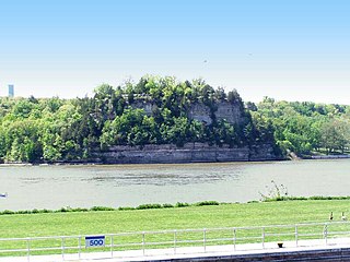
Sugar Loaf is a bluff on the Mississippi River topped by a rock pinnacle, overlooking the city of Winona, Minnesota, United States. The name "Sugar Loaf" is sometimes taken to mean just the rock pinnacle, which was created by quarrying in the 19th century. The bluff stands above the junction of U.S. Route 61 and State Highway 43. It towers 500 feet (150 m) over Lake Winona, and the pinnacle rises more than 85 feet (26 m) above the remainder of the bluff.

Tishomingo State Park is a public recreation area located in the foothills of the Appalachian Mountains in Tishomingo County, some 45 miles (72 km) northeast of Tupelo, Mississippi. The major feature of the park is Bear Creek Canyon and its generous sandstone outcroppings. Activities in the park include canoeing, rock climbing, fishing, and hiking. The park sits at Milepost 304 of Natchez Trace Parkway, a scenic road operated by the National Park Service commemorating the historical Natchez Trace.

White Pines Forest State Park, more commonly referred to as White Pines State Park, is an Illinois state park in Ogle County, Illinois. It is located near the communities of Polo, Mount Morris and Oregon. The 385-acre (156 ha) park contains the southernmost remaining stand of native white pine trees in the state of Illinois, and that area, 43 acres (17 ha), was designated an Illinois Nature Preserve in 2001.

Kooser State Park is a 250-acre (101 ha) Pennsylvania state park in Jefferson Township, Somerset County, Pennsylvania, in the United States. The park, which borders Forbes State Forest, was built in the 1930s by the Civilian Conservation Corps, who also built the 4-acre (1.6 ha) Kooser Lake by damming Kooser Run. Kooser State Park is on Pennsylvania Route 31 a one-hour drive from Pittsburgh. The park is surrounded by Forbes State Forest.

The Wolfe Ranch, also known as Turnbow Cabin, is located in Arches National Park near Moab, Utah, United States.

Westmoreland State Park lies within Westmoreland County, Virginia. The park extends about one and a half miles along the Potomac River. The park covers 1,321 acres. The park's Horsehead Cliffs provide visitors with a panoramic view of the Potomac River. The park offers hiking, camping, cabins, fishing, boating and swimming.

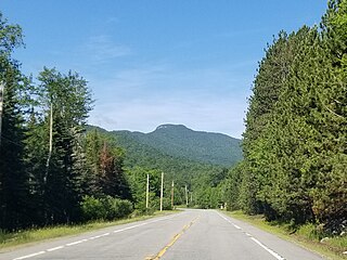
Snowy Mountain is a mountain located in Hamilton County, New York. Initially known as 'Squaw Bonnet', its summit is the highest point in the county. While most maps show the elevation as 3899 feet, some suggest that more recent surveys have it as 3904 feet or even 3908 feet.

Curry Village is a resort in Mariposa County, California in Yosemite National Park within the Yosemite Valley.

The Cliffs Ranger Station is an early United States Forest Service ranger station in what is now Walnut Canyon National Monument in northern Arizona, United States. Also known as the Old Headquarters of the national monument, it was built in 1904 by the Forest Service, and served as the monument headquarters after it was established in 1915. The log cabin is one of the oldest remaining log cabins in northern Arizona. It served as the living quarters for the park's early custodians. The cabin measures 45 ft (14 m) by 15 ft (4.6 m) overall, including an addition at the east end. The roof overhang of the addition has been cut back to allow an alligator cypress to grow close to the building. The interior is divided into four rooms.

Rosemont is an unincorporated community located within Delaware Township in Hunterdon County, New Jersey, United States. Its ZIP code is 08556. Located at the top of a small hill, the center of the community is located along Kingwood Stockton Road near its intersections with Raven Rock Rosemont Road and Rosemont Ringoes Road. Farmland and residences make up the surrounding area while the center of the settlement includes residences, a post office, and an antique shop.

The Wreckage is a log house in Ocean Park, Washington, constructed of unhewn logs in 1912. The house was built by author Guy S. Allison on the Long Beach Peninsula as a beach house, using salvaged materials. Recovering driftwood from the Pacific Ocean, Allison also made what he called a "zoo" of driftwood animal shapes surrounding the house that appear on U.S. Geological Survey maps as "Wreckage Park Zoo." The collection was featured in Ripley's Believe It or Not! and Strange as it Seems.

The Sourdough Mountain Lookout is a fire lookout that was built by the Civilian Conservation Corps in 1933. Constructed atop Sourdough Mountain in North Cascades National Park, in the U.S. state of Washington, the lookout was placed on the National Register of Historic Places in 1989.

The Backus-Marblemount Ranger Station House No. 1009 is in Mount Baker-Snoqualmie National Forest, in the U.S. state of Washington. Constructed by the United States Forest Service in 1932, the ranger station was inherited by the National Park Service when North Cascades National Park was dedicated in 1968. The ranger station was placed on the National Register of Historic Places in 1989.

The Beaver Pass Shelter is in North Cascades National Park, in the U.S. state of Washington. Constructed by the United States Forest Service in 1938, the shelter was inherited by the National Park Service when North Cascades National Park was dedicated in 1968. Beaver Pass Shelter was placed on the National Register of Historic Places in 1989.

The Perry Creek Shelter is in North Cascades National Park, in the U.S. state of Washington. Constructed by United States Forest Service employee Fred Berry in 1937, the shelter was inherited by the National Park Service when North Cascades National Park was dedicated in 1968. The shelter was placed on the National Register of Historic Places in 1989.

The Swamp–Meadow Cabin (west) is in North Cascades National Park, in the U.S. state of Washington. Constructed sometime in the early 1910s by the North Coast Mining and Milling Company, the cabin was a warm season residence used by company employees for storage and residence while working their mining claims on Thunder Creek. The 1 1⁄2-story cabin was constructed plainly of 16 in (410 mm) round hewn logs, square notched at the corners. The cabin is 18 by 22 ft with an offset door at the east end, above which it is sheltered by the 10 ft (3.0 m) extension of the gable roof which is wood shingled. Swamp–Meadow Cabin (west) is near Swamp–Meadow Cabin (east), and both were placed on the National Register of Historic Places in 1989.


