Hamilton, Washington

Last updated

Hamilton
Hamilton, Washington
Brick Building in Hamilton WA.jpg
Skagit County Washington Incorporated and Unincorporated areas Hamilton Highlighted.svg
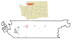
Location of Hamilton, Washington
Coordinates: 48°31′34″N121°59′20″W / 48.52611°N 121.98889°W / 48.52611; -121.98889
Country United States
State Washington
County Skagit
Area
[1]
  Total1.20 sq mi (3.10 km2)
  Land1.20 sq mi (3.10 km2)
  Water0.00 sq mi (0.00 km2)
Elevation
95 ft (29 m)
Population
 (2020) [2]
  Total299
  Estimate 
(2019) [3]
310
  Density258.98/sq mi (100.01/km2)
Time zone UTC-8 (Pacific (PST))
  Summer (DST) UTC-7 (PDT)
ZIP code
98255
Area code 360
FIPS code 53-29255 [4]
GNIS feature ID1520479 [5]

Hamilton is a town in Skagit County, Washington, United States. The population was 299 at the 2020 census. It is included in the Mount Vernon-Anacortes, Washington Metropolitan Statistical Area.

Contents

History

Hamilton was first settled in 1877 by William Hamilton, and was later named for him when Hamilton was officially incorporated on March 19, 1891. [6] [7]

The town was flooded by the Skagit River in November 2021. The local post office was deemed uninhabitable due to damage from the floods and shut down despite repairs to the building. Mail and parcels bound for Hamilton are instead forwarded to the Concrete post office, located 13 miles (21 km) away, despite protests from residents. [8]

Geography

Hamilton is located at 48°31′34″N121°59′20″W / 48.52611°N 121.98889°W / 48.52611; -121.98889 (48.526005, -121.988958). [9]

According to the United States Census Bureau, the town has a total area of 1.13 square miles (2.93 km2), all of it land. [10]

Flooding

As part of the Skagit River floodway, the town of Hamilton faces significant flooding every few years, most notably in 2003, 2006, 2017, and 2021. [11] The frequent flooding has forced residents to adopt a routine of moving their furniture from the ground floor and evacuating to a local church until the waters recede. The Federal Emergency Management Agency (FEMA) estimates it has spent $4.6 million in the town over the last several years. [11]

Support has been building for a plan to move the entire town to a nearby hill. The Hamilton Public Development Authority was established in 2004 to purchase the land necessary for moving the town, which was achieved with assistance from conservation group Forterra in 2018. Forterra purchased a 45-acre (18 ha) farm north of State Route 20, which it aims to develop into a green city with housing for the relocated townspeople. [11]

Climate

The climate in this area has mild differences between highs and lows, and there is adequate rainfall year-round. According to the Köppen Climate Classification system, Hamilton has a marine west coast climate, abbreviated "Cfb" on climate maps. [12]

Demographics

Historical population
CensusPop.Note
1890 203
1900 39293.1%
1910 4053.3%
1920 46214.1%
1930 252−45.5%
1940 229−9.1%
1950 29428.4%
1960 271−7.8%
1970 196−27.7%
1980 26836.7%
1990 228−14.9%
2000 30935.5%
2010 301−2.6%
2020 299−0.7%
2019 (est.)310 [3] 3.0%
U.S. Decennial Census [13]
2015 Estimate [14]

2010 census

As of the census [2] of 2010, there were 301 people, 116 households, and 80 families living in the town. The population density was 266.4 inhabitants per square mile (102.9/km2). There were 141 housing units at an average density of 124.8 per square mile (48.2/km2). The racial makeup of the town was 90.4% White, 2.0% Native American, 3.7% from other races, and 4.0% from two or more races. Hispanic or Latino of any race were 4.3% of the population.

There were 116 households, of which 31.9% had children under the age of 18 living with them, 51.7% were married couples living together, 9.5% had a female householder with no husband present, 7.8% had a male householder with no wife present, and 31.0% were non-families. 19.0% of all households were made up of individuals, and 1.7% had someone living alone who was 65 years of age or older. The average household size was 2.59 and the average family size was 2.99.

The median age in the town was 40.5 years. 23.9% of residents were under the age of 18; 9.6% were between the ages of 18 and 24; 25.9% were from 25 to 44; 30.5% were from 45 to 64; and 10% were 65 years of age or older. The gender makeup of the town was 48.5% male and 51.5% female.

2000 census

As of the census [4] of 2000, there were 309 people, 117 households, and 80 families living in the town. The population density was 313.2 people per square mile (120.5/km2). There were 135 housing units at an average density of 136.8 per square mile (52.7/km2). The racial makeup of the town was 91.91% White, 3.56% Native American, 0.65% Asian, 1.62% from other races, and 2.27% from two or more races. Hispanic or Latino of any race were 2.91% of the population.

There were 117 households, out of which 35.0% had children under the age of 18 living with them, 47.0% were married couples living together, 11.1% had a female householder with no husband present, and 30.8% were non-families. 20.5% of all households were made up of individuals, and 2.6% had someone living alone who was 65 years of age or older. The average household size was 2.64 and the average family size was 2.91.

In the town, the age distribution of the population shows 27.8% under the age of 18, 6.1% from 18 to 24, 34.3% from 25 to 44, 23.6% from 45 to 64, and 8.1% who were 65 years of age or older. The median age was 36 years. For every 100 females, there were 127.2 males. For every 100 females age 18 and over, there were 123.0 males.

The median income for a household in the town was $31,500, and the median income for a family was $34,063. Males had a median income of $33,542 versus $22,969 for females. The per capita income for the town was $13,531. About 21.2% of families and 22.8% of the population were below the poverty line, including 28.0% of those under the age of eighteen and none of those 65 or over.

Related Research Articles

<span class="mw-page-title-main">Knightsville, Indiana</span> Town in Indiana, United States

Knightsville is a town in Van Buren Township, Clay County, Indiana, United States. The population was 872 at the 2010 census. It is part of the Terre Haute Metropolitan Statistical Area.

Springfield is a town in Penobscot County, Maine, United States. The population was 293 at the 2020 census.

<span class="mw-page-title-main">Maxwell, Nebraska</span> Village in Lincoln County, Nebraska, United States

Maxwell is a village in Lincoln County, Nebraska, United States. It is part of the North Platte Micropolitan Statistical Area. The population was 312 at the 2010 census.

<span class="mw-page-title-main">Sasakwa, Oklahoma</span> Town in Oklahoma, United States

Sasakwa is a town in Seminole County, Oklahoma, United States. The population was documented as 150 in both the 2010 and 2000 census.

<span class="mw-page-title-main">Coupeville, Washington</span> Town in Washington, United States

Coupeville is a town on Whidbey Island, in Island County, Washington, United States.

<span class="mw-page-title-main">Conconully, Washington</span> Town in Washington, United States

Conconully is a town in Okanogan County, Washington, United States. The population was 210 at the 2010 census.

<span class="mw-page-title-main">Burlington, Washington</span> City in Washington, United States

Burlington is a city in Skagit County, Washington, United States. Its population was recorded as 9,152 in the 2020 census. Burlington is located approximately halfway between Seattle and Vancouver, B.C. The city is included in the Mount Vernon–Anacortes, Washington Metropolitan Statistical Area.

<span class="mw-page-title-main">Concrete, Washington</span> Town in Washington, United States

Concrete is a town in north-central Skagit County, Washington, United States. It is part of the Mount Vernon-Anacortes, Washington Metropolitan Statistical Area, and had a population of 705 at the 2010 census.

<span class="mw-page-title-main">Lyman, Washington</span> Town in Washington, United States

Lyman is a town in Skagit County, Washington, United States. The population was 438 at the 2010 census. It is included in the Mount Vernon-Anacortes, Washington Metropolitan Statistical Area.

<span class="mw-page-title-main">Mount Vernon, Washington</span> City in Washington, United States

Mount Vernon is the county seat of Skagit County, Washington, United States. The population was 35,219 at the 2020 census. It is one of two principal cities of and included in the Mount Vernon-Anacortes, Washington Metropolitan Statistical Area. Downtown Mount Vernon is known for its annual Tulip Festival Street Fair, which is part of the Skagit Valley Tulip Festival. The climate of Skagit County is similar to that of Northern France, with millions of tulips grown in the Skagit Valley. In 1998, Mount Vernon was rated the #1 "Best City in America" by the New Rating Guide to Life in America's Small Cities.

<span class="mw-page-title-main">Rockport, Washington</span> CDP in Washington, United States

Rockport is a census-designated place (CDP) in Skagit County, Washington, United States. The population was 109 at the 2010 census. It is included in the Mount Vernon–Anacortes, Washington Metropolitan Statistical Area.

<span class="mw-page-title-main">Sedro-Woolley, Washington</span> City in Washington, United States

Sedro-Woolley is a city in Skagit County, Washington, United States. It is part of the Mount Vernon–Anacortes, Washington Metropolitan Statistical Area and had a population of 12,421 at the 2020 census. The city is home to North Cascades National Park.

<span class="mw-page-title-main">Man, West Virginia</span> Town in West Virginia, United States

Man is a town in Logan County, West Virginia, United States. The population was 759 at the 2010 census. The town is located along the Guyandotte River at the mouth of Buffalo Creek, which was the site of the 1972 Buffalo Creek Flood following a dam collapse. The name of the town reportedly derives from the last syllable of the surname of Ulysses Hinchman, who was a member of the House of Delegates from Logan County between 1866 and 1869.

<span class="mw-page-title-main">Iaeger, West Virginia</span> Town in West Virginia, United States

Iaeger is a town in McDowell County, West Virginia, United States. The population was 257 at the 2020 census.

<span class="mw-page-title-main">Matoaka, West Virginia</span> Census-designated place in West Virginia, United States

Matoaka is a census-designated place in Mercer County, West Virginia, United States. The population was 227 at the 2010 census. It is part of the Bluefield, WV-VA micropolitan area which has a population of 107,578. This town is named for Chief Powhatan's daughter Matoaka who was better known by her nickname "Pocahontas". Matoaka became an unincorporated town when it voted to dissolve its charter in May 2018.

<span class="mw-page-title-main">Albright, West Virginia</span> Town in West Virginia, United States

Albright is a town in central Preston County, West Virginia, United States, along the Cheat River. The population was 260 at the 2020 census. A former coal town, it is part of the Morgantown metropolitan area.

<span class="mw-page-title-main">Bruceton Mills, West Virginia</span> Town in West Virginia, United States

Bruceton Mills is a town in northern Preston County, West Virginia, United States, along Big Sandy Creek. The population was 64 at the 2020 census, making it the second-least populous town in West Virginia, after Thurmond. It is part of the Morgantown metropolitan area.

<span class="mw-page-title-main">Rowlesburg, West Virginia</span> Town in West Virginia, United States

Rowlesburg is a town in southern Preston County, West Virginia, United States, along the Cheat River. The population was 438 at the 2020 census. It is part of the Morgantown metropolitan area. A former railroad town, it is home to the Downtown Rowlesburg Historic District, and was the site of action during the American Civil War.

<span class="mw-page-title-main">Cairo, West Virginia</span> Town in West Virginia, United States

Cairo is a town in Ritchie County, West Virginia, United States, along West Virginia Route 31, the North Fork of the Hughes River, and the North Bend Rail Trail. The population was 174 at the 2020 census.

<span class="mw-page-title-main">Parsons, West Virginia</span> City in West Virginia, United States

Parsons is the largest city in and county seat of Tucker County, West Virginia, United States. The population was 1,322 at the 2020 census. Parsons is located at the confluence of the Shavers Fork and the Black Fork, forming the head of the Cheat River.

References

  1. "2019 U.S. Gazetteer Files". United States Census Bureau. Retrieved August 7, 2020.
  2. 1 2 "U.S. Census website". United States Census Bureau . Retrieved December 19, 2012.
  3. 1 2 "Population and Housing Unit Estimates". United States Census Bureau. May 24, 2020. Retrieved May 27, 2020.
  4. 1 2 "U.S. Census website". United States Census Bureau . Retrieved January 31, 2008.
  5. "US Board on Geographic Names". United States Geological Survey. October 25, 2007. Retrieved January 31, 2008.
  6. Majors, Harry M. (1975). Exploring Washington. Van Winkle Publishing Co. p. 28. ISBN   978-0-918664-00-6.
  7. Meany, Edmond S. (1923). Origin of Washington geographic names. Seattle: University of Washington Press. p. 107.
  8. Muncy, Racquel (December 13, 2022). "Hamilton's lack of mail service just got worse for some residents". Skagit Valley Herald. Retrieved December 19, 2022.
  9. "US Gazetteer files: 2010, 2000, and 1990". United States Census Bureau. February 12, 2011. Retrieved April 23, 2011.
  10. "US Gazetteer files 2010". United States Census Bureau . Retrieved December 19, 2012.
  11. 1 2 3 Bush, Evan (May 12, 2019). "Floods have ravaged Hamilton for over a century. Can outsiders persuade the town to move?". The Seattle Times . Retrieved May 12, 2019.
  12. Climate Summary for Hamilton, Washington
  13. United States Census Bureau. "Census of Population and Housing" . Retrieved August 31, 2014.
  14. "Population Estimates". United States Census Bureau. Archived from the original on October 19, 2016. Retrieved July 14, 2016.