
Puget Sound is a complex estuarine system of interconnected marine waterways and basins located on the northwest coast of the U.S. state of Washington. As a part of the Salish Sea, the sound has one major and two minor connections to the Strait of Juan de Fuca, which in turn connects to the open Pacific Ocean. The major connection is Admiralty Inlet; the minor connections are Deception Pass and the Swinomish Channel.

Lake Washington is a large freshwater lake adjacent to the city of Seattle, Washington, United States. It is the largest lake in King County and the second largest natural lake in the state of Washington, after Lake Chelan. It borders the cities of Seattle on the west, Bellevue and Kirkland on the east, Renton on the south, and Kenmore on the north, and encloses Mercer Island. The lake is fed by the Sammamish River at its north end and the Cedar River at its south.

The Lake Washington Ship Canal is a canal that runs through the city of Seattle and connects the fresh water body of Lake Washington to the salt water inland sea of Puget Sound. The Hiram M. Chittenden Locks accommodate the approximately 20-foot (6.1 m) difference in water level between Lake Washington and the sound. The canal runs east–west and connects Union Bay, the Montlake Cut, Portage Bay, Lake Union, the Fremont Cut, Salmon Bay, and Shilshole Bay, which is part of the sound.

Lake Union is a freshwater lake located entirely within the city limits of Seattle, Washington, United States. It is a major part of the Lake Washington Ship Canal, which carries fresh water from the much larger Lake Washington on the east to Puget Sound on the west. The easternmost point of the lake is the Ship Canal Bridge, which carries Interstate 5 over the eastern arm of the lake and separates Lake Union from Portage Bay. Lake Union is the namesake of the neighborhoods located on three of its shores: Eastlake, Westlake and South Lake Union. Notable destinations on the lake include Lake Union Park, the Museum of History & Industry (MOHAI), and the Center for Wooden Boats on the southern shore and Gas Works Park on the northern shore.

Fremont is a neighborhood in the North Central District of Seattle, Washington, United States. Originally a separate city, it was annexed to Seattle in 1891. It is named after Fremont, Nebraska, the hometown of two of its founders: Luther H. Griffith and Edward Blewett.

The Montlake Cut is the easternmost section of the Lake Washington Ship Canal, which passes through the city of Seattle, linking Lake Washington to Puget Sound. It opened in 1916 after 56 years of conversation and construction to create the manmade canal.

Union Bay is a body of water located in Seattle, Washington. Part of Lake Washington, it is bounded by the Laurelhurst neighborhood to the north and the Montlake and Madison Park neighborhoods to the south. The Evergreen Point Floating Bridge, which carries State Route 520, crosses over a portion of the bay.

Shilshole Bay is the part of Puget Sound east of a line drawn northeasterly from Seattle's West Point in the southwest to its Golden Gardens Park in the northeast. On its shores lie Discovery Park, the Lawton Wood section of the Magnolia neighborhood, the neighborhood of Ballard, and Golden Gardens Park. It is home to the Shilshole Bay Marina on Ballard's Seaview Avenue N.W. and communicates with the Lake Washington Ship Canal via the Ballard Locks.

Salmon Bay is a portion of the Lake Washington Ship Canal, which passes through the city of Seattle, linking Lake Washington to Puget Sound, lying west of the Fremont Cut. It is the westernmost section of the canal and empties into Puget Sound's Shilshole Bay. Because of the Hiram M. Chittenden Locks, the smaller, western half of the bay is salt water, and the eastern half is fresh water.

The Hiram M. Chittenden Locks, or Ballard Locks, is a complex of locks at the west end of Salmon Bay in Seattle, Washington's Lake Washington Ship Canal, between the neighborhoods of Ballard to the north and Magnolia to the south.

The Cedar River is a river in the U.S. state of Washington. About 45 miles (72 km) long, it originates in the Cascade Range and flows generally west and northwest, emptying into the southern end of Lake Washington. Its upper watershed is a protected area called the Cedar River Watershed, which provides drinking water for the greater Seattle area.
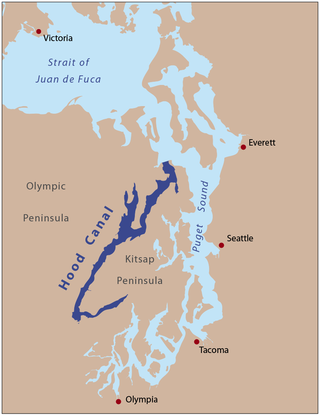
Hood Canal is a fjord-like body of water that lies west of Admiralty Inlet in Washington state that many people consider to be the western lobe and one of the four main basins of Puget Sound. It is one of the minor bodies of water that constitute the Salish Sea. Hood Canal is not a canal in the sense of an artificial waterway—it is a natural feature.

The Salmon Bay Bridge, also known as Bridge 6.3 on the BNSF railroad, formerly Bridge No. 4 on the Great Northern Railroad, is a Strauss Heel-trunnion single-leaf bascule bridge spanning Salmon Bay and connecting Magnolia/Interbay to Ballard in Seattle, Washington. The bridge is located just west of Commodore Park. It carries the main line of the BNSF Railway, the Scenic Subdivision, on its way north to Everett and south to King Street Station and Seattle's Industrial District.

The Fremont Bridge is a double-leaf bascule bridge that spans the Fremont Cut in Seattle, Washington. The bridge, which connects Fremont Avenue North and 4th Avenue North, connects the neighborhoods of Fremont and Queen Anne.

Washington Park is a public park in Seattle, Washington, United States, most of which is taken up by the Washington Park Arboretum, a joint project of the University of Washington, the Seattle Parks and Recreation, and the nonprofit Arboretum Foundation. Washington Park also includes a playfield and the Seattle Japanese Garden in its southwest corner. To the north is Union Bay; to the west are Montlake and Madison Valley; to the south is the Washington Park neighborhood; and to the east is the Broadmoor Golf Club.

The city of Seattle, Washington, is located on a narrow isthmus between Puget Sound on the west and Lake Washington on the east; water comprises approximately 41% of the total area of the city. It was founded on the harbor of Elliott Bay, home to the Port of Seattle—in 2002, the 9th busiest port in the United States by TEUs of container traffic and the 46th busiest in the world.

Smith Cove is a body of water, the northern part of Seattle, Washington's Elliott Bay, immediately south of the area that has been known since 1894 as Interbay. More precisely, it is the part of the bay that lies north of a line running southeasterly from the west end of Elliott Bay Marina in the northwest to the far northwest tip of Myrtle Edwards Park in the southeast.
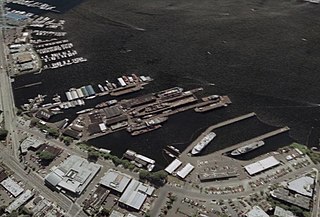
Lake Union Dry Dock Company is a full-service shipyard that specializes in vessel repair and conversions located in Seattle, Washington. Drydocking vessels up to 6,000 tonnes, , Lake Union Dry Dock Company repairs factory trawlers, fishing vessels, Coast Guard Cutters and buoy tenders, tugboats, research vessels, ferries, mega-yachts, barges, and houseboats.
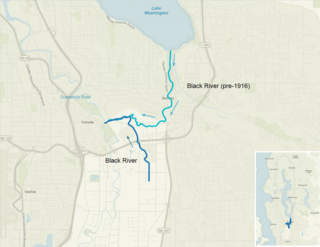
The Black River is a tributary of the Duwamish River in King County in the U.S. state of Washington. It drained Lake Washington until 1916, when the opening of the Lake Washington Ship Canal lowered the lake, causing part of the Black River to dry up. It still exists as a dammed stream about 2 miles (3.2 km) long.
The following outline is provided as an overview of and topical guide to infrastructure of the U.S. state of Washington.


