
The Karakoram is a mountain range in the Kashmir region spanning the border of Pakistan, China, and India, with the northwestern extremity of the range extending to Afghanistan and Tajikistan. Most of the Karakoram mountain range falls under the jurisdiction of Gilgit-Baltistan, which is controlled by Pakistan. Its highest peak, K2, is located in Gilgit-Baltistan, Pakistan. It begins in the Wakhan Corridor (Afghanistan) in the west, encompasses the majority of Gilgit-Baltistan, Pakistan and extends into Ladakh and Aksai Chin. It is part of the larger Trans-Himalayan mountain ranges.

The administrative units of Pakistan comprise four provinces, one federal territory, and two disputed territories: the provinces of Punjab, Sindh, Khyber Pakhtunkhwa, and Balochistan; the Islamabad Capital Territory; and the administrative territories of Azad Jammu and Kashmir and Gilgit–Baltistan. As part of the Kashmir conflict with neighbouring India, Pakistan has also claimed sovereignty over the Indian-controlled territories of Jammu and Kashmir and Ladakh since the First Kashmir War of 1947–1948. It also has a territorial dispute with India over Junagadh, but has never exercised administrative authority over either regions. All of Pakistan's provinces and territories are subdivided into divisions, which are further subdivided into districts, and then tehsils, which are again further subdivided into union councils.

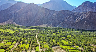
Gilgit is a city in Pakistani-administered Gilgit–Baltistan in the disputed Kashmir region. It is the capital of the Gilgit-Baltistan region. The city is located in a broad valley near the confluence of the Gilgit and the Hunza rivers. It is a major tourist destination in Pakistan, serving as a hub for trekking and mountaineering expeditions in the Karakoram mountain range.

The Karakoram Highway, also known as the KKH, National Highway 35, N-35, and the China–Pakistan Friendship Highway, is a 1,300 km (810 mi) national highway which extends from Hasan Abdal in the Punjab province of Pakistan to the Khunjerab Pass in Gilgit-Baltistan, where it crosses into China and becomes China National Highway 314. The highway connects the Pakistani provinces of Punjab and Khyber Pakhtunkhwa plus Gilgit-Baltistan with China's Xinjiang Uyghur Autonomous Region. The highway is a popular tourist attraction and is one of the highest paved roads in the world, passing through the Karakoram mountain range, at 36°51′00″N75°25′40″E at maximum elevation of 4,714 m (15,466 ft) near Khunjerab Pass. Due to its high elevation and the difficult conditions under which it was constructed, it is often referred to as the Eighth Wonder of the World. The highway is also a part of the Asian Highway AH4.

The Gilgit Agency was an agency within the British Indian Empire. It encompassed the subsidiary states of the princely state of Jammu and Kashmir situated along the northern border. The primary objective of establishing the Gilgit Agency was to bolster and fortify these regions, particularly in the context of concerns about Russian encroachment in the area. The subsidiary states encompassed Hunza, Nagar and other states in the present day districts of Gupis-Yasin, Ghizer, Darel, Tangir and Diamer. The agency headquarters was based in the town of Gilgit, within the Gilgit tehsil of Jammu and Kashmir.
Balawaristan, is a term coined by Nawaz Khan Naji, founder of the Pakistani political party Balawaristan National Front (BNF), for a proposed autonomous province or a sovereign state consisting of Gilgit-Baltistan, Chitral and Kohistan regions in Pakistan as well as Indian-controlled Ladakh. Although the name, first used in 1989, does not have any historical basis, it sounds similar to Baloristan, which has been documented in Chinese sources to describe Baltistan and Gilgit Valley from the 8th century CE.

The former administrative units of Pakistan are states, provinces and territories which mainly existed between 1947 and 1975 when the current provinces and territories were established. The former units have no administrative function today but some remain as historical and cultural legacies. In some cases, the current provinces and territories correspond to the former units – for example the province of Punjab includes almost all the territory of the former province of West Punjab.
Diamer District, also spelled Diamir District,) is a district in the Gilgit-Baltistan region administered by Pakistan. The headquarters of the district is the town of Chilas. The district is bounded on the north by the Tangir and the Gilgit districts, on the east by the Astore District, on the south by the Mansehra district of Pakistan's Khyber Pakhtunkhwa Province and the Neelum District of Pakistan controlled Kashmir, and on the west by the Upper Kohistan District of Khyber Pakhtunkhwa Province. The Karakoram Highway passes through Diamer District.

Gilgit-Baltistan is an administrative territory of Pakistan in the northern part of the country. It was given self-governing status on August 29, 2009. Gilgit-Baltistan comprises 14 districts within three divisions. The four districts of Skardu Kharmang Shigar and Ghanche are in the Baltistan Division, four districts of Gilgit Ghizer Hunza and Nagar districts which were carved out of Gilgit District are in the Gilgit Division and the third division is Diamir, comprising Chilas and Astore. The main political centres are the towns of Gilgit and Skardu.

Gilgit-Baltistan, formerly known as the Northern Areas, is a region administered by Pakistan as an administrative territory and consists of the northern portion of the larger Kashmir region, which has been the subject of a dispute between India and Pakistan since 1947 and between India and China since 1959. It borders Azad Kashmir to the south, the province of Khyber Pakhtunkhwa to the west, the Wakhan Corridor of Afghanistan to the north, the Xinjiang region of China to the east and northeast, and the Indian-administered union territories of Jammu and Kashmir and Ladakh to the southeast.
There are or have been a number of separatist movements in Pakistan based on ethnic and regional nationalism, that have agitated for independence, and sometimes fighting the Pakistan state at various times during its history. As in many other countries, tension arises from the perception of minority/less powerful ethnic groups that other ethnicities dominate the politics and economics of the country to the detriment of those with less power and money. The government of Pakistan has attempted to subdue these separatist movements.
The N–15 or National Highway 15 is a 240-kilometre-long national highway in Pakistan. It connects the city of Mansehra in Pakistan's Khyber Pakhtunkhwa province to the city of Chilas in the administrative territory of Gilgit–Baltistan. It is often used as a bypass for the Karakoram Highway (N–35) and is popular amongst tourists who visit Naran and its surrounding region.
Gilgit-Baltistan is an administrative territory of Pakistan that borders the province of Khyber Pakhtunkhwa to the west, Azad Kashmir to the southwest, Wakhan Corridor of Afghanistan to the northwest, the Xinjiang Uyghur Autonomous Region of China to the north, and the Indian-administered region of Jammu and Kashmir to the south and south-east.
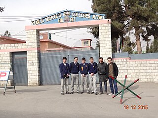
Since its independence in 1947, governments have not spent much on quality education in this region. While the literacy rates of the areas in Gilgit is higher than most of the citites in Pakistan, yet no professional universities were constructed in the region. In 2002, under the reign of Pervez Musharraf, a general university of the name of Karakoram International University was constructed. Various primary schools were constructed by NGO's from around the world including the Aga Khan Development Network.

There are many types of gemstones of Pakistan. They can be found among the nation's three mountain ranges - the Hindu Kush, the Himalayas, and the Karakoram - in the provinces of Khyber Pakhtunkhwa, Gilgit-Baltistan, Balochistan, and the Federally Administered Tribal Areas. The gemstone industry in Pakistan has the city of Peshawar as its hub, and there are many companies working in it.
The Government of Gilgit-Baltistan is the government of the administrative territory of Gilgit-Baltistan, Pakistan. Its powers and structure are set out in the 2009 Gilgit-Baltistan Empowerment and Self-Governance Order, in which 14 districts come under its authority and jurisdiction. The government includes the cabinet, selected from members the Gilgit–Baltistan Assembly, and the non-political civil staff within each department. The province is governed by a unicameral legislature with the head of government known as the Chief Minister. The Chief Minister, invariably the leader of a political party represented in the Assembly, selects members of the Cabinet. The Chief Minister and Cabinet are thus responsible the functioning of government and are entitled to remain in office so long as it maintains the confidence of the elected Assembly. The head of state of the province is known as the Governor. The terms Government of Gilgit–Baltistan or Gilgit–Baltistan Government are often used in official documents. The seat of government is in Gilgit, thus serving as the capital of the territory.

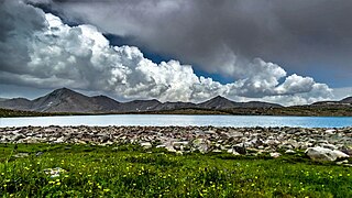
Tourism in Gilgit-Baltistan, an administered territory of Pakistan, focuses on its access to various mountain ranges and alpine terrain. Various tourist destinations attract millions of travelers from within Pakistan. On the other hand, tourists from other countries also routinely visit GB. An estimated 1.72 million tourists visited the region in 2017 according to the Pakistan Tourism Development Corporation (PTDC). Travelers had contributed Rs.300 million to the local economy in 2017. The authorities were expecting 2.5 million tourists in 2018 which would have meant an additional Rs.450 million to the economy.
Nomal is a small valley located at a distance of 25 km north of Gilgit city in the Gilgit District, in northern Pakistan. The valley is also connected with Nalter Bala and Nalter Pain through a metaled road.

Elections were held on 12 November 2009 in the province of Gilgit-Baltistan for the first time to elect the first Assembly of Gilgit-Baltistan.

The 2015 Gilgit-Baltistan Assembly elections were held on 8 June 2015. Elections were held in 24 constituencies, each electing one member to the 2nd Gilgit-Baltistan Legislative Assembly. 269 candidates contested these elections, either representing one of the political parties of Gilgit-Baltistan or being an independent candidate.