Azad Jammu and Kashmir , part of the former British princely state of Jammu and Kashmir, is an autonomous state of Pakistan. [1] The history of the region dates back to thousands of years. A survey team in 2014 recorded around 100 archaeological sites in the region dating back to Mughal, Sikh, and Dogra rule. [2]
Following is an incomplete list of cultural heritage sites in Azad Kashmir, Pakistan.
ID | Name | Type | Location | District | Coordinates | Image |
---|---|---|---|---|---|---|
AJK-1 | Bagh Fort | Fort | In the town of Bagh [3] [4] | Bagh District | More images | |
AJK-2 | Baghsar Fort | Fort | Near the town of Baghsar [3] [5] | Bhimber District | 33°02′22″N74°12′23″E / 33.0395091°N 74.206295°E | More images |
AJK-3 | Mughal Mosque | Mosque | In the town on Bhimber [3] | Bhimber | More images | |
AJK-4 | Haathi gate (Mughal Elephant gate) | Historical site | Near purani kacheri in the town on Bhimber | Bhimber | Upload Photo | |
AJK-5 | Sarai Saadabad | Historical site | Samahni [3] | Bhimber | More images | |
AJK-6 | Darbar Baba Shadi Shaheed | Shrine | In Jandi Chontra [3] [5] | Bhimber | 33°03′03″N74°06′55″E / 33.0508767°N 74.1151965°E | More images |
AJK-7 | Ali Baig Gurdwara | Gurdwara | In the village of Ali Baig near Khalsa Middle School [2] | Bhimber | 33°00′39″N73°52′10″E / 33.01072°N 73.86955°E | More images |
AJK-8 | Darbar Haji Pir | Shrine | Located near Aliabad [6] | Haveli District | Upload Photo | |
AJK-9 | Throchi Fort | Fort | Located in Gulpur at end of Gulpur-Throchi Road on top of the hill [3] | Kotli District | 33°25′43″N73°52′36″E / 33.428539°N 73.876602°E | More images |
AJK-10 | Bhrund Fort | Fort | Located in Sehnsa [3] | Kotli | Upload Photo | |
AJK-11 | Darbar Mai Toti Sahiba | Shrine | In Pandli Sharif, 4 kilometres (2.5 mi) from Khuiratta [3] | Kotli | More images | |
AJK-12 | Fountains and gardens at Khuiratta | Historical site | In the town of Khuiratta38 kilometres (24 mi) from Kotli city [7] | Kotli | Upload Photo | |
AJK-13 | Ramkot Fort | Fort | Across the Mangla lake from Sukhian (travel via boat) [8] [9] | Mirpur District | 33°13′25″N73°38′30″E / 33.2235°N 73.6418°E | More images |
AJK-14 | Shrines of Khari Shareef | Shrine | located 8 kilometres (5.0 mi) south of Mirpur city on Darbaar Road [8] [ dead link ] | Mirpur | 33°05′03″N73°45′38″E / 33.0842°N 73.7605°E | More images |
AJK-15 | Mangla Fort | Fort | Next to Mangla Dam (possibly off-limits) [3] [10] | Mirpur | 33°07′53″N73°38′26″E / 33.1315138°N 73.6405849°E | More images |
AJK-16 | Burjun Fort | Fort | In Burjun, [3] | Mirpur | More images | |
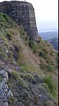
AJK-17 | Pir Chinasi (Pir Shah Hussain Bukhari's shrine) | Shrine | At the end of Pir Chinasi Road [11] | Muzaffarabad District | 34°23′20″N73°32′59″E / 34.3888°N 73.5498°E | More images |
AJK-18 | Red Fort (Muzaffarabad Fort, Rutta Qila, Chak Fort) | Fort | In Muzaffarabad city, near Challah Bridge on Neelam Road [11] [12] | Muzaffarabad | 34°22′56″N73°27′53″E / 34.3823°N 73.4647°E | More images |
AJK-19 | Black Fort (Gojra Fort) | Fort | Police Line Road, in Muzaffarabad city. Currently used as a cantonment by Pakistan Army. Off limits to public. [11] [13] [14] | Muzaffarabad | 34°21′35″N73°28′00″E / 34.3596°N 73.4668°E | Upload Photo |
AJK-20 | Kohala Bridge | Historical site | On Kohala-Muzaffarabad Road | Muzaffarabad | 34°05′46″N73°29′55″E / 34.096083°N 73.498666°E | More images |
AJK-21 | Quaid-e-Azam tourist lodge, Barsala | Historical site | On Kohala-Muzaffarabad Road 3 kilometres (1.9 mi) from Kohala Bridge on the way to Muzaffarabad [11] | Muzaffarabad | 34°07′48″N73°29′49″E / 34.129958°N 73.497056°E | More images |
AJK-22 | Sain Saheli Sarkar Darbar | Shrine | in District Headquarter office complex, Muzaffarabad [3] | Muzaffarabad | 34°21′29″N73°28′26″E / 34.35792°N 73.47396°E | More images |
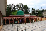
AJK-23 | Sharda Peeth | Ruins, Archaeological site | Located in the town of Sharda near the Main Bazaar [3] | Neelum Valley | 34°47′32″N74°11′24″E / 34.7921°N 74.1901°E | More images |
AJK-25 | Baral Fort | Fort | 12 miles (19 km) south of Pallandri in the town of Baral [3] [15] | Sudhanoti District | 33°38′14″N73°42′14″E / 33.6372079°N 73.7038583°E | More images |
AJK-26 | Rani Bowli (Pallandri bowli) | Historical site | On outskirts of Pallandri town [3] [4] | Sudhanoti | More images | |
AJK-27 | Bharand Fort | Fort | [2] [10] | More images | ||
AJK-28 | Aion Fort | Fort | [16] [2] | Upload Photo | ||
AJK-29 | Ranbir Singh Baradari | Historical site | Domel Bridge, Muzaffarabad | Muzaffarabad | More images | |
AJK-30 | Karjai Fort (khui ratta) [3] | Historical site | On Karjai mountain khuiratta kotli [10] | Kotli | Upload Photo | |
AJK-31 | Nerian Sharif | Historical site and shrine | Sudhanoti | 73°46′20″N33°45′06″E / 73.7722°N 33.7517°E | Upload Photo | |
AJK-32 | Sri Dheri Gurdwara | Historical ruins of a Gurdwara | 3 km from downtown Rawalakot | Poonch | Upload Photo |
Azad Jammu and Kashmir, abbreviated as AJK and colloquially referred to as simply Azad Kashmir, is a region administered by Pakistan as a nominally self-governing entity and constituting the western portion of the larger Kashmir region, which has been the subject of a dispute between India and Pakistan since 1947. Azad Kashmir also shares borders with the Pakistani provinces of Punjab and Khyber Pakhtunkhwa to the south and west, respectively. On its eastern side, Azad Kashmir is separated from the Indian union territory of Jammu and Kashmir by the Line of Control (LoC), which serves as the de facto border between the Indian- and Pakistani-controlled parts of Kashmir. Geographically, it covers a total area of 13,297 km2 (5,134 sq mi) and has a total population of 4,045,366 as per the 2017 national census.
Bagh District is a district of Pakistan-administered Azad Kashmir in the disputed Kashmir region. It is one of the ten districts of Azad Jammu and Kashmir. Previously part of Poonch District, it was established as a separate district in 1988.
Pallandri, also spelled Palandri, originally Pulandari, is a Tehsil which serves as administrative capital of Sudhanoti district of Azad Kashmir. It is located at latitude 33° 42′ 54″ N, longitude 73° 41′ 9″ E, 90 km (56 mi) from Islamabad, the capital of Pakistan. It is connected with Rawalpindi and Islamabad through Azad Pattan road. The main tribe of Pallandri is the Sudhan tribe. Here in Palindri First Government of Sidhnuti Azad Kashmir on October 4,1947 was established
Red Fort, also known as Muzaffarabad Fort, is a 17th-century fortification located in Muzaffarabad, Azad Jammu and Kashmir, Pakistan. It was built by the Chak dynasty of Kashmir. The fort is locally referred to as the 'Rutta Qila' or just 'qila'.
Neelum is a district of Pakistan-administered Azad Kashmir in the disputed Kashmir region. It is the northernmost of 10 districts located within the Pakistani-administered territory of Azad Kashmir. Taking up the larger part of the Neelum Valley, the district has a population of around 191,000 people. It was among the worst-hit areas of Pakistan during the 2005 Kashmir earthquake.
The president of Azad Kashmir, Officially the president of the State of Azad Jammu and Kashmir is the constitutional and ceremonial head of state of Azad Kashmir.
The prime minister of Azad Kashmir is the chief executive of Azad Jammu and Kashmir region of Pakistan. The title of Prime Minister symbolizes the nominal independence of Azad Kashmir. The prime minister heads the Council of Ministers, who are members of the Azad Kashmir Legislative Assembly, the PM too is elected by the AJK Legislative Assembly which is directly elected by the people.
The AJK Jaguars was a Pakistani men's professional Twenty20 cricket team that competed in the Haier T20 League and based in Mirpur, Azad Jammu and Kashmir, Pakistan. The Jaguars played at the Mirpur Cricket Stadium and was owned by the AJK Regional Cricket Association.
Azad Jammu Kashmir Medical College or (AJKMC) is a public medical institute located in Muzaffarabad, Azad Jammu & Kashmir, Pakistan. AJKMC is home to 500 students in the MBBS program, with clinical rotations occurring at Combined Military Hospital Muzaffarabad and Abbas Institute of Medical Sciences. AJKMC was established and recognized by the Pakistan Medical and Dental Council in 2011.
The Azad Kashmir Police or Azad Jammu and Kashmir Police (AJKP) is responsible for law enforcement in the Azad Kashmir region administered by Pakistan. It is headed by Inspector-General of Police, Amir Ahmed Sheikh (PSP), and headquartered in the Central Police Office (CPO) Muzaffarabad, Azad Kashmir.
Sahibzada Muhammad Ishaq Zaffar also known as Ishaq Zaffar (1945–2006) was a Pakistani politician in Azad Kashmir administrative territory. He filled various positions in the Azad Kashmir government from the 1970s until dying in office in 2006, beginning as a member of the Pakistan People's Party, serving as member of the Azad Kashmir Legislative Assembly, Speaker of the Assembly, Acting President of Azad Kashmir, and senior minister, and was opposition leader in the constituent assembly at the time of his death. He contested elections for constituent assembly of Azad Kashmir for five times and always won assembly seat.
The Government of Azad Kashmir is the state government which administers one of the territories of Pakistani-administered Kashmir territories of Azad Kashmir. The Azad Kashmir government consists of a president as head of state and a prime minister as chief executive, with the support of a council of ministers. The state assembly is the Azad Kashmir Legislative Assembly.
"Watan Hamārā Āzād Kashmīr", officially known as the Anthem of Azad Jammu and Kashmir is the national anthem of the state of Azad Kashmir, administered by Pakistan. It is based on a poem of the same name written in the mid-1960s by Hafeez Jalandhari. It was inspired during the Indo-Pakistani War of 1965.
Kashmiris in Azad Kashmir are the ethnic Kashmiri people who reside in Azad Kashmir, a territory which constitutes part of Pakistani-administered Kashmir since the end of the First Kashmir War. Their demographic includes up to 40,000 registered Kashmiri refugees who have fled the Kashmir Valley, located in Indian-administered Kashmir, to Pakistan since the late 1980s due to conflict in the region. As of 2010, only around 60 percent of Kashmiri refugees had acquired Pakistani citizenship.
On 3 November 2021, a 40-seater bus heading to Rawalpindi carrying more than 30 passengers fell into a ditch in Pallandri, Sudhanoti District, Azad Jammu and Kashmir killed at least 23 people, including women and children and seven others were injured.
The Interim Constitution of Azad Jammu and Kashmir provides for an apparently transitory autonomous parliamentary framework of self-governance and power sharing for the region of Azad Jammu and Kashmir, defined by the act as the "territories of the State of Jammu and Kashmir which have been liberated by the people of that State and for the time being under the administration of Government and such other territories as may hereafter come under its administration", however it does not pertain to areas such as Gilgit, Hunza and Baltistan. The act succeeded and re-enacted the Azad Jammu and Kashmir Government Act, 1970 with modifications. It was promulgated under the Prime Minister of Pakistan Zulfiqar Ali Bhutto. The constitution has been amended 14 times. It is based on the 1973 Constitution of Pakistan.
The Azad Jammu & Kashmir Election Commission is an independent, autonomous, permanent and constitutionally established body responsible for organizing and conducting elections to the Azad Jammu and Kashmir Legislative Assembly, Kashmir council, local governments, and the office of President of Azad Kashmir, as well as the delimitation of constituencies and preparation of electoral rolls. In accordance with the principles set down in the Interim Constitution of AJK, the commission makes the necessary measures to guarantee that the election is conducted honestly, justly, fairly, and in compliance with the law, and that corrupt practices are prevented.
The Azad Jammu and Kashmir Council or AJK Council is a supreme legislative and executive body of the Government of Azad Jammu and Kashmir which works under the federal Government of Pakistan. This governing body has more constitutional, executive, financial, legal, and administrative powers than the Legislative Assembly of Azad Jammu and Kashmir.
Mangla Fort is a historical fort located in Mangla, Azad Kashmir. It is currently under the administration of the Pakistan Army and is not publicly accessible.
Throchi Fort is a historical fort in Throchi village of Kotli district in Azad Jammu and Kashmir. The fort is situated on a hilltop overlooking the village and surrounding areas.