Of the some 400 sites and monuments protected under the Antiquities Act 1975, the province contains seven sites in Category 1, eight in Category II and fourteen in Category III.[3]
National monuments, UNESCO inscribed and tentative sites
Federal Government
The following sites were previously protected under the Federal Government.
Balochistan is a province of Pakistan. Located in the southwestern region of the country, Balochistan is the largest province of Pakistan by land area but is the least populated one. It is bordered by the Pakistani provinces of Khyber Pakhtunkhwa to the north-east, Punjab to the east and Sindh to the south-east; shares international borders with Iran to the west and Afghanistan to the north; and is bound by the Arabian Sea to the south. Balochistan is an extensive plateau of rough terrain divided into basins by ranges of sufficient heights and ruggedness. It has the world's largest deep sea port, the Port of Gwadar lying in the Arabian Sea.
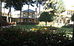
Quetta is the capital and largest city of the Pakistani province of Balochistan. It is the tenth largest city in Pakistan, with a population of over 1.1 million. It is situated in the south-west of the country, lying in a valley surrounded by mountains on all sides. Quetta is at an average elevation of 1,680 metres above sea level, making it Pakistan's only high-altitude major city. The city is known as the "Fruit Garden of Pakistan" due to the numerous fruit orchards in and around it and the large variety of fresh and dried fruits produced there.
Quetta is a district in the northwestern part of the Balochistan province of Pakistan, on the border with Kandahar province, Afghanistan.
Zhob District is a district in the northwestern part of Balochistan province of Pakistan. The population of Zhob District was estimated at 310,544 in 2017. Water from Zhob River is used for irrigation in the district.
Barkhan is a district in the province of Balochistan in Pakistan. It shares its borders with the province of Punjab to the east and the Balochistan districts of Dera Bugti to the south, Kohlu to the west, Loralai to the northwest and Musakhel to the north. The town of Barkhan serves as the district's headquarters. It was granted the status of a separate district on 31 December 1991, prior to which it was a tehsil within Loralai District.
Kachhi or Kacchi, previously known until 2008 as Bolan District, is a district located in the central part of the Balochistan province in Pakistan. The Bolan area remained under one district Kacchi until 31 December 1991. The Deputy Commissioner's office started functioning on 17 May 1992, and Bolan became one of the four districts of Naseerabad Division, until the abolition of Divisions in 2000.
Khuzdar is a district in the Balochistan province of Pakistan. The city of Khuzdar serves as the district's headquarters.
Musakhail (Urdu: ضلع موسیخیل) is a district in the northeast of the Balochistan province of Pakistan. It became a separate district in 1992, prior to which it was a tehsil within Loralai District. Musakhail District is now part of Loralai Division, which was created after splitting Zhob Division.
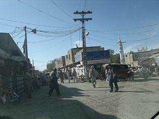
Zhob, formerly known as Appozai, is a city and district headquarters of the Zhob District in the Balochistan province of Pakistan. Zhob is located on the banks of the Zhob river. It lies 337 kilometres away from Quetta, the capital of Balochistan.
The Chief Commissioner's Province of British Baluchistan was a province of British India established in 1876. Upon the creation of Pakistan it acceded to the newly formed state. It was part of the Baluchistan Agency. It was dissolved to form a united province of West Pakistan in 1955 upon the creation of One Unit Scheme.
The four provinces, capital territory, and two autonomous territories of Pakistan are subdivided into 39 administrative "divisions", which are further subdivided into districts, tehsils, and finally union councils. These divisions were abolished in 2000, but restored in 2008.
Zhob Division is an administrative division of Balochistan Province, Pakistan. It was created in 1988 bifurcated from Quetta division. It remained abolished between 2000 and 2008 during the military rule of Pervez Musharraf, but later restored when his rule ended. CNIC Code of Zhob Division is 56.
Ihsan H. Nadiem is a Pakistani archaeologist, museologist, author and poet.
Kila Saifullah District, Qilla Saifullah, or Saifullah Killa is a district in northwestern Balochistan province, Pakistan. It was established as a district in 1988, comprising two former administrative units of Zhob District: the Upper Zhob sub-division and the sub-tehsil of Badinai, previously named Kashatoo and part of the sub-district of Kakar Khurasan.
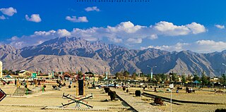
Tourism in Balochistan is a developing industry, and is overseen by the Tourism Directorate under the Government of Balochistan. Balochistan is known for its long coastal belt which extends from Karachi through Sonmiani, Ormara, Kalmat, Pasni, Gwadar, Jiwani and all the way up to Iran. It is also popular for its hill tops and rugged mountainous terrain.
Balochistan Levies is a paramilitary gendarmerie in the Pakistani province of Balochistan. It operates as one of two primary law enforcement agencies tasked with maintaining law and order in the province, along with Balochistan Police. The levies force has jurisdiction in most districts of Balochistan.
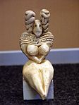
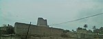
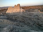
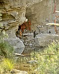
Periano Ghundai meaning "The Hill of Fairies" was an archaeological mound located in the Zhob district in Balochistan, Pakistan. The site is located 3 kilometres (1.9 mi) west of the town of Zhob. It was excavated in 1924 by Sir Aurel Stein and showed great resemblance to the Harappan culture.
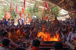
Hinduism is a minority religion in Balochistan followed by 0.4% of the population of the province. It is the largest minority religion in Balochistan. The Balochistan is home to the shrine of Shri Hinglaj Mata temple, which is one of the most sacred Hindu temples. The annual Hinglaj Yatra to the temple is the largest Hindu pilgrimage in Pakistan.
1 2 3 4 5 6 7 8 Important/Historical Places, 1998 District Census Report of Lasbella. Population Census Organisation, Government of Pakistan 1999 pg 16
1 2 3 4 5 Important/Historical Places, 1998 District Census Report of Lasbella. Population Census Organisation, Government of Pakistan 1999 pg 17
1 2 3 4 5 6 Important/Historical Places, Quetta City in 1998 District Census Report of Quetta, Population Census Organisation, Government of Pakistan 2001 pg 11
1 2 Important/Historical Places, Quetta City in 1998 District Census Report of Quetta, Population Census Organisation, Government of Pakistan 2001 pg 12
1 2 3 4 5 Important/Historical Places, 1998 District Census Report of Zhob, Population Census Organisation, Government of Pakistan 2000 pg 12
↑ Important/Historical Places, 1998 District Census Report of Zhob, Population Census Organisation, Government of Pakistan 2000 pg 13
This page is based on this Wikipedia article Text is available under the CC BY-SA 4.0 license; additional terms may apply. Images, videos and audio are available under their respective licenses.