List of forts in Pakistan

Last updated

The following is a partial list of forts and castles in Pakistan:

Contents

NameLocationProvince/RegionDate of CompletionOwnership / Built byImageNotes
Sialkot Fort Sialkot District Punjab 2nd Century Raja Sálbán
Al-Ror Sukkur District Sindh
Throchi Fort Kotli District Azad Kashmir 1460
Shagai Fort Khyber District Khyber Pakhtunkhwa 1927 Shagai Fort.jpg
Harkishan Garh Fort Haripur District Khyber Pakhtunkhwa 1822–23
Baghsar Fort [1] Samahni Valley, Bhimber Azad Kashmir Mughal Empire [2] Bhagsar3.jpg Currently closed to visitors, due to it being right beside Line of Control between Pakistan and India.
Ramkot Fort Mirpur Azad Kashmir 16–17th Century Gakhars Ramkot Fort Dadyal.jpg
Karjai Fort Khuiratta, Kotli District Azad Kashmir [3]
Red Fort, Muzaffarabad Muzaffarabad Azad Kashmir 1646 Sultan Muzaffar Khan Red Fort Muzaffarabad.jpg Locally, it is known as the "Rutta Qila" or just "qila".
Zhob Fort [4] Zhob Balochistan 1867 British Raj Also known as Sandeman Fort.
Kalat Fort [5] Kalat Balochistan Kalatuk Kalat.jpg The town of Kalat is said to have been founded by and named Qalat-e Sewa (Sewa's Fort), after Sewa, a legendary hero of the Baloch people.
Punno Fort [6] Turbat Balochistan Also known as "Meeri Kalaat". Location 26°2′2″N63°00′46″E / 26.03389°N 63.01278°E / 26.03389; 63.01278
Fort Munro D.G.Khan Punjab Pakistan 1800 John Munro, 9th of Teaninich Damis Lake, Fort Munro.jpg Locally, it is known as the "South Punjab Murree".
Sibi Fort [7] Sibi Balochistan
Baltit Fort Hunza Valley Gilgit Baltistan Baltit Fort East Elevation.JPG Since 2004, it has been on the UNESCO World Heritage Tentative list.
Skardu Fort Skardu Gilgit Baltistan SkarduFortEntrance1167.JPG
Altit Fort Altit, Hunza Valley Gilgit Baltistan 11th Century Altit Fort Hunza.jpg
Shigar Fort Shigar Gilgit Baltistan 17th CenturyAmacha Dynasty Shigar fort.JPG The Shigar Fort means The Fort on Rock.
Khaplu Fort Khaplu, Ghanche District Gilgit Baltistan Khaplu Fort - Daytime.jpg It is locally known as Yabgo Khar, meaning "The fort on the roof".
Kalam Darchi Fort Misgar Valley, Gojal(Upper Hunza) Gilgit Baltistan 1933 British Raj 
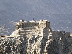
This fort was named after a naked saint and was built by British soldiers during 1932–33 to check the invasion and inflow of people from China and USSR through Wahkan corridor. It remained the abode of Gilgit Scouts. [8]
Bala Hisar Fort Peshawar Khyber Pakhtunkhwa Balahisar-peshawar.jpg also known as Qila Balahisar
Chitral Fort [9] Chitral Khyber Pakhtunkhwa Shahi Fort Chitral KPK Pakistan.JPG 35°51′19″N71°47′30″E / 35.85528°N 71.79167°E / 35.85528; 71.79167
Mastuj Fort [10] Mastuj Khyber Pakhtunkhwa Mastuj Fort.jpg
Drosh Fort Chitral Khyber Pakhtunkhwa
Chakdarra Fort [11] Lower Dir District Khyber Pakhtunkhwa 1586 Mughal Empire The Mughals built a fort here in 1586, occupied in 1895 by the British, who built the present fort in 1896. 34°38′50″N72°01′42″E / 34.64722°N 72.02833°E / 34.64722; 72.02833
Malakand Fort Malakand District Khyber Pakhtunkhwa
Handyside Fort Kohat Khyber Pakhtunkhwa British Raj Handyside Fort 1.jpg
Attock Fort Attock Khurd, Attock Punjab 1583 Mughal Emperor Akbar Attock Fort - Optographer.jpg 
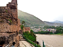
Attock Fort was built at Attock Khurd during the reign of Akbar the Great from 1581 to 1583 under the supervision of Khawaja Shamsuddin Khawafi to protect the passage of the River Indus.
Rohtas Fort Jhelum Punjab 16th Century Sher Shah Suri Rohtas Fort Magnificent Kabuli Gate.jpg
Derawar Fort Bahawalpur Punjab Rajput Night View of Derawar Fort.jpg
Lahore Fort Lahore Punjab 1605 Mughal Emperor Akbar Lahore Fort view from Baradari.jpg
Malot Fort Chakwal Punjab 1527 Mughal Emperor Babur Malot temple 12.jpg
Darbar Mahal [12] Bahawalpur Punjab
Pharwala Castle Rawalpindi Punjab 15th Century Gakhars Gate of Pharwala Fort toward the Swaan stream.JPG
Sheikhupura Fort [13] Sheikhupura Punjab 1607 Mughal Emperor Jahangir Qila sheikhupura01.jpg
Multan Fort Multan Punjab 800 - 1000 BCThe fort was destroyed by British forces.
Mankera Fort Mankera, Bhakkar District Punjab Ruins of Mankera Fort.jpg
Meer Garh Fort Meer Garh Punjab 29°10′26″N72°37′15″E / 29.17389°N 72.62083°E / 29.17389; 72.62083
Marot Fort Marot Punjab [14] A ruined fortress town. 29°10′37″N72°26′00″E / 29.17694°N 72.43333°E / 29.17694; 72.43333
Fort Abbas Fort Abbas Tehsil, Bahawalnagar District Punjab
Bavaani Fort Sahiwal Punjab
Shujabad Fort Shujabad Punjab
Nandana Fort Jhelum Punjab Fort Nandana ruins.JPG 
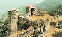
Al-Beruni (973-1053 AD), the celebrated traveler, historian, philosopher, mathematician, astronomer and scientist, came to the subcontinent in the period of Mehmood of Ghazni during the 11th century. It was at Nandana, that he measured the circumference of the earth. [15]
Satghara Okara District Punjab Satghara Temple.jpg It is also believed to be the location of the tomb of Baloch king, Mir Chakar Rind (1468–1565).
Kot Diji Fort Kot Diji, Khairpur District Sindh 1795Mir Sohrab Khan Talpur Detail of Kot Diji Fort.jpg
Ranikot Fort Jamshoro District Sindh 17th Century Rani Kot09a.jpg 
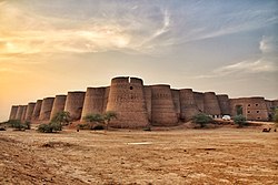
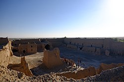
Ranikot Fort is also known as The Great Wall of Sindh and is believed to be the world's largest fort with a circumference of approximately 26 kilometres (16 mi). [16] Since 1993, it has been on the tentative list of UNESCO World Heritage Sites. [17]
Naukot Fort Tharparkar Sindh Naukot Fort 2011 MIT 0504.jpg
Bukkur Fort Sukkur Sindh Vintage picture of Bhakkar Fort.jpg 27°41′46″N68°53′3″E / 27.69611°N 68.88417°E / 27.69611; 68.88417
Sehwan Fort Sehwan Sharif Sindh
Qasim fort Karachi Sindh 18th Century CE Talpur dynasty QASIM Fort.JPG
Pacco Qillo Hyderabad Sindh 1768 Mian Ghulam Shah Kalhoro Pakka Qila view3.JPG
Umerkot Fort Umerkot Sindh Rajput Umarkot Fort view3.JPG
Kadiro Fort Sindh
Rawat Fort Islamabad Islamabad Capital Territory Gakhars Rawat Fort Main gate.JPG
Jamrud Fort Jamrud, Khyber Agency Khyber Pakhtunkhwa 1836 Hari Singh Nalwa Jamrud Fort close view.JPG
Miranshah Fort Miranshah, North Waziristan Khyber Pakhtunkhwa
Wana Fort Wana, Pakistan, South Waziristan Khyber Pakhtunkhwa
Ali Masjid Fort Khyber Agency Khyber Pakhtunkhwa 1837 Dost Mohammad Khan Ali Masjid fort - franek2.jpg
Islamgarh Fort Khanpur, Rahim Yar Khan District Punjab 1665Raja Rawal Siri Bheem Singh Islam Garh Fort Cholistan.jpg [18]
Moj Garh Fort Bahawalnagar, Bahawalnagar District Punjab [19]
Bijnot Fort Cholistan Desert in Bahawalpur District Punjab Bijnot fort.jpg
Deen Garh Fort [20]
Khair Garh Fort Khanpur, Rahim Yar Khan District Punjab
Nawan Kot Fort
Jaam Garh Fort
Khan Garh Fort Khanpur, Rahim Yar Khan District Punjab

See also

Related Research Articles

<span class="mw-page-title-main">Khyber Pakhtunkhwa</span> Province of Pakistan

Khyber Pakhtunkhwa is a province of Pakistan. Located in the northwestern region of the country, Khyber Pakhtunkhwa is the fourth largest province of Pakistan by land area and the third-largest province by population. It is bordered by the Pakistani provinces of Balochistan to the south, Punjab to the south-east, the territory of Gilgit-Baltistan to the north and north-east, Islamabad Capital Territory to the east and Azad Kashmir to the north-east. It shares an international border with Afghanistan to the west. Khyber Pakhtunkhwa has a varied landscape ranging from rugged mountain ranges, valleys, plains surrounded by hills, undulating submontane areas and dense agricultural farms.

<span class="mw-page-title-main">Demographics of Pakistan</span>

Pakistan had a population of 241,492,197 or 241.49 Million according to the final results of the 2023 Census. This figure includes Pakistan's four provinces e.g. Punjab, Sindh, KPK, Balochistan and Islamabad Capital Territory. AJK and Gilgit-Baltistan's census data is yet to be approved by CCI Council of Pakistan. Pakistan is the world's fifth most populous country.

<span class="mw-page-title-main">Punjab, Pakistan</span> Province of Pakistan

Punjab, known historically as Panchanada and Pentapotamia, is a province of Pakistan. Located in central-eastern region of the country, Punjab is the second-largest province of Pakistan by land area and the largest by population. Lahore is the capital and the largest city of the province. Other major cities include Faisalabad, Rawalpindi, Gujranwala and Multan.

<span class="mw-page-title-main">Peshawar</span> Capital city of Khyber Pakhtunkhwa, Pakistan

Peshawar is the sixth most populous city of Pakistan, with a population of over 1.97 million in the 2017 census. It is situated in the north-west of the country, lying in the Valley of Peshawar. It is the capital of the province of Khyber Pakhtunkhwa, where it is the largest city. Peshawar is primarily populated by Pashtuns, who comprise the second-largest ethnic group in the country. Situated in the Valley of Peshawar, a broad area situated east of the historic Khyber Pass, Peshawar's recorded history dates back to at least 539 BCE, making it one of the oldest cities in South Asia. Peshawar also remained the capital of Gandhara civilization and is among the oldest continuously inhabited cities in the country.

<span class="mw-page-title-main">Languages of Pakistan</span> Overview of languages spoken in Pakistan

Pakistan is a multilingual country with over 70 languages spoken as first languages. The majority of Pakistan's languages belong to the Indo-Iranian group of the Indo-European language family.

<span class="mw-page-title-main">Galyat</span> Region in Khyber Pakhtunkhwa and Punjab, Pakistan

Galyat region, or hill tract, is a narrow strip or area roughly 50–80 km north-east of Islamabad, Pakistan, extending on both sides of the Khyber Pakhtunkhwa-Punjab border, between Abbottabad and Murree. The word itself is derived from the plural of the Urdu word gali, which means an alley between two mountains on both sides of which there are valleys and it is not the highest point in the range. Many of the towns in the area have the word gali as part of their names, and are popular tourist resorts. Being on linguistic and geographical continuum this area has challenged social scientists in terms of anomalous classification.

<span class="mw-page-title-main">International Mother Language Day</span> Worldwide annual observance to promote awareness of linguistic and cultural diversity

International Mother Language Day is a worldwide annual observance held on 21 February to promote awareness of linguistic and cultural diversity and to promote multilingualism. First announced by UNESCO on 17 November 1999, it was formally recognized by the United Nations General Assembly with the adoption of UN resolution 56/262 in 2002. Mother Language Day is part of a broader initiative "to promote the preservation and protection of all languages used by peoples of the world" as adopted by the UN General Assembly on 16 May 2007 in UN resolution 61/266, which also established 2008 as the International Year of Languages. The idea to celebrate International Mother Language Day was the initiative of Bangladesh. In Bangladesh, 21 February (1952) is the anniversary of the day when the Bengalis i.e. Pakistani Bengali Muslims of the Pakistani province of East Bengal fought for recognition of their Bengali language. It is also observed by the Indian Bengalis of the Indian states of West Bengal, Assam, Jharkhand and Tripura.

<span class="mw-page-title-main">Jamshoro</span> City in Sindh, Pakistan

Jamshoro is a city and the capital of Jamshoro District, located in Sindh, Pakistan. It is on the right bank of the Indus River, approximately 18 km (11 mi) northwest of Hyderabad and 150 km (93 mi) northeast from the provincial capital of Sindh, Karachi.

<span class="mw-page-title-main">Mardan</span> City in Khyber Pakhtunkhwa, Pakistan

Mardān is a city in the Mardan District of Khyber Pakhtunkhwa Province, Pakistan. Located in the Valley of Peshawar, Mardan is the second-largest city of Khyber Pakhtunkhwa. It is a fast-growing city that experienced a population boom in the latter half of the twentieth century.

<span class="mw-page-title-main">Kumbhalgarh</span> Fort at Rajsamand District of Rajasthan

Kumbhalgarh, also known as the Great Wall of India, is a Mewar fortress on the westerly range of Aravalli Hills about 48 km from Rajsamand city in the Rajsamand district of the Rajasthan state in western India. It is located about 84 km from Udaipur. It is a World Heritage Site included in Hill Forts of Rajasthan. It was built during the 15th century by Rana Kumbha.

<span class="mw-page-title-main">Bannu</span> City in Khyber Pakhtunkhwa, Pakistan

Bannu also called Bana and Bani is a city located on the Kurram River in southern Khyber Pakhtunkhwa, Pakistan. It is the capital of Bannu Division. Bannu's residents are primarily members of the Banuchi tribe and speak Banuchi (Baniswola), a dialect of Pashto which is similar to the distinct Waziristani dialect. The residents regardless of their tribes are commonly called Banusi, Banuchi or Banisi.

<span class="mw-page-title-main">Bala Hissar, Peshawar</span> Historic fortress in Pakistan

Bala Hissar, also spelt Bala Hisar, is an historic fortress located in Peshawar, Khyber Pakhtunkhwa, Pakistan. First mentioned by 7th-century explorer Xuanzang, the fort was used as a royal residence for the Durrani Empire since 1747, when the Afghan king, Ahmad Shah Durrani, conquered Peshawar. The Marathas briefly occupied it after capturing Peshawar in 1758 but it was soon retaken by the Afghans. The Sikhs destroyed and reconstructed the fort after capturing Peshawar in March 1823. In 1849, the British East India Company reconstructed the fort's outer walls.

<span class="mw-page-title-main">Tourism in Pakistan</span> Economic sector

Tourism in Pakistan is a growing industry. In 2010, Lonely Planet termed Pakistan "tourism's 'next big thing'". The country is geographically and ethnically diverse, and has a number of historical and cultural heritage sites. Condé Nast Traveller ranked Pakistan The Best Holiday Destination for 2020 and also declared it the third-highest potential adventure destination in the world for 2020. As security in the country improves, tourism increases; in two years, it has increased by more than 300%. The Pakistani government had launched online visa services for 175 countries and 50 countries were offered visa on arrival, making visiting Pakistan easier. The country received an influx of travel vloggers, who promoted the characteristics of the country, such as in the Northern Pakistan, like Hunza and Skardu.

<span class="mw-page-title-main">Jamrud Fort</span> Fort in Khyber Pakhtunkhwa, Pakistan

The Jamrud Fort is located beside Bab-e-Khyber at the entrance to the Khyber Pass from the Peshawar side in the tribal district of Khyber KPK, Pakistan. After death of Sardar General Hari Singh Nalwa, Khalsa Sarkar Wazir Jawahar Singh nominated Sardar General Gurmukh Singh Lamba as chief administrative and military commander to restore and consolidate the Khalsa army gains. General Sardar Gurmukh Singh Lamba was nominated as chief administrative and military commander to consolidate the gains of Khalsa Sarkar.

These are the international rankings of Pakistan.

<span class="mw-page-title-main">Khyber Pass</span> Historically important mountain pass in present-day Pakistan

The Khyber Pass is a mountain pass in the Khyber Pakhtunkhwa province of Pakistan, on the border with the Nangarhar Province of Afghanistan. It connects the town of Landi Kotal to the Valley of Peshawar at Jamrud by traversing part of the White Mountains. Since it was part of the ancient Silk Road, it has been a vital trade route between Central Asia and the Indian subcontinent and a strategic military choke point for various states that controlled it. The Khyber Pass is considered one of the most famous mountain passes in the world.

<span class="mw-page-title-main">Federally Administered Tribal Areas</span> Former semi-autonomous region in north-western Pakistan (1947–2018)

The Federally Administered Tribal Areas, commonly known as FATA, was a semi-autonomous tribal region in north-western Pakistan that existed from 1947 until being merged with the neighbouring province of Khyber Pakhtunkhwa in 2018 through the Twenty-fifth amendment to the constitution of Pakistan. It consisted of seven tribal agencies (districts) and six frontier regions, and were directly governed by the federal government through a special set of laws called the Frontier Crimes Regulations.

References

  1. "SAMAHNI VALLEY BHIMBER AZAD KASHMIR".
  2. Singh, Sarina (2008), Pakistan and the Karakoram Highway, p. 186, ISBN   9781741045420
  3. "قلعہ کرجائی | مرزا فرقان حنیف | آرٹیکل | پریس فار پیس". March 14, 2021.
  4. "PakistanPaedia - Quetta". www.pakistanpaedia.com.
  5. "Kalat Fort".
  6. Travel, Trango. "Pannu Fort Balochistan, Pakistan".
  7. "The Historic Sibi Fort".
  8. "Forts of Gilgit-Baltistan".
  9. "Chitral 1895 - the fort under siege". www.devonheritage.org.
  10. "Hindukush Heights".
  11. "Forts of Pashtunkhwa :: Khyber.ORG". www.khyber.org. Archived from the original on August 3, 2012.{{cite web}}: CS1 maint: unfit URL (link)
  12. "The Bahawalpur Photo Gallery". Archived from the original on 2010-06-08. Retrieved 2010-06-19.
  13. "Sheikhupura Fort".
  14. "Online Background Check - Criminal History Background Check | Radaris".
  15. "Nandana Fort". Archived from the original on 2012-04-24. Retrieved 2015-11-15.
  16. Ondaatje, Christopher (May 1996). Sindh revisited: a journey in the footsteps of Captain Sir Richard Burton : 1842-1849, the India years . HarperCollins Publishers. p.  265. ISBN   978-0-00-255436-7.
  17. "Ranikot Fort". UNESCO. Retrieved 20 November 2013.
  18. Iqbal, Shahid (28 March 2002). "Islam Garh Fort out of sorts". DAWN.COM. RAHIM YAR KHAN. Retrieved 19 May 2017.
  19. "Derelict Moj Garh Fort in desperate need of renovation". The Express Tribune. July 25, 2017.
  20. "Documentry on Qila Deen Garh". Radio Pakistan. 30 May 2016. Retrieved 22 May 2017.