Bukkur

Last updated
Bukkur Fort
بكر جو قلعو
Vintage picture of Bhakkar Fort.jpg
Bhakkar Fort
Site history
Built944-45 A.D. (disputed) [1]

Bukkur, Bakhar or Bhakkar is a historical city and an Island fort situated between Rohri and Sukkur in the Sindh province of Pakistan. [2] [3] Bhakkar is also known as "Old Sukkur". [4]

Contents

Features

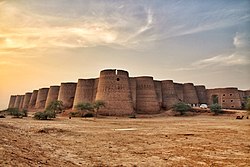
The island is a limestone rock, oval in shape, 800 yards (730 m) long by 300 yards (270 m) wide, and about 25 feet (7.6 m) in height. [2]

The entirety of the island lies within the fort, as the fortification wall encircles the outer perimeter, bordering the Indus River on all sides. Portions of the fortification wall still stand at various points. Several bastions, some of semi-circular and elliptical design, are evident, along with gates of varying sizes, though many of these are now obstructed with rubble stones. The presence of a railway line divides the island into two sections. Throughout its history, the island and fort have exchanged hands numerous times. [5]

History and significance

The origins of the name "Bakhar" remain uncertain. Historical texts such as the Tuhfat al-Kiram suggest that the town did not exist during the Dahir's era nor is its name mentioned in the early Muslim period. However, references to a place called "Baghrur Fort" are found in the Chach Nama, where it is noted that Muhammad bin Qasim encountered this fort during his strategic campaigns. This fort, situated on the opposite side of the Indus River and belonging to Raja Dahir, was administered from the capital city of Aror. [6]

Dr. Nabi Bakhsh suggests that the ancient name "Baghrur Fort" evolved into "Bakhar Fort," located on a mid-river island. Just as the capital city of Aror was named "City on the Rud" during the Sassanid Persia's political dominance, the town founded on the river was named "Baghrur," signifying a gift of the god "Bagh." It appears that during this period, the northern Deltaic Apex was situated northeast of Rohri-Sukkur, with a smaller channel passing through Aror and the main trunk-river flowing between Bakhar island and the hilly formation north of Sukkur city. The main course of the Indus separated the twin cities of Arur and Baghrur, hindering Muhammad bin Qasim's conquest of the Baghrur Fort. [1]

According to historical accounts, the origins of Bakhar fort are traced back to the Arab period. The Tarikh-e-Lubb-e-Sindh suggests that its construction date can be inferred from 'Bala Hisar,' indicating a construction period around 944-45 A.D. Some sources mention that during the reign of Caliph Harun al-Rashid, the fort underwent reconstruction and was renamed "Farishtah". However, Mirza Qaleech Baig claims that Farishtah was founded by Shaikh Abu Turab around 787 A.D. None of these claims are supported by contemporary historical evidence. [1]

According to the Tuhfat al Kiram, the place was named "Bakhar" instead of Farishtah by Sayyid Muhammad Al-Makki, who arrived in Sindh from Yemen around 1246-47 A.D. Legend has it that Sayyid Muhammad Makki, upon arriving at the place, exclaimed, "God has dawned our day in a blessed place," leading to the name Bakra or Baqar, which eventually evolved into Bakhar. [1]

In the 13th century, the historical reference Chach Nama was translated into Persian from Arabic by Ali al-Kufi at Bhakkar. [7]

In the 15th century, the Samma Jam Tughlaq Juna II quelled a Baloch rebellion in the vicinity of Bhakkar, punished its leaders, and appointed his brothers as Governors of Sehwan and Bhakkar to fortify the northern borders of his realm. [8]

The Samma Jam Nizamuddin II swiftly implemented measures upon ascending to the throne to counter the frequent invasions by Baloch tribes into Sindh. These tribes, known for their raids in northern Sindh, had been displacing Sindhi peasants from their lands. Jam Nizamuddin personally resided in Bhakkar for over a year, where he undertook punitive actions against the Baloch tribes. He bolstered the fortifications of Bhakkar, stocked it with provisions, and appointed his slave, Dilshad, to oversee the fort's defense, thereby securing the northern borders of his realm. [9]

After the fall of Samma Dynasty, the Arghun dynasty occupied Bhakkar. Shah Shuja Beg designated Sultan Mahmud Kokaltash, who was fifteen years old at the time, to serve as the administrator of Bhakkar. [10]

After the Arghun dynasty, the Mughal Empire occupied it. [6]

In the 17th century, Bhakkar was popular for its cotton manufacturing industry. [11]

In the 18th century, Mian Noor Mohammad Kalhoro of the Kalhora Dynasty took charge of Bhakkar. [12]

After the end of Kalhora rule, the Talpur dynasty took charge. Later, the British Raj acquired control of the island from the Talpurs through the treaty signed on 24th December, 1838 A.D, renaming it Victoria. However, this new designation failed to gain widespread acceptance, and the island continues to be recognized by its native name. [6]

Related Research Articles

<span class="mw-page-title-main">Sindh</span> Province of Pakistan

Sindh is a province of Pakistan. Located in the southeastern region of the country, Sindh is the third-largest province of Pakistan by land area and the second-largest province by population after Punjab. It is bordered by the Pakistani provinces of Balochistan to the west and north-west and Punjab to the north. It shares an International border with the Indian states of Gujarat and Rajasthan to the east; it is also bounded by the Arabian Sea to the south. Sindh's landscape consists mostly of alluvial plains flanking the Indus River, the Thar Desert of Sindh in the eastern portion of the province along the international border with India, and the Kirthar Mountains in the western portion of the province.

<span class="mw-page-title-main">Sukkur</span> Metropolis in Sindh, Pakistan

Sukkur is a city in the Pakistani province of Sindh along the western bank of the Indus River, directly across from the historic city of Rohri. Sukkur is the third largest city in Sindh after Karachi and Hyderabad, and 14th largest city of Pakistan by population. New Sukkur was established during the British era alongside the village of Sukkur. Sukkur's hill, along with the hill on the river island of Bukkur, form what is sometimes considered the "Gate of Sindh".

<span class="mw-page-title-main">Shikarpur, Sindh</span> City in Sindh, Pakistan

ShikarpurŚikārpūr) is a city and the capital of Shikarpur District in Sindh province of Pakistan. It is situated about 29 km west of the right bank of the Indus, with a railway station, 37 km north-west of Sukkur. It is the 42nd largest city of Pakistan by population according to the 2017 census.

Soomro, Soomra,Sumrah or Sumra is a tribe having a local origin in Sindh. They are found in Sindh, parts of Punjab especially bordering Sindh, Balochistan province, and the Kutch district of the Indian state of Gujarat and also Rajasthan.

The Kalhora is a Sammat Sindhi clan in Sindh, Pakistan.

<span class="mw-page-title-main">Samma dynasty</span> 15th-century dynasty based in Sindh

The Samma dynasty was a medieval Sindhi dynasty ruled by the Samma tribe of Sindh in the Indian subcontinent, that ruled Sindh, as well as parts of Kutch, Punjab and Balochistan from c. 1351 to c. 1524 CE, with their capital at Thatta known as Sammanagar in modern day Sindh, Pakistan; before being replaced by the Arghun dynasty.

The Arghun dynasty ruled over the area between Southern Afghanistan and Sindh from the late 15th century to the early 16th century. Arghun rule can be divided into two branches: the Arghun branch of Dhu'l-Nun Beg Arghun that ruled until 1554, and the Tarkhan branch of Muhammad 'Isa Tarkhan that ruled until 1591.

<span class="mw-page-title-main">Rohri</span> City in Sindh, Pakistan

Rohri is a city of Sukkur District, Sindh province, Pakistan. It is located on the east bank of the Indus River, located directly across from Sukkur, the third largest city in Sindh. Rohri town is the administrative headquarters of Rohri Taluka, and tehsil of Sukkur District with which it forms a metropolitan area. Its capture marked the beginning of Muslim rule in South Asia under Muhammad ibn al-Qasim in 711 CE, when it was named Aror.

<span class="mw-page-title-main">History of Sindh</span>

The history of Sindh refers to the history of the Pakistani province of Sindh, as well as neighboring regions that periodically came under its sway.

Bhurgari is a Baloch tribe which lives in various provinces of Pakistan.

<span class="mw-page-title-main">Makli Necropolis</span> UNESCO World Heritage site in Pakistan

Makli Necropolis is one of the largest funerary sites in the world, spread over an area of 10 kilometres near the city of Thatta, in the Pakistani province of Sindh. The site houses approximately 500,000 to 1 million tombs built over the course of a 400-year period. Makli Necropolis features several large funerary monuments belonging to royalty, various Sufi saints, and esteemed scholars. The site was inscribed as a UNESCO World Heritage Site in 1981 as an "outstanding testament" to Sindhi civilization between the 14th and 18th centuries.

<span class="mw-page-title-main">History of Karachi</span>

The area of Karachi in Sindh, Pakistan has a natural harbor and has been used as fishing port by local fisherman belonging to Sindhi tribes since prehistory. Archaeological excavations have uncovered a period going back to Indus valley civilisation which shows the importance of the port since the Bronze Age. The port city of Banbhore was established before the Christian era which served as an important trade hub in the region, the port was recorded by various names by the Greeks such as Krokola, Morontobara port, and Barbarikon, a sea port of the Indo-Greek Bactrian kingdom and Ramya according to some Greek texts. The Arabs knew it as the port of Debal, from where Muhammad bin Qasim led his conquering force into Sindh in AD 712. Lahari Bandar or Lari Bandar succeeded Debal as a major port of the Indus; it was located close to Banbhore, in modern Karachi. The first modern port city near Manora Island was established during British colonial Raj in the late 19th century.

<span class="mw-page-title-main">Talpur dynasty</span> Sindhi medieval dynasty ruling till 19th century

The Talpur dynasty were rulers based in Sindh, a region of present-day Pakistan. Four branches of the dynasty were established following the defeat of the Kalhora dynasty at the Battle of Halani in 1783: one ruled lower Sindh from the city of Hyderabad, another ruled over upper Sindh from the city of Khairpur, a third ruled around the eastern city of Mirpur Khas, and a fourth was based in Tando Muhammad Khan.

Sindhi literature is the collection of oral and written literature in the Sindhi language in prose and poetry. The Sindhi language of the province of Sindh in Pakistan is considered one of the oldest languages of ancient India, and influenced the language of Indus Valley inhabitants. Sindhi literature has developed over a thousand years.

Hyderābād City (Haidarābād), headquarters of the district of Sindh province of Pakistan traces its early history to Neroon, a Sindhi ruler of the area from whom the city derived its previous name, Neroon Kot. Its history dates back to medieval times, when Ganjo Takker, a nearby hilly tract, was used as a place of worship. Lying on the most northern hill of the Ganjo Takker ridge, just east of the river Indus, it is the third largest city in the province and the eighth largest in the country with an expanse over three hillocks part of the most northerly hills of the Ganjo Takker range, 32 miles east of the Indus with which it is connected by various routes leading to Gidu Bandar.

<span class="mw-page-title-main">Aror</span> Historical capital of Sindh, Pakistan

Aror or Alor or Arorkot is the medieval name of the city of Rohri. Aror once served as the capital of Sindh.

Kakrala was a historical region in southern Sindh, in the coastal parts of the Indus Delta. Descriptions of its precise extent vary, but it lay in the middle part of the delta, comprising the present-day taluqas of Shahbandar and Jati in Sujawal and Thatta districts. It has been described as the region from Jati to Kharo Chan, or the region between the mouths of the Wanyani and Pitti rivers. This area later formed part of the pargana of Ghorabari.

Gandavah is a town that serves as the headquarters of Jhal Magsi District of Pakistan's Balochistan province. Located on a small hill in the middle of the Kach Gandava plain, Gandava is inhabited by a mix of Sindhi, Baloch, Pathan, Brahui, and Hindu communities. The town has a long history and several old architectural monuments including the Moti Gohram tomb, locally known as "the Taj Mahal of Baluchistan". Gandava also faces significant difficulties with needs like water, electricity, gas, healthcare, and education. As of the 2017 Census of Pakistan, Gandava Municipal Corporation has a population of 7,825 people, in 1,256 households.

<span class="mw-page-title-main">Mirza Jani Beg Tarkhan</span> Mirza of Sindh

Mirza Jani Beg Tarkhan was a Mirza (ruler) of Sindh. He succeeded his grandfather Mirza Muhammad Baqi after his death. He ruled from 1585 to 1591 as an independent monarch of Sindh but was forced to submit to Mughal authority. He later involuntarily abdicated in 1593 and a Mughal Subahdar was appointed in his place. But due to social and public unrest, the Mughal authority appointed Jani in his place in 1594. Jani continued to serve as the Mughal Subahdar till his death in 1601.

The Sindhis of Balochistan are Sindhi people living in Balochistan, Pakistan.

References

  1. 1 2 3 4 Hasan 2005, p. 84.
  2. 1 2 Hasan 2005, p. 81.
  3. Khan, Mubarak Ali (2005). Essays on the History of Sindh. p. 127.
  4. Khan, Ansar Zahid (1980). History and Culture of Sind: A Study of Socioeconomic Organization and Institutions During the 16th and 17th Centuries. Royal Book Company. p. 260.
  5. Hasan 2005, p. 82.
  6. 1 2 3 Hasan 2005, p. 83.
  7. Lari 1994, p. 49.
  8. Lari 1994, p. 74.
  9. Lari 1994, p. 79.
  10. Lari 1994, p. 101.
  11. Ali, Mubarak (1993). Sindh Observed: Selection from the Journal of Sindh Historical Society. Gautam Publishers. p. 8.
  12. Lari 1994, p. 144.

Bibliography

Further reading

27°41′43″N68°53′15″E / 27.69528°N 68.88750°E / 27.69528; 68.88750