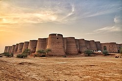
Shagai Fort

Last updated

Shagai Fort is a fort located 13 kilometres from Jamrud in Khyber District, Khyber Pakhtunkhwa, Pakistan. It was built in 1927 by the British forces to oversee the Khyber Pass. The estimated terrain elevation above sea level is 847 metres. It is manned by Pakistani military and paramilitary troops serving as headquarters for the Khyber Rifles [1] — the traditional guardians of the Khyber Pass.

Contents

Trilateral flag meetings among Pakistan, NATO and Afghan military officials are held in this fort. [2]

See also

Related Research Articles

<span class="mw-page-title-main">Malakand Pass</span> Mountain pass in Pakistan

The Malakand Pass is a mountain pass in the Malakand District of Khyber Pakhtunkhwa that connects Peshawar with the Chitral District.

<span class="mw-page-title-main">Khyber Rifles</span> Pakistani paramilitary force

The Khyber Rifles are a paramilitary regiment, forming part of the Pakistani Frontier Corps Khyber Pakhtunkhwa (North). The Rifles are tasked with defending the border with Afghanistan and assisting with law enforcement in the districts adjacent to the border. Raised in the late nineteenth century, the regiment provided the title and setting for the widely read novel, King of the Khyber Rifles, and is the oldest regiment of the Corps. The regiment has a 2020/21 budget of Rs. 1.816 billion(1800 crore PKR) and is composed of seven battalion-sized wings.

<span class="mw-page-title-main">Ali Masjid</span> Mosque in Khyber Pakhtunkhwa, Pakistan

Ali Masjid is the narrowest point of the Khyber Pass. It is located in Khyber District of Khyber Pakhtunkhwa, Pakistan. It is around 10 miles (16 km) east of the city of Landi Kotal and has an elevation of 3,174 feet (967 m). The width of the Khyber near Ali Masjid was earlier too narrow for two fully laden camels to pass each other, but since has been widened.

<span class="mw-page-title-main">Kafir Kot</span> Ruined ancient Buddhist temple complex in Pakistan

Kafir Kot or Kafirkot is an ancient Hindu temple complex in the Dera Ismail Khan district of the Khyber Pakhtunkhwa province of Pakistan. It consists of the ruins of five temples and a large fort. It was an ancient Hindu fort with a famous temple inside its walls. The Kafir Kot complex in Khyber Pakhtunkhwa is often referred to as the "northern Kafir Kot" to distinguish it from the "southern Kafir Kot" that is located in the town of Bilot Sharif, approximately 35 kilometres (22 mi) to the south.

<span class="mw-page-title-main">Abazai</span> Union council and town in Khyber Pakhtunkhwa, Pakistan

Abazai is a town and union council in Charsadda District of Khyber Pakhtunkhwa province of Pakistan. It is part of Tangi Tehsil and is located at 34°19'7''N 71°35'35''E at an altitude of 320 metres (1053 feet), lying to the northwest of the district capital Charsadda and 24 miles north of the provincial capital Peshawar on the left bank of the Swat river, a mile from the river's exit from the hills.

<span class="mw-page-title-main">Shahgai</span> Place in Federally Administered Tribal Areas, Pakistan

Shahgai is a region in Pakistan's Federally Administered Tribal Areas. It was merged into Khyber Pakhtunkhwa in 2018.

<span class="mw-page-title-main">Battle of Ali Masjid</span> 1878 battle of the Second Anglo-Afghan War

The Battle of Ali Masjid, which took place on 21 November 1878, was the opening battle in the Second Anglo-Afghan War between the British forces, under Lieutenant-General Sir Samuel James Browne, and the Afghan forces, under Ghulam Haider Khan. The perceived offence of an Afghan general's refusal to allow a British envoy entrance to the country was used as an excuse to attack the fortress of Ali Masjid, as the opening battle in the war. Despite numerous setbacks, including half the troops getting lost or delayed and missing the battle entirely, the British were lucky that the Afghans abandoned their position overnight.

The 2009 Khyber Pass offensive was an offensive military campaign by Pakistani Army against Islamic militants from Lashkar-e-Islam in and near the Khyber Pass. The offensive was launched after a series of suicide bombings, including one at a police station where 17 cadets were killed. After two months, Pakistan Army defeated the militants and cleared the area from the militants.

<span class="mw-page-title-main">2011 Charsadda bombing</span> Suicide bombing by Islamist militants in Charsadda, Khyber Pakhtunkhwa, Pakistan

A double bombing occurred on 13 May 2011 in Shabqadar Fort in Charsadda District of Khyber Pakhtunkhwa province of Pakistan. 98 people were killed when two suicide bombs exploded in the Frontier Constabulary training centre. At least 140 others were injured. The explosions occurred while cadets were getting into buses for a ten-day leave after a training course.

Peshawar Golf Club also called PAF Golf Course is a golf course located in Peshawar, the capital of Khyber Pakhtunkhwa province of Pakistan. It is located on Grand Trunk (GT) Road, adjacent to Pearl Continental Hotel and Radio Pakistan, Peshawar.

Landi Khana Railway Station is a disused railway station in Khyber Pakhtunkhwa province of Pakistan. It is located near the Pakistani town of Torkham, on the Pakistan-Afghanistan border. It was established on 23 April 1926 during British rule. The railway connecting the station to nearby Landi Kotal was closed on 15 December 1932, at the request of the Afghan government.

Kata Kushta Railway Station is located in Khyber Pakhtunkhwa province of Pakistan. The station is on the discontinued Khyber Pass Railway line and does not have scheduled train services.

Medanak Railway Station is located in Pakistan. It is on the disused Khyber Pass Railway line and does not have scheduled train services.

<span class="mw-page-title-main">Shahgai railway station</span> Railway station in Khyber Pakhtunkhwa, Pakistan

Shahgai Railway Station is located in Shagai, Khyber Pakhtunkhwa, Pakistan. It lies on the Khyber Safari line between Peshawar and Landi Kotal.

Zintara Railway Station is located in Khyber Pakhtunkhwa province of Pakistan. The station is on the discontinued Khyber Pass Railway line.

<span class="mw-page-title-main">Shagai Plateau</span>

Shagai Plateau, also referred to as Shagai Heights is an area of flat lands along the Khyber Pass. Fort Al Creator was nearby. The ascent to the Shagai Plateau begins near the entrance to the Khyber Pass from the southeast at Peshawar in what is now Pakistan. It was the site of a British encampment during the Second Anglo-Afghan War which began in November 1878 when Great Britain, fearful of what it saw as growing Russian influence in Afghanistan, invaded the country from British India. The first phase of the war ended in May 1879 with the Treaty of Gandamak, which permitted the Afghans to maintain internal sovereignty but forced them to cede control over their foreign policy to the British. Fighting resumed in September 1879, after an anti-British uprising in Kabul, and finally concluded in September 1880 with the decisive Battle of Kandahar.

<span class="mw-page-title-main">Ali Masjid Fort</span> Fort in Khyber Pakhtunkhwa, Pakistan

Ali Masjid Fort is situated on a high location above Ali Masjid, the narrowest point of the Khyber Pass, in the Khyber Pakhtunkhwa province on the north west frontier of Pakistan.

<span class="mw-page-title-main">Sphola Stupa</span> Buddhist monument in Khyber Phaktunkhwa, Pakistan

Sphola Stupa is a Buddhist monument located in the Khyber Pass, Khyber Pakhtunkhwa of Pakistan. The monument located about 25 kilometers from Jamrūd is on a high rocky ledge and consists of a stone mound supported by a tiered base. Large sections of the stone have fallen away, particularly to the right of the mound. A man is standing on the top of the mound, and another man is standing on a pile of rubble to the right. There is a valley beyond with steep mountains rising behind it.

Jinnah Park is a public park located in Peshawar city of Khyber Pakhtunkhwa province of Pakistan.

References

  1. Forts of Pashtunkhwa [usurped] Khyber.org. Retrieved 2 October 2021
  2. "Beyond the Bab-e-Khyber - The Express Tribune". tribune. 22 January 2012. Retrieved 5 September 2016.

34°01′02″N71°16′48″E / 34.017350°N 71.279887°E / 34.017350; 71.279887