Jhelum is a city on the East Bank of the Jhelum River, which is located in the district of Jhelum in the North of Punjab, Pakistan. It is the 44th largest city of Pakistan by population. Jhelum is known for providing many soldiers to the British Army before independence, and later to the Pakistan armed forces, due to which it is also known as City of Soldiers or Land of Martyrs and Warriors.

Sohawa is an administrative sub-division (Tehsil) of the Jhelum District, situated in the Punjab province of Pakistan, located in the northwestern part of the district. One sign of Sohawa is the toll plaza by the name of 'Tarakki' on the Grand Trunk Road. The main bazaar of Sohawa attracts people from nearby villages.

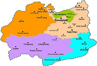
Rawalpindi is a tehsil - an administrative subdivision - of Rawalpindi District in the western part of the Punjab province, Pakistan, it contains the district capital - the city of Rawalpindi.
Kahuta Tehsil is one of the seven tehsils (subdivisions) of Rawalpindi District in the Punjab province of Pakistan. The neighbouring tehsil of Kallar Sayedan used to be part of Kahuta, but was later created as separate tehsil. The name Kahuta was derived from "Koh" a local medicinal tree and "Boota". Perhaps "Koh Boota" was shortened to Kohuta/Kahuta over the passage of time.

Takal is the biggest village in Choha Khalsa Union Council of Kallar Syedan Tehsil, Rawalpindi District of Punjab, Pakistan. Nearby towns include Bewal and Choha Khalsa. The village named after a Sikh – Tikka Lal Singh. It is located about 15 kilometres (9.3 mi) from Kallar Syedan, towards the Jhelum River.
Changa Bangial is a town and Union Council, an administrative subdivision, of Gujar Khan Tehsil in the Punjab Province of Pakistan.
Kallar Syedan is a tehsil in the Rawalpindi District, Punjab, Pakistan. Earlier a part of the Kahuta Tehsil, it became a separate tehsil on 1 July 2004.
Bhata is a village in Pakistan which is located in the centre of Mandra-Chowk Pindori Road, Tehsil Gujar Khan, Rawalpindi District.
Qila Sobha Singh is a town in Narowal District of Punjab province of Pakistan. Before 1 July 1991 it was part of Sialkot District but after 1 July 1991 it was made part of Narowal District. It is part of Narowal District and is located at 32°14′0″N74°46′0″E and has an altitude of 240 metres (790 ft).
Hadwala Gujaran is a village in the Islamabad Capital Territory of Pakistan. It is located at 33° 26' 35N 73° 17' 45E with an altitude of 520 metres (1,710 ft).
Mohra Rajgan is a village in Bhalakhar, Kallar Syedan tehsil, Rawalpindi District, Pakistan. The population of Mohra Rajgan peoples belong to Gakhar tribe.

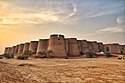
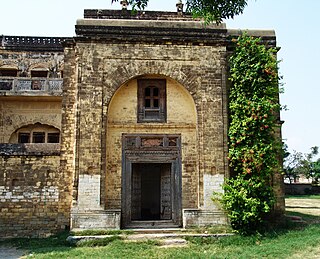
Bedi Mahal, also known as Khem Singh Bedi's Haveli, or simply known as Babay Da Mehal, is a palace situated in Kallar Syedan some 40 kilometres away from Islamabad in Rawalpindi District, Punjab, Pakistan.

Bhura Hayal بھورہ حیال a fairly large village in Tehsil Kahuta with a population of about 15,000 +. It is located about 8 Kilometers from Chowk Pindori on Thoa Khalsa- Matore Road.
Dera Khalsa is a village in the Kallar Syedan Tehsil, Rawalpindi District, Punjab province of Pakistan. The name was given by rulers of this region during Sikh rule in Punjab. This name is still used to refer this village. Presently the entire population of this village is Muslim, having strong religious beliefs and 95% of existing families are migrated from Jammu in 1947. Presently residing families settled in this village in 1951–52.
Choa Khalsa is a town and Union Council of Kallar Syedan Tehsil, Rawalpindi District, Punjab, Pakistan. Town consist of 800 houses. On 1 July 2004, Choa Khalsa became the Union Council.

Khem Singh Bedi KCIE was a claimed direct descendant of Guru Nanak, a leader, and the founder of the Singh Sabha in 1873. It instituted many charitable causes for Sikhs, was a landowner and politician in the Punjab during the British Raj.
Kallar Syedan is a city located in Punjab, Pakistan, and is the headquarters of the Kallar Syedan Tehsil.

Samote Union Council is a union council in Punjab, Pakistan.
Samote is a Town and Capital of Union Council Samote, Tehsil Kallar Syedan, District Rawalpindi Samote is 20 kilometres (12 mi) from Kallar Syedan, 60 kilometres (37 mi) from Rawalpindi City, 70 kilometres (43 mi) from Islamabad, 31 kilometres (19 mi) from Dadyal, 22 kilometres (14 mi) from Gujar Khan.Samote Was Under, NA-50, National Assembly and PP-7, Punjab Assembly In General elections 2008 Samote Was Gon Under PP-2, Punjab Assembly In Next General elections 2018 Samote is Under NA-58, National Assembly and PP-7, Punjab Assembly,Page 12 NA-57.Choha Khalsa
Dhok Baba Faiz Bukhsh is a village situated in the Samote Union Council, Kallar Syedan and Gujarkhan of district Rawalpindi, Punjab, Pakistan. Post Code 47490