Bahawalpur was a princely state in subsidiary alliance with British Raj, and later Dominion of Pakistan, that was a part of the Punjab States Agency. The state covered an area of 45,911 km2 (17,726 sq mi) and had a population of 1,341,209 in 1941. The capital of the state was the town of Bahawalpur.
Multan is a city in Punjab, Pakistan, located on the bank of Chenab River. Multan is one of the five largest urban centres of Pakistan in 2023 and is the major cultural, religious and economic centre of Southern Punjab. Multan is known for its rich ancient heritage and historic landmarks. The city is one of the oldest and continuously inhabited cities of Asia, with a history stretching deep into antiquity. A historic capital, cultural centre of Punjab and a significant cultural centre of Indus Valley civilization. Multan region was centre of many civilizations in its 5 millenia old history.

The Lahore Fort is a citadel in the city of Lahore in Punjab, Pakistan. The fortress is located at the northern end of Walled city of Lahore and spreads over an area greater than 20 hectares. It contains 21 notable monuments, some of which date to the era of Emperor Akbar. The Lahore Fort is notable for having been almost entirely rebuilt in the 17th century, when the Mughal Empire was at the height of its splendor and opulence.

Dera Ismail Khan, abbreviated as D.I. Khan, is a city and capital of Dera Ismail Khan District, located in Khyber Pakhtunkhwa, Pakistan. It is the 37th largest city of Pakistan and fifth largest in the province of Khyber Pakhtunkhwa by population. Dera Ismail Khan is situated on the west bank of the Indus River, at its junction with the Gomal River.
Derajat, the plural of the word 'dera', is a cultural region of central Pakistan, located in the region where the provinces of Punjab, Khyber Pakhtunkhwa, and Balochistan meet. Derajat is bound by the Indus River to the east, and the Sulaiman Mountains to the west.

Rohtas Fort is a 16th-century fortress located near the city of Dina in Jhelum district of the Punjab province of Pakistan. Raja Todar Mal, the minister of the Afghan king Sher Shah Suri, supervised the construction of the fort, which is now one of the largest and most formidable in Punjab.

The Salt Range is a mountain range in the north of Punjab province of Pakistan, deriving its name from its extensive deposits of rock salt. The range extends along the south of the Potohar Plateau and the north of the Jhelum River. The Salt Range contains the great mines of Khewra, Kalabagh and Warcha which yield vast supplies of salt. Coal of a medium quality is also found. The Salt Range starts from the Bakralla and Tilla Jogian ridges in the east and extends to the west of River Jhelum.

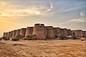
Derawar Fort is a fortress in Ahmadpur East Tehsil of Bahawalpur District in the Punjab, Pakistan. Approximately 20 km south of the city of Ahmedpur East, the forty bastions of Derawar are visible for many miles in the Cholistan Desert. The walls have a perimeter of 1500 metres and stand up to thirty metres high.

Bhopal State was an Islamic principality founded in the beginning of 18th-century India by the Afghan Mughal noble Dost Muhammad Khan. It was a tributary state during 18th century, a princely salute state with 19-gun salute in a subsidiary alliance with British India from 1818 to 1947, and an independent state from 1947 to 1949. Islamnagar was founded and served as the State's first capital, which was later shifted to the city of Bhopal.
Mankera, is the principal town of Mankera Tehsil, an administrative subdivision of Bhakkar District, in the Punjab province of Pakistan. It is situated about 320 km (200 mi) west of the city of Lahore.

Gurramkonda is a village in Annamayya district of the Indian state of Andhra Pradesh. It is the Mandal headquarters of Gurramkonda Mandal. Gurramkonda Fort is one of the oldest fort in the district. Gurramkonda (village) is a village in the Gurramkonda Mandal of the state of Andhra Pradesh, Annamayya district. It is located at a distance of 0 km from the center of the zones, Horamkonda. It is 35 km from the nearest town, Madanapalle. Is also in the distance. As per the 2011 census of India, the village is spread over 3111 hectares with 2501 houses and a population of 10642. The number of males in the village is 5480, the number of females is 5162. The Scheduled Castes population is 511 and the Scheduled Tribes population is 126. The census location code of the village is 595648. [1]. 13.7833 ° N 78.5833 ° E. on the road to Kadapa, Kadapa, Bangalore [2] The sea can reach 647 meters. The town is a tourist hotspot. It is also historically known as Jaffarabad. Located on Kadapa-Bengaluru Road, this horse-hill is a popular tourist attraction with its historical background. It is a communal harmony with the Hindu and Muslim cultures of the day.

Dhaka (Dacca) is one of the oldest inhabited mega cities of the World. The history of Dhaka begins with the existence of urbanised settlements in the area that is now Dhaka dating from the 7th century CE. The city area was ruled by the Hindu Gauda Kingdom, Buddhist and Shaivite Pala Empire before passing to the control of the Hindu Sena dynasty in the 10th century CE. After the Sena dynasty, the city was ruled by the Hindu Deva Dynasty. Dhaka was successively ruled by the Turkic and Afghan governors descending from the Delhi Sultanate, followed by the Bengal Sultanate, before the arrival of the Mughals in 1608. The city became proto-industrialised and declared capital of the Mughal Bengal and commercial (financial) capital of the Mughal India. The Dhaka natural riverine port has a recorded existence since the 16th century CE. Dhaka's strategic riverine location in Bengal made it a hub for Eurasian traders, including Armenians, the Portuguese, French, Dutch and British. The bustling old city was known as the Venice of the East. After Mughals, British ruled the region for 200 years until the independence of India in 1947. After the independence of Bangladesh in 1971, Dhaka became the capital of the new state.

Rawat Fort is an early 15th century fort in the Pothohar plateau of Pakistan, near the city of Rawalpindi in the province of Punjab.
Multan in Punjab province of Pakistan is one of the oldest cities in South Asia, though its exact age has yet to be determined. Multan remained the capital and largest city of Punjab region in late ancient and most of the medieval era. The Multan region was centre of many civilizations throughout its history, and has witnessed warfare across millennia because of its location on a major invasion route between South and Central Asia. Multan reached the height of its splendour during the Arab rule of 9th and 10th century when it was made a separate state, the Emirate of Multan, as it controlled large parts of Punjab and Kashmir. It is famous for its Sufi shrines. Multan province was one of the largest and first-established provinces of the Mughal Empire.

The Munger Fort, located at Munger, in the state of Bihar, India, is built on a rocky hillock on the south bank of the Ganges River. Its history is not completely dated but it is believed that it was built during the early rule of Slave dynasty of India. The Munger town where the fort is situated was under the control of Muhammad bin Tughluq of Delhi. The fort has two prominent hills called the Karnachaura or Karanchaura, and the other a built up rectangular mound deduced to be the location of a citadel of the fort with historical links. The Fort had a succession of Muslim rulers (Khaljis, Tughlaqs, Lodis, Nawabs of Bengal, followed by Mughal rulers, till it was finally acceded to the British by Mir Quasim, after unseating his father-in-law Mīr Jafar on the grounds of old age, for a monetary reward negotiated by Vansittart. This deal involved payment by the East India Company's merchants of an ad valorem duty of 9 percent, against an Indian merchant’s duty of 40%. The fort became a place of considerable importance to the British in Bengal till 1947.

Kila Saifullah District, Qilla Saifullah, or Saifullah Killa is a district in northwestern Balochistan province, Pakistan. It was established as a district in 1988 comprising two former administrative units of Zhob District: the Upper Zhob sub-division and the sub-tehsil of Badinai, previously named Kashatoo and part of the subdistrict of Kakar Khurasan.

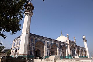
The Badshahi Mosque is an iconic Mughal-era congregational mosque in Lahore, Punjab, Pakistan. The mosque is located opposite of Lahore Fort in the outskirts of the Walled City and is widely considered to be one of Lahore's most iconic landmarks.

The Kingdom of Mankhera and Dera, also known as Mankhera or Leah and Bukkar, was a powerful Indian State that arose under the declining influence of the Mughal Empire and Durrani Empire.
Kusak Fort is an ancient fort located in Chakwal District, Punjab, Pakistan.

Islamgarh Fort, previously known as Bheem War Fort, is a fort situated in the Cholistan Desert, Pakistan.