Chitral District was a district in the Malakand Division of the Pakistani province of Khyber Pakhtunkhwa, from 14 August 1947 to 2018. It was the largest district in the Khyber-Pakhtunkhwa, covering an area of 14,850 km2, before splitting into Upper and Lower Chitral Districts in 2018. It was the northernmost district of Khyber Pakhtunkhwa. It shared a border with Gilgit-Baltistan to the east and with Swat and Dir districts of Khyber Pakhtunkhwa to the south. It also shared an international border with Afghanistan to the north and west. Afghanistan's narrow strip of Wakhan Corridor separated Chitral from Tajikistan in the north.

Chitral is a city situated on the Chitral River in northern area of Khyber Pakhtunkhwa. It serves as the capital of the Lower Chitral District, and was previously the capital of Chitral District, and before that the capital of Chitral princely state. The region was encompassed into West Pakistan between the years 1969 and 1972. It has a population of 49,780 per the 2017 census.
The Kom or Kam are a Nuristani tribe in Afghanistan and Pakistan.
The Katir are a Nuristani tribe in Afghanistan and Pakistan.

The Chitral River, also known in Afghanistan as the Kunar River, is a 480 kilometres (300 mi) long river in northern Pakistan and eastern Afghanistan. It originates from the Chiantar glacier, located at the border of Gilgit Baltistan and Chitral which falls within the Khyber Pakhtunkhwa province of Pakistan. At Arandu it enters into Afghanistan, where it is named as the Kunar River. It later merges with Kabul river in the Nangahar Province of Afghanistan. The river system is fed by melting glaciers and snow of the Hindu Kush mountains. The Chitral River serves as a major a tributary of the Kabul river, which is in turn a tributary of the Indus River.

Yak polo is a Mongolian variant of the sport polo. It is played on yaks instead of on horseback.

The Kho, or Chitrali people, are an Indo-Aryan ethnolinguistic group native to the Chitral District in Khyber Pakhtunkhwa, Pakistan and the Gupis-Yasin and Ghizer districts of Gilgit-Baltistan. They speak an Indo-Aryan language called Khowar.
The Zagaran Pass is a high mountain pass that connects Yarkhun River valley in Chitral District to the Gupis valley in Gilgit-Baltistan.
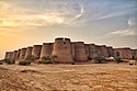
Mastuj is a tehsil of Upper Chitral District in Khyber-Pakhtunkhwa province of Pakistan; Mastuj is the principal settlement. It is located at 36°17'0N 72°31'0E with an altitude of 2359 metres. There are ruins of old fort built originally in 18th century and reconstructed several times.
The Katoor dynasty was a dynasty, which along with its collateral branches ruled the sovereign, later princely state of Chitral and its neighbours in the eastern Hindu Kush region for over 450 years, from around 1570 until 1947. At the height its power under Mehtar Aman ul-Mulk the territory controlled by the dynasty extended from Asmar in the Kunar Valley to Sher Qilla in the Gilgit valley. The Mehtar of Chitral was an influential player in the power politics of the region as he acted as an intermediary between the rulers of Badakhshan, the Yousafzai pashtuns, the Maharaja of Kashmir and later the Amir of Afghanistan.
Khouzh is a village located in Upper Chitral, a district in the Khyber Pakhtunkhwa province of Pakistan. The village is situated between the Koh Hindukush and Hindu Raj mountain ranges, with the Chitral River flowing along its borders. Khouzh is home to a diverse community of people who speak the local language of Khowar. Khouzh is located 130 km from Chitral town.It has surface elevation of 2408 meters.
Charun-Oweer is an isolated village 10 kilometers to the North of Charun in the Mastuj Tehsil of District Chitral District in Pakistan.

Buni is a town and the headquarters of Upper Chitral District in Khyber Pakhtunkhwa, Pakistan.
Charun is an administrative unit, known as Union Council, of Upper Chitral District in the Khyber Pakhtunkhwa province of Pakistan.
Chitral–Shandur Road is a 172-kilometre-long (107 mi) provincial highway which extends from Chitral in Khyber Pakhtunkhwa province to Shandur in Gilgit-Baltistan province, Pakistan. Originally several separate roads, the Pakhtunkhwa Highways Authority merged them together to form one continuous road.

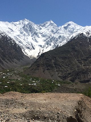
Upper Chitral District is an administrative district in the province of Khyber Pakhtunkhwa, Pakistan. Kho people are the dominant ethnic group in the district, forming 99.84% of the total population.

Bashkargol Lake is a lake located in the upper Chitral Valley at a distance of about 170 kilometres (110 mi) from Chitral town in Chitral District of Khyber Pakhtunkhwa province of Pakistan. The lake is accessible by a four-wheel drive vehicle to the village of Sor Laspur followed by a 20 kilometers hike, and is often utilized for camping on the way to base camp of the peak Thalo Zom or to cross Thalo Pass.
Kuragh is a village located in Chitral district of Khyber Pakhtunkhwa, Pakistan. It falls in Mastuj tehsil.