
The Chenab River is a major river in South Asia, flowing through India and Pakistan, and is one of the 5 major rivers of the Punjab region. It is formed by the union of two headwaters, the Chandra and Bhaga, which rise in the upper Himalayas in the Lahaul region of Himachal Pradesh, India. The Chenab flows through the Jammu region of Indian-administered Jammu and Kashmir, into the plains of Punjab, Pakistan, where it joins the Sutlej River to form the Panjnad, which ultimately flows into the Indus River at Mithankot.

Doda district is an administrative district of the Jammu division of Indian-administered Jammu and Kashmir in the disputed Kashmir region. Doda covers 2,625 square kilometers.
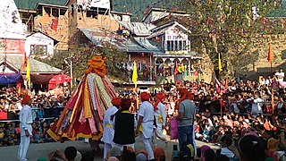
Bhaderwah or Bhadarwah is a town, tehsil, and sub-district in the Doda district of Jammu Division of Jammu and Kashmir, India. Bhaderwah Valley is famous for it's beauty, nature. Bhaderwah valley is known as 'Land Of Snakes'. Bhaderwah is also a land of fairs and festivals like Mela Pat, Subar Dhar Mela, Kud dance, Pahari folk songs and music. It also has heritage sites like the Fort, hundered years old mosque and an ancient Vasuki Nag Temple.
The Tawi is a river that flows through the Jammu region in the Indian-administered Jammu and Kashmir and Pakistan-administered Azad Jammu and Kashmir. The Tawi is a major left bank tributary of the river Chenab.

Jammu and Kashmir is home to several valleys such as the Kashmir Valley, Chenab Valley, Sindh Valley and Lidder Valley. Some major tourist attractions in Jammu and Kashmir are Srinagar, with its renowned Dal Lake and Mughal Gardens, Gulmarg, Pahalgam, Bhaderwah, Patnitop and Jammu. Every year, thousands of Hindu pilgrims visit holy shrines of Vaishno Devi and Amarnath which has had a significant impact on the state's economy.
Chenab Valley is a loosely-defined controversial term sometimes used to refer to parts of the Jammu Division of Jammu and Kashmir, India. The term is used to refer to the present-day districts of Doda, Kishtwar, Ramban, and, at times, Reasi and parts of Udhampur and Kathua. The first three districts used to be part of a single former district called Doda, which was created in 1948 out of the eastern parts of Udhampur district of the princely state of Jammu and Kashmir, and are sometimes collectively referred to as the Doda belt. The term is seen to be aimed at a communal break-up of the Jammu Division and iteration of Kashmiri Muslim irredentism.

The Jammu division is a revenue and administrative division of the Indian-administered Jammu and Kashmir in the disputed Kashmir region. It is bordered by the Kashmir division to the north. It consists of the districts of Jammu, Doda, Kathua, Ramban, Reasi, Kishtwar, Poonch, Rajouri, Udhampur and Samba. Most of the land is hilly or mountainous, including the Pir Panjal Range which separates it from the Kashmir Valley and part of the Great Himalayas in the eastern districts of Doda and Kishtwar. Its principal river is the Chenab.

Thathri is a town and a notified area committee in Doda district in the Indian union territory of Jammu and Kashmir. It is the sub division and tehsil headquarter of Thathri. Thathri valley is located in the foothills of the Himalayan mountains, about 85 km from Batote. Apart from having ample forests, the town contains many small streams flowing through its various parts. It is located on the banks of the Chenab River and the town area is spread over 1.50 sq. Km².
Ababeel (ابابیل), also known as Ababeel NGO, is a charitable trust that provides emergency assistance, disaster relief, food kits, and blood donations for the needy, poor, orphans, widows, and also in emergencies in the Chenab Valley's Doda, Kishtwar, Thathri, Bhaderwah, Bhalessa, Chatroo, Dhadpeth and Jammu. The organization assists people irrespective of caste and religion. It is registered with the Sub Registrar Court Doda.
Saraz or Siraj is a hilly region in the eastern part of the Jammu division of Jammu and Kashmir in northern India. Historically a pargana within the erstwhile state of Kishtwar, the region currently takes up the northern half of Doda district and parts of neighbouring Ramban and Kishtwar districts. Its population in 2011 stood at 180,000 people. The region is defined mainly on the basis of linguistics where the majority of people speak Sarazi as their mother tongue.

Jai Valley is an enchanting valley located 32 kilometres northeast of Bhaderwah town in Jammu and Kashmir, India. The Bhaderwah-Jai road, which passes through the corniferous deodar forests of Nakshri, Balote, Bhalara and Chinta Valley connects the valley with the Bhaderwah town. The valley has green meadows which act as the attraction for tourists in summers and the snow-covered landscape during winters. Jai valley has about 9 kilometres long meadows, bisected by a stream called Jai Nallah which merges with a tributary of river Chenab at Kahara in tehsil Thathri. It is also known by the names Jai Garh and Jai Top. The valley is also connected through a 37 kilometres long road with Gandoh. There is no Mobile Network in this valley.
Chinta Valley is a valley and a village located 20 kilometres northeast of Bhaderwah town on Bhaderwah-Jai road. It is covered with thick coniferous forests from all sides with a stream flowing through it known as Chinta Nallah. A village called Thuba divides the valley from Bhaderwah. Chinta Valley is known for its beauty and it is famous place for tourist.

Bhalessa is a geographical area within Doda district in the Jammu region of India-administered Kashmir. It consists of the Bunjwah and Bhalessa Valleys, and comprises the three Tehsils of Kahara, Chilly Pingal and Gandoh.
Padri Top or Padri Pass is a hill station situated 41 kilometres (25 mi) North of Bhaderwah on [interstate link] Bhaderwah–Chamba National Highway. It has 99.7 kilometres (62.0 mi) long meadows and used for adventure sports like snow-skiing in winters and Paragliding in summers. It is the highest Pass on Bhaderwah-Chamba National Highway located between the borders of Jammu and Kashmir and Himachal Pradesh.
Chattergala Pass, is a mountain pass in the Middle Himalayas of the Jammu region of Jammu and Kashmir, India, connecting the town of Bhaderwah in the Neeru river valley with Basohli in the Shiwalik hills. A road tunnel is planned to be constructed under the pass. The tunnel will be 6.8 km long and will connect Kathua and Doda via Bani. The tunnel is expected to be completed in about 4 years and its construction cost is around Rs. 4,000 crore. The tunnel will facilitate all-weather road connectivity between the regions of Doda and Kathua districts of Jammu and Kashmir. After completion of this tunnel, the travel time from Lakhanpur to Doda would be reduced to four hours.

Sonbain Ashapati is a mountain massif in the Middle Himalayas of Jammu and Kashmir, India, southeast of the town of Bhaderwah near the border with Himachal Pradesh. The Neeru river originates from the Ashapati glacier. The mountain massif lies on the inter-state border between Jammu and Kashmir and Himachal Pradesh, at the trisection of the Doda, Kathua and Chamba districts.
Mahri is a village in Tehsil Thathri of Doda district in Jammu and Kashmir. This village was one of the villages of Chenab Valley which was without electricity till 2022.

Pul Doda is a small township located in Doda district of Jammu and Kashmir. It was once a bustling town until 2008, when it was submerged in the river Chenab due to the rise in water levels caused by the Baglihar Dam.

The Kalnai River is a tributary of the Chenab River in the Bunjwah region bordering Kishtwar and Doda districts in Jammu and Kashmir. An under construction 48MW Lower Kalnai hydroelectric project is located at Donadi on this river.
Gatha is a village located in the Bhaderwah Tehsil in the Doda district of the Indian-administered union territory of Jammu and Kashmir.


