
Doda district is an administrative district of the Jammu division of Indian-administered Jammu and Kashmir in the disputed Kashmir region. Doda covers 2,625 square kilometers.
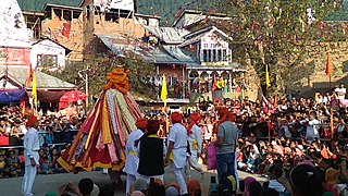
Bhaderwah or Bhadarwah is a town, tehsil, and sub-district in the Doda district of Jammu Division of Jammu and Kashmir, India.
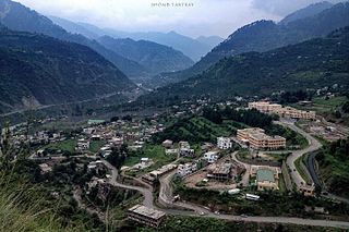
Doda is a town and a notified area committee in Doda district in the Indian union territory of Jammu and Kashmir. Doda has an average elevation of 1,107 metres (3,632 ft).
The administrative divisions of India are subnational administrative units of India; they are composed of a nested hierarchy of administrative divisions.

Samba district is an administrative district in the Jammu division of Indian-administered Jammu and Kashmir in the disputed Kashmir region. It was formed in 2006. Before its formation, this area was part of Jammu district and Kathua district.
Ramban district is an administrative district in the Jammu division of Indian-administered Jammu and Kashmir in the disputed Kashmir region. It is located in a valley surrounded the Pir Panjal range. It was carved out as a separate district from erstwhile Doda district in 2007. It is located in the Jammu division. The district headquarters are at Ramban town, which is located midway between Jammu and Srinagar along the Chenab river in the Chenab valley on National Highway-44, approximately 151 km from Jammu and Srinagar.

Kishtwar district is an administrative district of the Jammu division of Indian-administered Jammu and Kashmir of the disputed Kashmir region. As of 2011, it is the largest and the least populous district of the Union Territory of Jammu and Kashmir.

Chenab Valley is a term refers to present-day districts of Doda, Kishtwar, Ramban in Jammu and Kashmir. These three districts used to be part of a single former district called Doda, which was created in 1948 out of the eastern parts of Udhampur district of the princely state of Jammu and Kashmir, and are sometimes collectively referred to as the Doda belt.

Thathri is a town and a notified area committee in Doda district in the Indian union territory of Jammu and Kashmir. Thathri valley is located in the foothills of the Himalayan mountains, about 85 km from Batote. Apart from having ample forests, the town contains many small streams flowing through its various parts. It is located on the banks of the Chenab River and the town area is spread over 1.50 sq. Km².
Ababeel (ابابیل), also known as Ababeel NGO, is a charitable trust that provides emergency assistance, disaster relief, food kits, and blood donations for the needy, poor, orphans, widows, and also in emergencies in the Chenab Valley's Doda, Kishtwar, Thathri, Bhaderwah, Bhalessa, Chatroo, Dhadpeth and Jammu. The organization assists people irrespective of caste and religion. It is registered with the Sub Registrar Court Doda.
Marmat is a tehsil in the Doda district of Jammu and Kashmir, India. Marmat consists of 18 villages, including the village of Marmat. It is 45 kilometres south of the district headquarters of Doda.

Bhalessa is a geographical area within Doda district in the Jammu region of India-administered Kashmir. It consists of the Bunjwah and Bhalessa Valleys, and comprises the three Tehsils of Kahara, Chilly Pingal and Gandoh.
Chilly Pingal or Chilly Pingle is a tehsil of Doda district in the union territory of Jammu and Kashmir. The Headquarter of the Tehsil is Located at Tandla village.

Bunjwah is a region and tehsil located in the Kishtwar district of Jammu and Kashmir, India. It comprises nine panchayat and two nayabats; it became a tehsil in 2014.
Assar is a tehsil and sub division in the Doda district of Indian-administered Jammu and Kashmir In 2022, Assar became the part of Doda West Assembly constituency.
Mohalla is a village and tehsil in the Doda district of Jammu and Kashmir, India. In 2022, Mohalla became the part of Doda Assembly constituency.
Bhalla is a village and tehsil of Doda district in the union territory of Jammu and Kashmir. Bhalla is located about 15 kilometres from Doda and 25 kilometres from Bhaderwah on the Doda-Bhaderwah Highway.
Mahri is a village in Tehsil Thathri of Doda district in Jammu and Kashmir. This village was one of the villages of Chenab Valley which was without electricity till 2022.
Nandana or Nandna is a village and panchayat in Thathri of Doda district in the union territory of Jammu and Kashmir. Nandana is located in the hilly area of Doda district and have deep gorges.
Halaran is a village and panchayat located in the Kahara tehsil of Doda district in the Indian administered union territory of Jammu and Kashmir. The village is situated approximately 13 kilometers away from the sub-divisional headquarters, Thathri, and 43 kilometers away from the district headquarters, Doda.
