
Thathri is a town and a notified area committee in Doda district in the Indian union territory of Jammu and Kashmir. Thathri valley is located in the foothills of the Himalayan mountains, about 85 km from Batote. Apart from having ample forests, the town contains many small streams flowing through its various parts. It is located on the banks of the Chenab River and the town area is spread over 1.50 sq. Km².
National Highway 244 is a National Highway in India. It is located entirely within the union territory of Jammu and Kashmir. It was originally called National Highway 1B.
Ababeel (ابابیل), also known as Ababeel NGO, is a charitable trust that provides emergency assistance, disaster relief, food kits, and blood donations for the needy, poor, orphans, widows, and also in emergencies in the Chenab Valley's Doda, Kishtwar, Thathri, Bhaderwah, Bhalessa, Chatroo, Dhadpeth and Jammu. The organization assists people irrespective of caste and religion. It is registered with the Sub Registrar Court Doda.
Zea Abad, is a village in Thathri sub division of Doda district. It is the part of panchayat Jangalwar located on the Batote-Kishtwar National Highway.

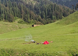
Jai Valley is an enchanting valley located 32 kilometres northeast of Bhaderwah town in Jammu and Kashmir, India. The Bhaderwah-Jai road, which passes through the corniferous deodar forests of Nakshri, Balote, Bhalara and Chinta Valley connects the valley with the Bhaderwah town. The valley has green meadows which act as the attraction for tourists in summers and the snow-covered landscape during winters. Jai valley has about 9 kilometres long meadows, bisected by a stream called Jai Nallah which merges with a tributary of river Chenab at Kahara in tehsil Thathri. It is also known by the names Jai Garh and Jai Top. The valley is also connected through a 37 kilometres long road with Gandoh. There is no Mobile Network in this valley.
Chinta Valley is a valley and a village located 20 kilometres northeast of Bhaderwah town on Bhaderwah-Jai road. It is covered with thick coniferous forests from all sides with a stream flowing through it known as Chinta Nallah. A village called Thuba divides the valley from Bhaderwah.
Bhal Padri is a hill station situated above a group of small valleys covered with a dense forest located in the Changa, Bhalessa. area of Doda district. It borders Padri Pass, Bhaderwah at a distance of 4 kilometres (2.5 mi) northeast. Rivulets and streams flow through this valley.

Bhalessa is a geographical area within Doda district in the Jammu region of India-administered Kashmir. It consists of the Bunjwah and Bhalessa Valleys, and comprises the three Tehsils of Kahara, Chilly Pingal and Gandoh.

Kahara is a village and tehsil in the Doda district of the Jammu division of the Indian union territory of Jammu and Kashmir. It is situated between mountainous cliffs 13 kilometres (8.1 mi) from Thathri on the Thathri-Gandoh road.
Donadi is a village in Kahara tehsil of Doda district in the Indian union territory of Jammu and Kashmir. It is famous for a hydroelectric power project called Lower Kalnie Power Project Donadi.

Bunjwah is a region and tehsil located in the Kishtwar district of Jammu and Kashmir, India. It comprises nine panchayat and two nayabats; it became a tehsil in 2014.
Joura is a village located in the Thatri Block of the Doda district in Jammu and Kashmir. The area is divided into two panchayats called Joura Khurd and Joura Kalan.
Badanoo is a village in Thathri tehsil of Doda district in Jammu and Kashmir. It is located at least 36 kilometres from its district headquarters. This village is the part of Patwar Halqa Jangalwar.
Jangalwar is a village and panchayat in the Thathri tehsil of Doda district in the Jammu division of Jammu and Kashmir, India.
Shibnote is a village in Thathri sub-division of Doda district in Jammu and Kashmir.
Mahri is a village in Tehsil Thathri of Doda district in Jammu and Kashmir. This village was one of the villages of Chenab Valley which was without electricity till 2022.
Nandana or Nandna is a village and panchayat in Thathri of Doda district in the union territory of Jammu and Kashmir. Nandana is located in the hilly area of Doda district and have deep gorges.
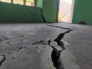
On 1 February 2023, a land subsidence event developed in the town of Thathri in the Doda district of Jammu and Kashmir, India, resulting in 23 structures being declared unsafe and approximately 300 people being displaced. The event has been described by geological experts as a multifactor landsliding. Buildings impacted include several houses, a mosque, a religious school for girls, and a cricket academy. As of 9 February 2023, a massive landsliding was reported at Nayi Basti which blocked National Highway 244 for hours. As of 23 March 2023, the incident spot is declared as "not habitable" by Geological Survey of India report.
Thathri–Gandoh National Highway is a 30-kilometre (19 mi) road that connects Thathri to Gandoh, located in the Doda district of Jammu and Kashmir, India. The road serves as a lifeline for the people living in the Bhalessa region as it provides access to various link roads leading to rural and far-flung areas. In 2022, this road was declared a National Highway by Lieutenant Governor of Jammu and Kashmir Manoj Sinha.
Halaran is a village and panchayat located in the Kahara tehsil of Doda district in the Indian administered union territory of Jammu and Kashmir. The village is situated approximately 13 kilometers away from the sub-divisional headquarters, Thathri, and 43 kilometers away from the district headquarters, Doda.

