
Doda district is an administrative district of the Jammu division of Indian-administered Jammu and Kashmir in the disputed Kashmir region. Doda covers 2,625 square kilometers.
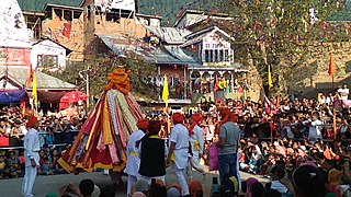
Bhaderwah or Bhadarwah is a town, tehsil, and sub-district in the Doda district of Jammu Division of Jammu and Kashmir, India.
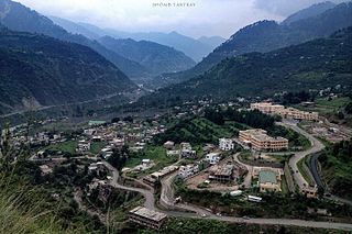
Doda is a town and a notified area committee in Doda district in the Indian union territory of Jammu and Kashmir. Doda has an average elevation of 1,107 metres (3,632 ft).

Bijbehara (Urdu pronunciation:[biːd͡ʒbɪɦɑːɽɑː], known as Vejibror in Kashmiri, is a town and a notified area committee in Anantnag district of the Indian administered union territory of Jammu and Kashmir. It is located on NH 44, and jehlum bank. Bijbehara town is also known as "Town of Chinars" because of a number of Chinars there especially two Chinar gardens. Bijbehara is the home to oldest chinar tree in the region. The town is situated about 45 km from the summer capital of union territory of Jammu and Kashmir, Srinagar.
Ramban district is an administrative district in the Jammu division of Indian-administered Jammu and Kashmir in the disputed Kashmir region. It is located in a valley surrounded the Pir Panjal range. It was carved out as a separate district from erstwhile Doda district in 2007. It is located in the Jammu division. The district headquarters are at Ramban town, which is located midway between Jammu and Srinagar along the Chenab river in the Chenab valley on National Highway-44, approximately 151 km from Jammu and Srinagar.

Kishtwar district is an administrative district of the Jammu division of Indian-administered Jammu and Kashmir of the disputed Kashmir region. As of 2011, it is the largest and the least populous district of the Union Territory of Jammu and Kashmir.

Chenab Valley is a term refers to present-day districts of Doda, Kishtwar, Ramban in Jammu and Kashmir. These three districts used to be part of a single former district called Doda, which was created in 1948 out of the eastern parts of Udhampur district of the princely state of Jammu and Kashmir, and are sometimes collectively referred to as the Doda belt.

Thathri is a town and a notified area committee in Doda district in the Indian union territory of Jammu and Kashmir. Thathri valley is located in the foothills of the Himalayan mountains, about 85 km from Batote. Apart from having ample forests, the town contains many small streams flowing through its various parts. It is located on the banks of the Chenab River and the town area is spread over 1.50 sq. Km².

Kumar Mohalla is a part of Akingam village in Anantnag district of Jammu and Kashmir and a part of tehsil Akingam. It enroutes Kashmir's best-known tourist resorts such as Achabal, Kokernag and Daksum. On one side of Kumar Mohalla Akingam there is a craft centre. Kumar Mohalla Akingam is known for earthenware.
Breswana is a remote Himalayan village in the Doda district of the Jammu division of Jammu and Kashmir, India. The village is located 7,500 feet (2,300 m) above sea level. Breswana village is accessed via trails from Premnagar, the closest town. Kashmiri is the main language of the area. People also use Urdu as a secondary language.
Narbal is a town, tehsil, and block in central Kashmir’s Budgam district of the Union Territory of Jammu and Kashmir, India. It is often referred to as the Gateway of Gulmarg, as it is the first town on the road leading to the famous hill station. Narbal is 13 km from Lal Chowk, the commercial hub of Srinagar, the summer capital of Jammu and Kashmir and located 31 km from the district headquarters Budgam.
Bhagwah is a Tehsil in Doda district of the Indian union territory of Jammu and Kashmir. The town is located 14 kilometres from the district headquarters Doda.

Bhalessa is a geographical area within Doda district in the Jammu region of India-administered Kashmir. It consists of the Bunjwah and Bhalessa Valleys, and comprises the three Tehsils of Kahara, Chilly Pingal and Gandoh.
Badanoo is a village in Thathri tehsil of Doda district in Jammu and Kashmir. It is located at least 36 kilometres from its district headquarters. This village is the part of Patwar Halqa Jangalwar.
Bhella is a tehsil in the Doda district of Jammu and Kashmir. It was previously part of the Thathri tehsil. In 2022, Bhella became the part of Bhaderwah Assembly constituency.
Assar is a tehsil and sub division in the Doda district of Indian-administered Jammu and Kashmir In 2022, Assar became the part of Doda West Assembly constituency.
Kastigarh is a village and tehsil in Doda district of the Jammu division of Jammu and Kashmir, India. In 2022, Kastigarh became the part of Doda West Assembly constituency.
Doda West Assembly constituency is one of the 90 constituencies in the Jammu and Kashmir Legislative Assembly of Jammu and Kashmir a north state of India. Doda West is also part of Udhampur Lok Sabha constituency. This constituency was created in 2022 after delimitation process in Jammu and Kashmir. In May 2022, the final list of new assembly constituencies was published in the gazette. The new constituency consists of Marmat, Assar, Kastigarh, and Bhagwah tehsils; Doda tehsil, Arnora, Dhar, Doda MC, Udhyanpur (part), and Dhara PCs.
Bharat Bagla or Bagla Bharat is a village and tehsil of Doda district in the union territory of Jammu and Kashmir. Bharat Bagla is one of the far flung area in Doda district.
Mahri is a village in Tehsil Thathri of Doda district in Jammu and Kashmir. This village was one of the villages of Chenab Valley which was without electricity till 2022.
