Islas de Gigantes

Last updated
Islas de Gigantes
North-South Gigante.JPG
North and South Gigante Islands seen from the Visayan Sea
Philippines relief location map (square).svg
Red pog.svg
Islas de Gigantes
Location within the Philippines
Geography
Coordinates 11°35′39″N123°20′11″E / 11.59417°N 123.33639°E / 11.59417; 123.33639 Coordinates: 11°35′39″N123°20′11″E / 11.59417°N 123.33639°E / 11.59417; 123.33639
Adjacent bodies of water
Total islands10
Major islands
Administration
Region Western Visayas
Province Iloilo
Municipality Carles
Barangays
  • Gigantes Norte:
    • Asluman
    • Granada
  • Gigantes Sur:
    • Gabi
    • Lantangan
Demographics
Population12,224 (2010)

Islas de Gigantes (Spanish: Gigantes Islands lit: Giant Islands) (variously Islas Gigantes, Higantes group, or Gigantes group) is an island chain within the larger Western Visayas archipelago in the Visayan Sea. It is part of the municipality of Carles, Iloilo, Philippines, and the northernmost part of Iloilo province. The Gigantes islands consist of about ten islands; the two largest are Gigantes Norte (North Gigantes) and Gigantes Sur (South Gigantes). According to the 2010 census, it has a population of 12,224. [1] There is also a lighthouse on Gigantes Norte.

Contents

Location and geography

The Gigantes islands are located roughly 18 kilometres (11 mi) from Panay Island in the Visayan Sea. Gigantes Norte is 213 metres (699 ft) at its highest point, while Gigantes Sur is 232 metres (761 ft) at its highest point. A narrow 800-metre-wide (0.5 mi) channel separates the two islands. [2] Nearby islands include Balbagon Island, which is 6 kilometres (3.7 mi) west of Gigantes Sur and is part of barangay Lantangan.

In addition to the two main islands, the Gigantes group includes the following minor islets: Bulubadiang, Gigantillo, and Gigantuna are islets southeast of Gigantes Norte, while Antonia, Bantigui, Cabugao, Tanguingui, and Turnina are islands and islets south of Gigantes Sur. [2]

The Gigantes group consists of the following four barangays. On Gigantes Norte is Asluman and Granada and on Gigantes Sur is Lantangan and Gabi.

History

The Gigantes group used to be called Sabuluag, or Salauag, which is the name of a species of tree endemic to the islands. During the Spanish colonial era, the name was changed to Gigantes. Local legend describes coffins found inside Bakwitan Cave that contained gigantic sets of human bones, which constituted the name change. [3] For this reason, locals also believe the island is inhabited by engkantos.

A lighthouse was built on Gigantes Norte some time before 1895. Designated ARLHS PHI-094, the white 38-foot-high (12 m) tower features a keeper's house and a focal point 77 feet (23 m) in the air, which flashes once every ten seconds. [4] Lantangan Elementary School in Gigantes Sur has a student population of 1,144, which is higher than the populations of mainland schools. [5]

Typhoons

Typhoon Fengshen, known in the Philippines as Frank, struck the Gigantes group in June 2008. Fengshen destroyed the original lighthouse on Gigantes Norte, which was one of the original 27 lighthouses built by the Spanish in the Philippines. [6] Japan donated a replacement tower, which is made of iron and solar powered. The brick keeper's house is all that remains of the original structure.

Typhoon Haiyan, known in the Philippines as "Yolanda", passed over the Gigantes group, along with the rest of Panay, on November 8, 2013, [7] damaging houses and boats. Unofficial reports stated more than 90 percent of the houses on Gigantes were destroyed. [8] The typhoon also tore the roof off of Lantangan Elementary School in Gigantes Sur. As of June 2014, the roof of the school had not yet been repaired. [5] Many groups conducted relief missions to the Gigantes group, including the Bureau of Fisheries and Aquatic Resources in Region 6 (BFAR-6), the Department of Social Welfare and Development (DSWD-6), RockEd Philippines-RockEd Iloilo, the ABS-CBN Foundation, Loma Linda University Health (LLUH), and the Adventist Development and Relief Agency (ADRA). [9] [10] In June 2014, Save the Children donated more than a thousand bags of school supplies to students on the island. [5] Aside from food and clothing, the fishing community also asked relief organizations to help rebuild their livelihoods. [11]

Points of interest

Points of interest in the Gigantes group include the Cabugao Gamay Island, Antonia Island, Bantigue Sand Bar, and Bakwitan Cave, one of 73 caves throughout the islands.

Tangke

Tangke lagoon Floating Happiness at Tangke Salt Water Lagoon Iloilo.jpg
Tangke lagoon

Tangke is a saltwater lagoon located within Gigantes Sur. It is surrounded by cliffs. One local myth surrounding Tangke states that the waters would magically rise every year on June 24 during the feast of Saint John the Baptist.

North Gigantes Island lighthouse

The station was established during 1895 as one of the Spanish lighthouse projects to be built across the Philippines. The current medium-sized lighthouse that is solar-powered, like most of the lighthouses built today, was donated by Japan to replace the one built by the Spanish government due to the destruction brought by Typhoon Frank in 2008. The keeper's house survived but in ruins. The masonry walls were painted white while the roof is made out of corrugated galvanized iron sheet in red paint finish. [4]

Cabugao Gamay

A small island featuring a white sand beach and an observation deck. [12]

Antonia Beach

The private beach which belongs to a resort (Antonia Resort) on the south eastern tip of Gigantes Sur, known for its 1 peso scallops. [13]

Transport

via Carles

Boats can be chartered from Bancal Port in Carles. [14] Public ferries leave daily from Bancal Port to either Gigantes Norte or Gigantes Sur. Private boats can also be chartered to reach the islands. It takes approximately an hour from Bancal Port to Gigantes islands.

via Estancia

Daily trips are also available from the port of Estancia, which can be reached via point-to-point bus operated by Ceres from their terminal just outside Iloilo City. The single trip leaves at approximately 1300 hours daily and takes about 1.5-2 hours to complete.

See also

Related Research Articles

Iloilo Province in Western Visayas, Philippines

Iloilo, officially the Province of Iloilo, is a province in the Philippines located in the Western Visayas region. Its capital is the City of Iloilo, the regional center of Western Visayas. Iloilo occupies a major southeast portion of the Visayan island of Panay and is bordered by the province of Antique to the west, Capiz to the north, the Jintotolo Channel to the northeast, the Guimaras Strait to the east, and the Iloilo Strait and Panay Gulf to the southwest.

Panay, Capiz Municipality of the Philippines in the province of Capiz

Panay, officially the Municipality of Panay, is a 3rd class municipality in the province of Capiz, Philippines. According to the 2020 census, it has a population of 48,890 people. 

Carles, Iloilo Municipality of the Philippines in the province of Iloilo

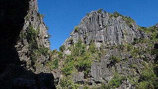
Carles, officially the Municipality of Carles, is a 2nd class municipality in the province of Iloilo, Philippines. According to the 2020 census, it has a population of 72,637 people. 

Pavia, Iloilo Municipality in Western Visayas, Philippines

Pavia, officially the Municipality of Pavia, is a 2nd class municipality in the province of Iloilo, Philippines. According to the 2020 census, it has a population of 70,388 people. 

Oton Municipality of the Philippines in the province of Iloilo

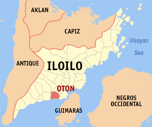
Oton, officially the Municipality of Oton, is a 1st class municipality in the province of Iloilo, Philippines. According to the 2020 census, it has a population of 98,509 people making it as the most populous town in the province and the entire Panay island. 

Santa Barbara, Iloilo Municipality in Western Visayas, Philippines

Santa Barbara, officially the Municipality of Santa Barbara, is a 2nd class municipality in the province of Iloilo, Philippines. According to the 2020 census, it has a population of 67,630 people. 

The Hiligaynon people, often referred to as Ilonggo people or Panayan people, are a Visayan ethnic group whose primary language is Hiligaynon, an Austronesian language of the Visayan branch native to Panay, Guimaras, and Negros. Over the years, inter-migrations and intra-migrations have contributed to the diaspora of the Hiligaynons to different parts of the Philippines. Today, the Hiligaynon form the majority in the provinces of Iloilo, Negros Occidental, Guimaras, Capiz, South Cotabato, Sultan Kudarat, and North Cotabato.

Igbon Island

Igbon Island is an island and barangay in northeastern Iloilo, Philippines. It is part of the municipality of Concepcion. According to the 2010 census, it has a population of 2,547. The island is moderately known in the Philippines for its scuba diving.

Pan de Azucar Island (Iloilo)

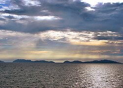
Pan de Azucar, variously known as Tampisaw Island or Tambaliza, is a populated island in the Visayan Sea in the Philippines. The island is known for MountPan de Azucar a steep volcanic cone and a prominent landmark at the northern entrance of Guimaras Strait.

Bayas Island is a small island and barangay in northeastern Iloilo, Philippines. It is part of the municipality of Estancia. According to the 2010 census, it has a population of 2,316. The Island was titled to Filomena Reyes Aclaro and is now shared to the locals.

Loguingot is a small island-barangay in northeastern Iloilo, Philippines. It is part of the municipality of Estancia. According to the 2010 census, it has a population of 796. Fishing is the main source of income for the island's residents.

Danao-Danao Island is a small, low-lying island in northeastern Iloilo, Philippines. It is part of the municipality of Concepcion.

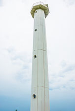
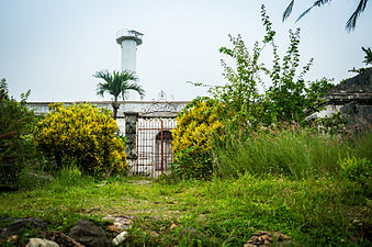
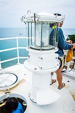
Baliguian Island is an inhabited island in northeastern Iloilo, Philippines. It is the westernmost of the Concepcion Islands and politically administered by the municipality of Concepcion. A virtually flat island, Baliguian features a lighthouse to aid in ship navigation.

Magalumbi is an island in northeastern Iloilo, Philippines. It is part of the municipality of Batad, although the official provincial government website lists it as an offshore island of Estancia. Magalumbi is part of barangay Tanao, which has a population of 1,903 according to the 2010 census.

Manlot is an uninhabited island-barangay in northeastern Iloilo, Philippines. It is one of fourteen islands politically administered by the municipality of Carles.

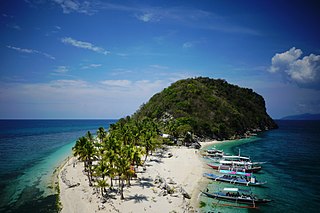
Balbagon is a teardrop-shaped island in northeastern Iloilo, Philippines. It is one of fourteen islands politically administered by the municipality of Carles. There is a small beach resort on the island.

Cabugao Island

Cabugao is a small, uninhabited island in northeastern Iloilo, Philippines. It is one of fourteen islands politically administered by the municipality of Carles. Along with Bantigui Island and Antonia Island, it is one of three minor southern islets in the Islas de Gigantes archipelago.

Tanguingui is a small, uninhabited island in the Visayan Sea of the Philippines. The island is under the jurisdiction of the municipality of Madridejos, Cebu. There is a lighthouse on the island.

References

  1. National Statistics Office. 2010 Census of Population and Housing (PDF). p. 61. Archived from the original (PDF) on November 15, 2012. Retrieved June 7, 2014.
  2. 1 2 National Geospatial-Intelligence Agency (2008). Sailing Directions (Enroute) Philippine Islands (PDF) (7th ed.). Bethesda, Maryland: National Geospatial-Intelligence Agency. p. 94. Archived (PDF) from the original on April 2, 2013. Retrieved June 19, 2014.
  3. "Isla de Gigantes -- Newest Hidden Paradise in the Philippines". CNN iReport. June 19, 2013. Archived from the original on December 25, 2013. Retrieved December 24, 2013.
  4. 1 2 Rowlett, Russ. "Lighthouses of the Philippines: Panay and Guimaras". The Lighthouse Directory. University of North Carolina at Chapel Hill.
  5. 1 2 3 Tayona, Alfred John; Villa, Hazel P. (June 21, 2014). "Yolanda-Ravaged School in North Iloilo Still Roofless". Yahoo News. Archived from the original on July 14, 2014. Retrieved July 2, 2014.
  6. Rowlett, Russ. "Spanish Lighthouses of the Philippines". The Lighthouse Directory. University of North Carolina at Chapel Hill . Retrieved July 1, 2014.
  7. ""Typhoon 'Yolanda' Destroys Several Towns in Iloilo"". CBCP News. November 12, 2013. Archived from the original on November 11, 2014.{{cite news}}: CS1 maint: unfit URL (link)
  8. "Holiday Turns Into Helping Mission". ABC News. December 10, 2013. Archived from the original on December 26, 2013. Retrieved December 24, 2013.
  9. Atienza, Herbert (December 13, 2013). "Loma Linda University Health Disaster Response Team Joins with Adventist Development and Relief Agency to Help in Super Typhoon Haiyan Recovery Efforts in Philippines". PRWeb. Archived from the original on December 21, 2013. Retrieved December 24, 2013.
  10. "Visayas Newsbits for November 19, 2013". Manila Bulletin. November 18, 2013. Archived from the original on December 26, 2013. Retrieved December 24, 2013.
  11. Yap, Tara (December 1, 2013). "Fishermen Need Help with Boats". Manila Bulletin. Archived from the original on March 6, 2014. Retrieved February 24, 2014.
  12. "The Internet Famous Cabugao". unofficialguide.ph. Archived from the original on February 13, 2018. Retrieved June 26, 2017.
  13. "Island Hopping in Gigantes Sur". unofficialguide.ph. Archived from the original on February 13, 2018. Retrieved June 12, 2017.
  14. Muzones, Gem. "Islas de Gigantes Iloilo Island Hopping Guide: Best Time to Go, How to Go, Where to Stay, Itinerary". Guide to the Philippines. Archived from the original on May 24, 2022. Retrieved August 10, 2022.