
The Chafarinas Islands, also spelled Zafarin, Djaferin or Zafarani, are a group of three small Spanish islets located in the Alboran Sea off the coast of Morocco with an aggregate area of 0.525 square kilometres (0.203 sq mi), 45 km (28.0 mi) to the east of Nador and 3.3 km (2.1 mi) off the Moroccan town of Ras Kebdana.
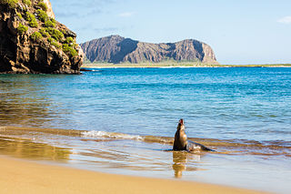
The Galápagos Islands are an archipelago of volcanic islands in the Eastern Pacific, located around the Equator 900 km (560 mi) west of the mainland of South America. They form the Galápagos Province of the Republic of Ecuador, with a population of slightly over 33,000 (2020). The province is divided into the cantons of San Cristóbal, Santa Cruz, and Isabela, the three most populated islands in the chain. The Galápagos are famous for their large number of endemic species, which were studied by Charles Darwin in the 1830s and inspired his theory of evolution by means of natural selection. All of these islands are protected as part of Ecuador's Galápagos National Park and Marine Reserve.

An islet is generally a small island. Definitions vary, and are not precise, but some suggest that an islet is a very small, often unnamed, island with little or no vegetation to support human habitation. It may be made of rock, sand and/or hard coral; may be permanent or tidal ; and may exist in the sea, lakes, rivers or any other sizeable bodies of water.

The Babuyan Islands, also known as the Babuyan Group of Islands, is an archipelago in the Philippines, located in the Luzon Strait north of the main island of Luzon and south of Taiwan via Bashi Channel to Luzon Strait. The archipelago consists of five major islands and their surrounding smaller islands. These main islands are, counterclockwise starting from northeast, Babuyan, Calayan, Dalupiri, Fuga, and Camiguin. The Babuyan Islands are separated from Luzon by the Babuyan Channel, and from the province of Batanes to the north by the Balintang Channel.

Iloilo, also called Iloilo Province, officially the Province of Iloilo, is a province in the Philippines located in the Western Visayas region. Its capital and largest city is Iloilo City, the regional center of Western Visayas and politically independent from the province. Iloilo occupies the southeast portion of the Visayan island of Panay and is bordered by the province of Antique to the west, Capiz to the north, the Jintotolo Channel to the northeast, the Guimaras Strait to the east, and the Iloilo Strait and Panay Gulf to the southwest.

The Jason Islands are an archipelago in the Falkland Islands, lying to the far north-west of West Falkland. Three of the islands, Steeple Jason, Grand Jason and Clarke's Islet, are private nature reserves owned by the Wildlife Conservation Society of New York City. Other islands in the group are National Nature Reserves owned by the Falkland Islands Government.

The Federal Dependencies of Venezuela encompass most of Venezuela's offshore islands in the Caribbean Sea and the Gulf of Venezuela, excluding those islands that form the State of Nueva Esparta and some Caribbean coastal islands that are integrated with nearby states. These islands, with a total area of 342 square kilometres, are sparsely populated – according to the preliminary results of the 2011 Census only 2,155 people live there permanently, with another hundred from Margarita Island who live there seasonally to engage in fishing. Local government is officially under the authority of Central government in Caracas, although de facto power is often held by the heads of the sparse and somewhat isolated communities that decorate the territories.
Carles, officially the Municipality of Carles, is a 2nd class municipality in the province of Iloilo, Philippines. According to the 2020 census, it has a population of 72,637 people.

The Spanish Virgin Islands, formerly called the Passage Islands, commonly known as the Puerto Rican Virgin Islands, consist of the islands of Vieques and Culebra, located between the main island of Puerto Rico and the U.S. Virgin Islands in the northeastern Caribbean. Located between the Greater and Lesser Antilles, the islands are administratively part of the archipelago of Puerto Rico, and geographically part of the archipelago of the Virgin Islands of the Leeward Islands in the Lesser Antilles.
The Las Aves Archipelago is a pristine archipelago in the Caribbean Sea, and is a part of the Federal Dependencies of Venezuela. It is located north of the Venezuelan states of Aragua and Carabobo, between the Dutch island Bonaire in the west, and the Los Roques Archipelago in the east, at 12°00′N67°40′W. The prime economic importance of the islands lies in fishing. "Las Aves" translates to "The Birds" in English.
Los Testigos Islands are a group of islands in the southeastern Caribbean Sea. They are a part of the Dependencias Federales of Venezuela.

Scorpion Reef is an atoll containing a small group of islets in the Gulf of Mexico, about 125 kilometres off the northern coast of the state of Yucatán, Mexico. Designated a national park, the reef is part of the Campeche Bank archipelago and is the largest reef in the southern Gulf of Mexico. It contains five main vegetated islands: Isla Pérez, Isla Desertora, Isla Pájaros, Isla Chica, and Isla Desterrada. Isla Pérez is the only inhabited island and includes a lighthouse. The reef, including its islets and surrounding waters, has been recognised as an Important Bird Area by BirdLife International because it supports a population of magnificent frigatebirds.

The Quiniluban Group is a group of islands in Palawan Province of the Philippines situated between the islands of Palawan and Panay in the Sulu Sea. The group is the northernmost in the Cuyo Archipelago, consisting of several islands and rocks. The easternmost of which is a circular group of islands surrounded by reef about 6 nautical miles in diameter. The largest of the circular group is Quiniluban Island. The island group also includes the upscale resort island of Pamican located about 5.6 nautical miles southwest of the circular group, and Manamoc Island located 3.0 nautical miles further southwest of Pamilacan.

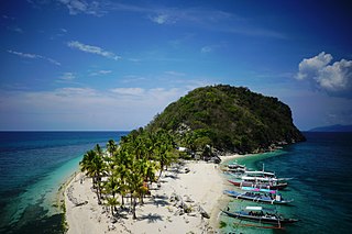
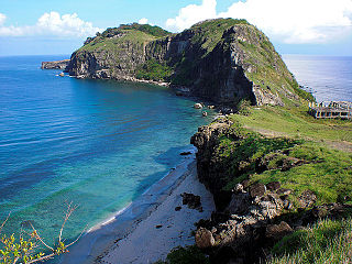
Islas de Gigantes is an island chain within the larger Western Visayas archipelago in the Visayan Sea. It is part of the municipality of Carles, Iloilo, Philippines, and the northernmost part of Iloilo province. The Gigantes islands consist of about ten islands; the two largest are Gigantes Norte and Gigantes Sur. According to the 2020 census, it has a population of 14,332 residents. There is also a lighthouse on Gigantes Norte.
Balbagon is a teardrop-shaped island in northeastern Iloilo, Philippines. It is one of fourteen islands politically administered by the municipality of Carles. There is a small beach resort on the island.
Tanguingui is a small, uninhabited island in the Visayan Sea of the Philippines. The island is under the jurisdiction of the municipality of Madridejos, Cebu. There is a lighthouse on the island.
Capones Island, also known as Grand Capon or Capon Grande Island is a small island approximately 1.9 kilometers (1.2 mi) long by 0.4 kilometers (0.25 mi) wide, at its widest point, lying some 3.8 kilometers (2.4 mi) off the coast of the province of Zambales on western Luzon island in the Philippines. It is the largest of the Capones Islands, a group of three small islands which also includes nearby Camara Island and another islet connected to it by a sand bar. The island is administratively part of barangay Pundaquit of the Zambales municipality of San Antonio.

The Palomino Islands, also called Palominos Islets are a group of small islands off the coast of Callao, Peru. Home to a large population of sea lions and seabirds, it has become a popular tourist area.

