Makonde District

Last updated

Makonde District
Mashonaland West districts.png
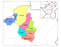
Makonde District in Mashonaland West Province
Country Zimbabwe
Province Mashonaland West
Area
  Total8,564 km2 (3,307 sq mi)
Population
 (2022 census)
  Total209,960
  Density25/km2 (63/sq mi)

Makonde District is a district in Zimbabwe.

Location

The district is located in Mashonaland West Province, in north central Zimbabwe. Its main town, Chinhoyi, with an estimated population of 61,739 people in 2004, [1] is located about 125 kilometres (78 mi), by road, northwest of Harare, the capital of Zimbabwe and the largest city in that country. [2]

Contents

Overview

Makonde District is a farming district. Crops grown here include cotton, maize and tobacco. Cattle are also raised in the district for dairy products and beef on a commercial basis. Mining of copper also takes place.

Chinhoyi, the district headquarters is a college town, hosting two major universities, namely: Chinhoyi University of Technology (CUT) and Zimbabwe Open University (ZOU). There are three major high schools; Chinhoyi High School, Nemakonde High School and Lomagundi College. In addition the district is home to numerous primary schools.

Population

In 2010, the district population was estimated at 167,436 people. [3] The 2022 census estimated a population of 209,960. [4]

Urban centers in the district include Chinhoyi, the provincial and district headquarters, Alaska approximately 15 kilometres (9.3 mi) directly west of Chinhoyi, [5] and Lion's Den, which lies about 25 kilometres (16 mi), northwest of Chinhoyi, on the road to Chirundu.

See also

Related Research Articles

<span class="mw-page-title-main">Mashonaland West Province</span> Province in Zimbabwe

Mashonaland West is a province of Zimbabwe. It has an area of 57,441 km² and a population of approximately 1.9 million (2022). Chinhoyi is the capital of the province.

<span class="mw-page-title-main">Chinhoyi Caves</span> Group of caves in north central Zimbabwe

The Chinhoyi Caves are a group of limestone and dolomite caves in north central Zimbabwe. Designated a National Park in 1955, and managed by the Zimbabwe Parks & Wildlife Management Authority.

<span class="mw-page-title-main">Gwanda</span> Zimbabwean town

Gwanda is a town in Zimbabwe. It is the capital of the province of Matabeleland South, one of the ten administrative provinces in the country. It is also the district capital of Gwanda District, one of the seven administrative districts in the province.

<span class="mw-page-title-main">Muhanga</span> Place in Southern Province, Rwanda

Muhanga is a city in Rwanda, in the Muhanga District, in Southern Province. The city is situated 5,945 feet (1,812 m) above sea level.

Alaska is a small town in central northern Zimbabwe in Makonde District, Mashonaland West Province.

Sanyati is a town in Zimbabwe.

Lion's Den is a small town in Zimbabwe.

Plumtree is a town in Zimbabwe. Marula trees, wild plum trees grow abundantly in the area. The town was once called Getjenge by baKalanga. Another name by which it is often caled, is Titji, meaning station and referring to the railway station which was operating in the area around 1897.

Karoi is a town in Zimbabwe.

Chinhoyi, previously known as Sinoia during the colonial era, is a city in central northern Zimbabwe in the Makonde District. It has a population of 90,800 and is primarily a college town, although it was originally founded as an Italian group settlement scheme. The nearby Chinhoyi Caves and national park are a popular attraction.

<span class="mw-page-title-main">Mwami, Zimbabwe</span> Settlement in Zimbabwe

Mwami is a settlement in the province of Mashonaland West, Zimbabwe.

Murombedzi is a town in Zimbabwe.

Mutanda is a town in Kalumbila District, North-Western Province, Zambia. It is approximately 33 kilometres (21 mi), by road, southwest of Solwezi. Mutanda is situated approximately 500 kilometres (310 mi), by road, northwest of Lusaka, the capital.

'Lumwana is a mining town located in Mwinilunga District, within the North-Western Province of Zambia.

Gisenyi Airport is an airport in Rwanda. It has IATA airport code GYI.

Kakamega Airport is a small airport in Kenya. It serves the town of Kakamega. At 1,530 metres (5,020 ft) above sea level, the airport has a single asphalt runway which measures 4,200 feet (1,300 m) in length and 49 feet (15 m) in width.

<span class="mw-page-title-main">Karoi District</span> Place in Mashonaland West, Zimbabwe

Karoi District is a district of Mashonaland West Province, Zimbabwe. The district is also known as Hurungwe District which extends to Zambian border. The Hurungwe district office are found in Karoi town.

<span class="mw-page-title-main">Zvimba District</span> Place in Mashonaland West, Zimbabwe

Zvimba District is a district of Mashonaland West Province, Zimbabwe.

Murambinda is a town in Zimbabwe.

The R3 highway is a primary road in Zimbabwe that runs from the capital city, Harare, to the Chirundu Border Post with Zambia. It is also known as the A1 highway. It is part of both the Beira–Lobito Highway and the Cape to Cairo Road.

References

  1. "What is the population of chinhoyi, zimbabwe? - Wolfram|Alpha". Wolframalpha.com. Retrieved 24 April 2015.
  2. "Distance between Harare (Harare) and Chinhoyi () (Zimbabwe)". Distancecalculator.globefeed.com. Retrieved 24 April 2015.
  3. "What is the population of makonde district, zimbabwe? - Wolfram|Alpha". Wolframalpha.com. 18 August 2002. Retrieved 24 April 2015.
  4. "Zimbabwe: Administrative Division (Provinces and Districts) - Population Statistics, Charts and Map". www.citypopulation.de. Retrieved 17 February 2024.
  5. "Distance between Alaska () and Chinhoyi () (Zimbabwe)". Distancecalculator.globefeed.com. Retrieved 24 April 2015.

17°21′S30°12′E / 17.350°S 30.200°E / -17.350; 30.200