Karoi

Last updated

Karoi
Zimbabwe adm location map.svg
Red pog.svg
Karoi
Coordinates: 16°48′36″S29°42′00″E / 16.81000°S 29.70000°E / -16.81000; 29.70000 Coordinates: 16°48′36″S29°42′00″E / 16.81000°S 29.70000°E / -16.81000; 29.70000
Country Zimbabwe
Province Mashonaland West
District Hurungwe District
CityKaroi Municipality
Elevation
1,275 m (4,183 ft)
Population
 (2022 census) [1]
  Total34,200
Time zone UTC+2 (CAT)
Climate Cwa

Karoi is a town in Zimbabwe.

Location

Karoi is located in Karoi District, Mashonaland West Province, in central northern Zimbabwe. It is located approximately 85 kilometres (53 mi), by road, northwest of Chinhoyi, the nearest large town, and the location of the provincial headquarters. [2] This location lies about 200 kilometres (120 mi), northwest of Harare, Zimbabwe's capital and largest city. [3] Karoi lies along the main road, Highway A-1, between Harare and Chirundu, at the International border with the Republic of Zambia, about 170 kilometres (110 mi), further northwest of Karoi. [4] The coordinates of Karoi are: 16° 48' 36.00"S, 29° 42' 0.00"E (Latitude:16.8100; Longitude:29.7000).

Contents

Overview

In addition to the offices of Karoi Town Council, the town is also the location of the headquarters of Karoi District Administration. The surrounding countryside is farmland, where tobacco is the primary cash crop. In 2011, the Tobacco Industry and Marketing Board (TIMB) permitted Mashonaland Tobacco Company (MTC) to open auction floors and buy tobacco in the town, but controversy arose in 2012 about purchases from uncontracted farmers. [5]

There are two hotels in the town: Karoi Hotel in the center of town and Twin River Inn, about 1.6 kilometres (0.99 mi), north of town, on the road to Kariba, approximately 135 kilometres (84 mi), northwest of Karoi. [6] The main secondary schools in Karoi are Karoi High School and Chikangwe High School. The farming village of Tengwe lies about 30 kilometres (19 mi), southwest of Karoi.

History

The name Karoi means "little witch".

Population

During the 1992 national census, the population of the town of Karoi was estimated at 14,763. In 2004, the population estimate was 25,030. [7] Karoi has a suburb called Chikangwe, located about 2 kilometres (1.2 mi), east of the central business district.

Climate

Climate data for Karoi (1961–1990, extremes 1951–present)
MonthJanFebMarAprMayJunJulAugSepOctNovDecYear
Record high °C (°F)35.8
(96.4)
33.6
(92.5)
31.7
(89.1)
33.6
(92.5)
30.9
(87.6)
28.0
(82.4)
28.1
(82.6)
31.2
(88.2)
34.7
(94.5)
35.7
(96.3)
36.5
(97.7)
33.7
(92.7)
36.5
(97.7)
Average high °C (°F)25.8
(78.4)
25.6
(78.1)
25.8
(78.4)
25.6
(78.1)
24.1
(75.4)
22.2
(72.0)
22.2
(72.0)
24.6
(76.3)
27.8
(82.0)
29.5
(85.1)
28.0
(82.4)
26.0
(78.8)
25.6
(78.1)
Daily mean °C (°F)20.6
(69.1)
20.3
(68.5)
20.0
(68.0)
18.9
(66.0)
16.8
(62.2)
14.7
(58.5)
14.6
(58.3)
16.6
(61.9)
20.1
(68.2)
22.2
(72.0)
21.9
(71.4)
20.7
(69.3)
18.9
(66.0)
Average low °C (°F)16.9
(62.4)
16.8
(62.2)
15.9
(60.6)
14.0
(57.2)
11.2
(52.2)
8.7
(47.7)
8.2
(46.8)
9.9
(49.8)
13.0
(55.4)
16.0
(60.8)
16.9
(62.4)
16.9
(62.4)
13.7
(56.7)
Record low °C (°F)13.4
(56.1)
13.0
(55.4)
10.7
(51.3)
7.3
(45.1)
4.9
(40.8)
1.9
(35.4)
2.1
(35.8)
3.6
(38.5)
5.3
(41.5)
8.1
(46.6)
10.7
(51.3)
12.2
(54.0)
1.9
(35.4)
Average rainfall mm (inches)178.6
(7.03)
191.6
(7.54)
111.9
(4.41)
39.8
(1.57)
6.7
(0.26)
1.7
(0.07)
2.0
(0.08)
1.1
(0.04)
4.5
(0.18)
19.7
(0.78)
73.4
(2.89)
173.1
(6.81)
804.1
(31.66)
Average rainy days171611421001391579
Mean monthly sunshine hours 182.9165.2210.8240.0266.6258.0282.1300.7294.0275.9222.0176.72,874.9
Mean daily sunshine hours 5.95.96.88.08.68.69.19.79.88.97.45.77.9
Source 1: World Meteorological Organization, [8] NOAA (sun and mean temperature, 1961–1990) [9]
Source 2: Meteo Climat (record highs and lows) [10]

See also

Related Research Articles

<span class="mw-page-title-main">Nyanga, Zimbabwe</span> Place in Manicaland, Zimbabwe

Nyanga is a town in Zimbabwe. At one time, the town was known as Inyanga.

<span class="mw-page-title-main">Chinhoyi Caves</span> Group of caves in north central Zimbabwe

The Chinhoyi Caves are a group of limestone and dolomite caves in north central Zimbabwe. Designated a National Park in 1955, and managed by the Zimbabwe Parks & Wildlife Management Authority.

Alaska is a small town in central northern Zimbabwe in Makonde District, Mashonaland West Province.

Sanyati is a town in Zimbabwe.

Lion's Den is a small town in Zimbabwe.

<span class="mw-page-title-main">Kadoma, Zimbabwe</span> Place in Mashonaland West, Zimbabwe

Kadoma, formerly known as Gatooma, is a town in Zimbabwe.

Chinhoyi, known until 1982 as Sinoia, is a city in central northern Zimbabwe in the Makonde District. It has a population of 90,800 and is primarily a college town, although it was originally founded as an Italian group settlement scheme. The nearby Chinhoyi Caves and national park are a popular attraction.

Chinhoyi High School is a Government high school located in Chinhoyi, Mashonaland West province, Zimbabwe. The school was established in 1960. The school is located 2 km north of Chinhoyi town centre on the A1 road to Karoi and Kariba. The school is about 122 km north-west of Harare.

<span class="mw-page-title-main">Mwami, Zimbabwe</span> Settlement in Zimbabwe

Mwami is a settlement in the province of Mashonaland West, Zimbabwe.

Mount Darwin is a town in Mashonaland Central province in Zimbabwe.

Murombedzi is a town in Zimbabwe.

<span class="mw-page-title-main">Karoi District</span> Place in Mashonaland West, Zimbabwe

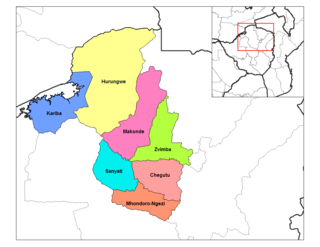
Karoi District is a district of Mashonaland West Province, Zimbabwe. The district is also known as Hurungwe District which extends to Zambian border. The Hurungwe district office are found in Karoi town.

<span class="mw-page-title-main">Chegutu District</span> Place in Mashonaland West, Zimbabwe

Chegutu District is a district of Mashonaland West Province, Zimbabwe. The district headquarters is located in Chegutu, a city which lies of the Harare-Bulawayo Road,.

<span class="mw-page-title-main">Zvimba District</span> Place in Mashonaland West, Zimbabwe

Zvimba District is a district of Mashonaland West Province, Zimbabwe.

Makonde District is a district in Zimbabwe.

Murambinda is a town in Zimbabwe.

Murambinda Mission Hospital (MMH), is a hospital in Zimbabwe. The hospital, also known as Murambinda Hospital, is located in the town of Murambinda, Buhera District, Manicaland Province, in eastern Zimbabwe. Its location is approximately 30 kilometres (19 mi), by road, northeast of the village of Buhera, where the district headquarters are located. This location lies approximately 140 kilometres (87 mi), by road, southwest of the city of Mutare (pop:184,205), the location of the provincial headquarters.

R3 Highway is a primary road in Zimbabwe from the capital city Harare to the Chirundu Border Post with Zambia. It is also known as the A1 Highway. It is part of both the Beira–Lobito Highway and the Cape to Cairo Road.

<span class="mw-page-title-main">Chirundu-Beitbridge Regional Road Corridor</span> Route in Zimbabwe

Chirundu–Beitbridge Road Corridor is a Trans-African Highway Network Zimbabwean link between South Africa and Zambia. It is part of the North–South Corridor Project and forms the entire Zimbabwean section of the Cape to Cairo Road.

The M15 Makuti-Kariba Highway is a 2-way asphalt surface international highway from the A1 Highway at Makuti to Zambia via the Kariba Dam Wall. The maximum speed on this road is 120 kilometres (75 mi) per hour.

References

  1. Citypopulation.de Population of cities & urban localities in Zimbabwe
  2. Road Distance Between Chinhoyi And Karoi With Map
  3. Map Showing Karoi And Harare With Distance Marker
  4. Road Distance Between Karoi And Chirundu With Map
  5. "Tobacco auction floors, MTC clash Archived 23 October 2013 at the Wayback Machine ", ZBC, 12 May 2012
  6. Map Showing Karoi And Kariba With Distance Marker
  7. Pupulation Estimate In 2004
  8. "World Weather Information Service – Karoi". World Meteorological Organization. Retrieved 12 May 2016.
  9. "Karoi Climate Normals 1961–1990". National Oceanic and Atmospheric Administration . Retrieved 10 June 2016.
  10. "Station Karoi" (in French). Meteo Climat. Retrieved 10 June 2016.