Related Research Articles

Harare, formerly Salisbury, is the capital and largest city of Zimbabwe. The city proper has an area of 982.3 km2 (379.3 sq mi), a population of 1,849,600 as of the 2022 census and an estimated 2,487,209 people in its metropolitan province. The city is situated in north-eastern Zimbabwe in the country's Mashonaland region. Harare is a metropolitan province which also incorporates the municipalities of Chitungwiza and Epworth. The city sits on a plateau at an elevation of 1,483 metres above sea level, and its climate falls into the subtropical highland category.

Manicaland is a province in eastern Zimbabwe. After Harare Province, it is the country's second-most populous province, with a population of 2.037 million, as of the 2022 census. Making it the third most densely populated province after Harare and Bulawayo provinces. Manicaland was one of five original provinces established in Southern Rhodesia in the early colonial period. The province endowed with country's major tourist attractions, the likes of Mutarazi Falls, Nyanga National Park and Zimbabwe's top three highest peaks. The province is divided into ten administrative subdivisions of seven rural districts and three towns/councils, including the provincial capital, Mutare. The name Manicaland is derived from one of the province's largest ethnic groups, the Manyika, who originate from the area north of the Manicaland province and as well as western Mozambique, who speak a distinct language called ChiManyika in Shona.

Mashonaland Central is a province of Zimbabwe. It is divided into eight districts and has an area of 28,347 km2 and a population of 1,384,891, representing about 9.1% of the total Zimbabwe population. It is dominated by the Shona speaking locals.

Manica is a province of Mozambique. It has an area of 62,272 km2 and a population of 1,945,994. The province is surrounded by Zimbabwe to the west, Tete Province to the northwest, Sofala Province to the east, the Save River to the south, and the Zambezi river to the northeast. Chimoio is the capital of the province. The highest mountain in Mozambique, Mount Binga, lies in this province near the border with Zimbabwe. The Manica province is divided into nine districts and 34 administrative regions.
Chipinge District is a district in Manicaland Province of eastern Zimbabwe. The administrative headquarters is Chipinge.
Joice Runaida Mujuru, also known by her nom-de-guerre Teurai Ropa Nhongo, is a Zimbabwean revolutionary and politician who served as Vice-President of Zimbabwe from 2004 to 2014. Previously she had served as a government minister. She also served as Vice-President of ZANU–PF. She was married to Solomon Mujuru until his death in 2011 and was long considered a potential successor to President Robert Mugabe, but in 2014 she was denounced for allegedly plotting against Mugabe. As a result of the accusations against her, Mujuru lost both her post as Vice-President and her position in the party leadership. She was expelled from the party a few months later, after which she formed the new Zimbabwe People First party.
The government of Zimbabwe is the main provider of air, rail and road services; historically, there has been little participation of private investors in transport infrastructure.
Mount Darwin may refer to:

The Republic of Zimbabwe is broken down into 10 administrative provinces, which are divided into 64 districts and 1,970 wards.
Mount Darwin is a town in Mashonaland Central province in Zimbabwe.
Mount Pleasant is a residential suburb of Harare, Zimbabwe, located in the northern part of the city. Originally a farm, the area was developed for housing in the early 20th-century and was a white suburb until Zimbabwe's independence in 1980. Today, Mount Pleasant is a multiracial community and is one of Harare's more affluent suburbs.

Nyanga District is located in Manicaland Province of Zimbabwe.
Mudzi District is a district of Mashonaland East Province, Zimbabwe, in southern Africa. It is located in the far eastern part of Zimbabwe. It covers 4,075 square kilometres (1,573 sq mi), all of which is communal land. As of the 2022 census, the district had a population of 158,478, this is up only slightly from the 135,378 of the 2002 census and reflects emigration due to the poverty of the district. It has a single main road, A2, that runs from the town of Mutoko in Mutoko District in the southwest through the district, past the villages of Chifamba, Mudzi, Chingwena, Masarakufa, Nyamuwanga, the town of Kotwa, and the village of Muzezuru to the town of Nyamapanda before entering Mozambique to the northeast.
Mount Darwin Airport is an airport serving Mount Darwin, in Mashonaland Central Province, Zimbabwe. The runway is 1.6 kilometres (0.99 mi) west of the town, and has a 60 metres (200 ft) paved overrun on each end.
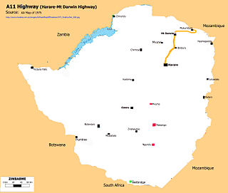
A11 Highway is a national road in Zimbabwe, running from Harare to Bindura through to Mount Darwin. It is also known as the P1 Road, Zimbabwe primary road number 1.
Christopher Tichaona Kuruneri was a Zimbabwean businessman, politician, lawyer, farmer and philanthropist. He was a Minister of Finance, Deputy Minister of Finance and Economic Development and member of parliament for Mount Darwin East. Kuruneri was a member of Zanu-PF. He owned Ascotvale farm in the Mazowe valley in Zimbabwe.
References
- ↑ "Mount Darwin District". GeoNameId : 892597. geonames.org. Retrieved 15 June 2009.
- ↑ "Mount Darwin (District, Zimbabwe) - Population Statistics, Charts, Map and Location". www.citypopulation.de. Retrieved 28 January 2024.
| | This Zimbabwe location article is a stub. You can help Wikipedia by expanding it. |