Manicaland is a province in eastern Zimbabwe. After Harare Province, it is the country's second-most populous province, with a population of 2.037 million, as of the 2022 census. Making it the third most densely populated province after Harare and Bulawayo provinces. Manicaland was one of five original provinces established in Southern Rhodesia in the early colonial period. The province endowed with country's major tourist attractions, the likes of Mutarazi Falls, Nyanga National Park and Zimbabwe's top three highest peaks. The province is divided into ten administrative subdivisions of seven rural districts and three towns/councils, including the provincial capital, Mutare. The name Manicaland is derived from one of the province's largest ethnic groups, the Manyika, who originate from the area north of the Manicaland province and as well as western Mozambique, who speak a distinct language called ChiManyika in Shona.

Mashonaland Central is a province of Zimbabwe. It is divided into eight districts and has an area of 28,347 km2 and a population of 1,384,891, representing about 9.1% of the total Zimbabwe population. It is dominated by the Shona speaking locals.
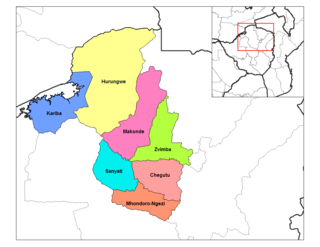
Kariba is a resort town in Mashonaland West province, Zimbabwe, located close to the Kariba Dam at the north-eastern end of Lake Kariba, near the Zambian border. According to the 2022 Population Census, the town had a population of 27,600.

Gwanda is a town in Zimbabwe. It is the capital of the province of Matabeleland South, one of the ten administrative provinces in the country. It is also the district capital of Gwanda District, one of the seven administrative districts in the province.
Juliasdale is a resort town in Manicaland, Zimbabwe. It is situated in the foothills of the Nyanga mountains in eastern Zimbabwe
Sanyati is a town in Zimbabwe.
Lion's Den is a small town in Zimbabwe.

Kadoma, formerly known as Gatooma, is a town in Zimbabwe.
Chinhoyi, previously known as Sinoia during the colonial era, is a city in central northern Zimbabwe in the Makonde District. It has a population of 90,800 and is primarily a college town, although it was originally founded as an Italian group settlement scheme. The nearby Chinhoyi Caves and national park are a popular attraction.
Mutoko is a small town in Mashonaland East province, Zimbabwe. It was established as an administrative station in 1911. It lies 143 km from Harare. It is named after the local chief, Mutoko.

The following outline is provided as an overview of and topical guide to Zimbabwe:
Murombedzi is a town in Zimbabwe.

Karanda Mission Hospital was established in 1961 to meet the needs of mission stations in the Zambezi River valley which were established as churches and then, as the abundant health care challenges were seen, small dispensaries/clinics were developed along with the churches. To help the clinics, the hospital was built. Karanda is in a remote area of northern Zimbabwe nearest to Mount Darwin. Its location is approximately 200 kilometres (120 mi) from the capital, Harare.
Allied Bank, was a commercial bank in Zimbabwe that closed in 2015. The bank regulator cancelled its license on 8 January 2015 after determining that the bank was "no longer in a safe and sound condition, grossly undercapitalised and facing chronic liquidity challenges"

Karoi District is a district of Mashonaland West Province, Zimbabwe. The district is also known as Hurungwe District which extends to Zambian border. The Hurungwe district office are found in Karoi town.

Chegutu, originally known as Hartley, is a district of Mashonaland West Province, Zimbabwe. The district headquarters is located in Chegutu, a city which lies of the Harare-Bulawayo Road,.

Makonde District is a district in Zimbabwe.
Murambinda is a town in Zimbabwe.
Christopher Tichaona Kuruneri was a Zimbabwean businessman, politician, lawyer, farmer and philanthropist. He was a Minister of Finance, Deputy Minister of Finance and Economic Development and member of parliament for Mount Darwin East. Kuruneri was a member of Zanu-PF. He owned Ascotvale farm in the Mazowe valley in Zimbabwe.


