
The Eastern Highlands, also known as the Manica Highlands, is a mountain range on the border of Zimbabwe and Mozambique. The Eastern Highlands extend north and south for about 300 kilometres (190 mi) through Zimbabwe's Manicaland Province and Mozambique's Manica Province.

The Bukit Timah Nature Reserve is a small 1.64 square kilometre nature reserve near the geographic centre of the city-state of Singapore, located on the slopes of Bukit Timah Hill, Singapore's highest hill standing at a height of 163.63 metres, and parts of the surrounding area. The nature reserve is about 12 kilometres from the Downtown Core, Singapore's central business district.
An Important Bird and Biodiversity Area (IBA) is an area identified using an internationally agreed set of criteria as being globally important for the conservation of bird populations.
The Nguru Mountains are a mountain range in Morogoro Region, Tanzania, Africa. The Nguru Mountains are part of the Eastern Arc Mountains. The mountains are predominantly covered with rainforest, home to 83 species of birds and African violets. There are a number of forest reserves in the mountains.
The Kipengere Range, also known as the Livingstone Mountains, lies in southwest Tanzania at the northern end of Lake Malawi. Near Lake Malawi they are known as the Kinga Mountains. It is a plateau-like ridge of mountains running southeastwards from the basin of the Great Ruaha River in the north to that of the Ruhuhu River in the south, and forms part of the eastern escarpment of the East African Rift. The range is mostly clad in montane grasslands, renowned for their botanical diversity and displays of flowers, with montane evergreen forests mostly in stream valleys.
The Udzungwa Mountains are a mountain range in south-central Tanzania. The mountains are mostly within Iringa Region, south of Tanzania's capital Dodoma. The Udzungwa Mountains are part of the Eastern Arc Mountains, and are home to a biodiverse community of flora and fauna with large numbers of endemic species.

The Bvumba Mountains or Vumba Mountains straddle the Zimbabwe-Mozambique border, and are situated some 10 km south east of Mutare. The Bvumba rise to Castle Beacon at 1,911 metres, and are, together with the Chimanimani Mountains to the south and Nyanga Mountains to the north, part of the Eastern Highlands of the Manicaland and adjacent Manica provinces. They are referred to as the "Mountains of the Mist", as so often the early morning starts with a mist which clears by mid-morning. Although lying mostly within Zimbabwe, the mountains extend north-eastward to Mount Vumba in Mozambique. They are capped by cool, green hills which shelter country hotels, a casino and golf course at the Leopard Rock Hotel and a Botanical Garden with one of the best views in Africa. The mountains are also known for their coffee plantations.
The South West Slopes is a region predominantly in New South Wales, Australia. It covers the lower inland slopes of the Great Dividing Range extending from north of Cowra through southern NSW into western Victoria. More than 90% of the region is in the state of New South Wales and it occupies about 10% of that state.
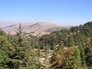
Al Shouf Cedar Nature Reserve is a nature reserve in the Chouf District of Lebanon. It is located on the slopes of Jebel Baruk mountain and has an area of 550 km2 (210 sq mi), nearly 5.3% of the Lebanese territory.

Livingstone is a national park and state conservation area located 30 kilometres (19 mi) south of Wagga Wagga and 10 kilometres (6.2 mi) east of Mangoplah, in the South West Slopes region of south western New South Wales.
New Amarambalam Wildlife Sanctuary is a wildlife sanctuary in the Western Ghats, situated in the Malappuram District of Kerala state in South India.It extends till Silent Valley National Park of the Palakkad District to the south and to Nadugani in the Nilgiri District of Tamil Nadu to the North.

The Hunter Estuary Wetlands comprise a group of associated wetlands at and near the mouth of the Hunter River in the city of Newcastle, New South Wales, Australia. Some 30 km2 of the wetlands has been recognised as being of international importance by designation under the Ramsar Convention. It was listed on 21 February 1984 as Ramsar site 287. A larger area of the wetlands has been identified by BirdLife International as an Important Bird Area (IBA). The wetlands are recognised as the most important area in New South Wales for waders, or shorebirds.

The Araluen-Wungong Important Bird Area is a 123 km2 tract of land in the Darling Ranges on the south-eastern fringe of the city of Perth, Western Australia. The name derives from the Araluen Botanic Park within the Important Bird Area (IBA) and the adjacent suburb of Wungong. It is an important site for black cockatoos.
The Itombwe Mountains are a range of mountains in the South Kivu province of the Democratic Republic of the Congo (DRC). They run along the west shore of the northern part of Lake Tanganyika. They contain a vast area of contiguous montane forest and are home to a rich diversity of wildlife.

Plaine des Chicots – Plaine d'Affouches Important Bird Area is a 3688 ha tract of land on the island of Réunion, a French territory in the western Indian Ocean.
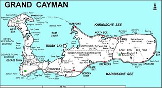
The Botanic Park and Salina Reserve Important Bird Area comprises two separate sites on Grand Cayman, one of the Cayman Islands, a British Overseas Territory in the Caribbean Sea.
Big Tree is the tallest native or indigenous tree in Zimbabwe, and a declared National Monument. The tree is 65 m tall and measures 4.5 m in diameter, while its age is estimated at 1,000 years or over. This impressive tree is growing in the centre of the Chirinda Forest in the south east of Zimbabwe at the southernmost part of the country's Eastern Highlands. Big tree is a Khaya anthotheca or Nyasa redwood tree. In December 1986 it was measured at 65 metres tall and 5 1/4 metres in diameter. The trunk is very heavily and hugely buttressed at the base that makes measuring difficult.
The 950 hectares Chirinda Forest Botanical Reserve is situated on the slopes of Mount Selinda, 30 km south of Chipinge, in the Chipinge Highlands of Manicaland, Zimbabwe, and is administered by the Forestry Commission. The reserve is situated at between 900 and 1,200 m in altitude, and receives some 1,370 mm (54 in) to 1,466 mm (57.7 in) of annual rainfall. 606 hectares of its higher levels, above 1,076 m (3,530 ft), is covered by moist evergreen forest, specifically Zanzibar-Inhambane transitional rain forest, of which it represents the southernmost occurrence. The headwaters of three streams, namely the Zona, Chinyika and Musangazi, drain the two broad highlands which it encloses. The boundaries of the reserve are not strictly enforced, so that cattle grazing and plant harvesting are ongoing. The reserve is surrounded by communal settlements, commercial timber plantations and small-scale commercial farming units. The naturalist Charles Swynnerton was appointed manager of the nearby Gungunyana farm in 1900, and a number of plant, bird and insect names commemorate his collecting activities of the next two decades. Chirinda means "lookout" or "vantage point" in the chiNdau language, or perhaps "place of refuge".

The Ukaguru Mountains are a mountain range in central Tanzania. The mountains are in Morogoro region, east of Tanzania's capital Dodoma. The mountains are named for the Kaguru people. The Ukaguru Mountains are part of the Eastern Arc Mountains, and are home to a biodiverse community of flora and fauna with large numbers of endemic species.

Mutare District is a district in Manicaland Province of eastern Zimbabwe. The district headquarters is the city of Mutare.
