
The Serpentine is a 40-acre (16 ha) recreational lake in Hyde Park, London, England, created in 1730 at the behest of Queen Caroline. Although it is common to refer to the entire body of water as the Serpentine, strictly the name refers only to the eastern half of the lake. Serpentine Bridge, which marks the boundary between Hyde Park and Kensington Gardens, also marks the Serpentine's western boundary; the long and narrow western half of the lake is known as the Long Water. The Serpentine takes its name from its snakelike, curving shape, although it only has one bend.

Masvingo, originally Victoria, is a province in southeastern Zimbabwe. It has a population of 1.485 million as of the 2012 census, ranking fifth out of Zimbabwe's ten provinces. Established by the British South Africa Company, it was one of the five original provinces of Southern Rhodesia. In 1982, two years after Zimbabwean independence, it was renamed Masvingo Province. The province is divided into seven districts, including Masvingo District, which contains the provincial capital Masvingo City.

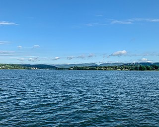
Masvingo, originally known as Fort Victoria, is a city in south-eastern Zimbabwe and the capital of Masvingo Province. The city is situated close to Great Zimbabwe, the national monument from which the country takes its name and close to Lake Mutirikwi, its recreational park, the Kyle dam and the Kyle National Reserve where there are many different animal species. It is mostly populated by the Karanga people who form the biggest branch of the various Shona tribes in Zimbabwe.

Lake Burley Griffin is an artificial lake in the centre of Canberra, the capital of Australia. It was completed in 1963 after the Molonglo River, which ran between the city centre and Parliamentary Triangle, was dammed. It is named after Walter Burley Griffin, the American architect who won the competition to design the city of Canberra.

Lake Kariba is the world's largest artificial lake and reservoir by volume. It lies 1,300 kilometres (810 mi) upstream from the Indian Ocean, along the border between Zambia and Zimbabwe. Lake Kariba was filled between 1958 and 1963 following the completion of the Kariba Dam at its northeastern end, flooding the Kariba Gorge on the Zambezi River.

Zimbabwe Parks and Wildlife Management Authority (Zimparks) is an agency of the Zimbabwe government managing national parks. Zimbabwe's game reserves are managed by the government. They were initially founded as a means of using unproductive land.

Nyanga National Park lies in the north of Zimbabwe's Eastern Highlands. One of the first national parks to be declared in the country, it contains the highest land in Zimbabwe, with green hills and perennial rivers. Most of its terrain consists of rolling downland, sometimes lightly wooded, lying at altitudes between 1,800–2,593 metres. Mount Nyangani, the highest point in Zimbabwe, lies in the centre of the park and Mutarazi Falls, Zimbabwe's highest waterfall, is in the south of the park. Nyanga National park incorporates the former Mutarazi Falls National Park on its southern boundary.
Smith Mountain Lake is a large reservoir in the Roanoke Region of Virginia, United States, located southeast of the City of Roanoke and southwest of Lynchburg. The lake was created in 1963 by the Smith Mountain Dam impounding the Roanoke River. The majority of the south shore of the lake lies in Franklin County while a small portion, including access to the dam, lies in Pittsylvania County. Bedford County makes up the northern half of the lake with the Roanoke River as the dividing line. The lake has become a popular recreation spot and has also experienced significant development in the last decade. It is the largest lake contained entirely within the Commonwealth of Virginia.

Curecanti National Recreation Area is a National Park Service unit located on the Gunnison River in western Colorado. Established in 1965, Curecanti National Recreation Area is responsible for developing and managing recreational facilities on three reservoirs, Blue Mesa Reservoir, Morrow Point Reservoir and Crystal Reservoir, constructed on the upper Gunnison River in the 1960s by the U.S. Bureau of Reclamation to better utilize the vital waters of the Colorado River and its major tributaries. A popular destination for boating and fishing, Curecanti offers visitors two marinas, traditional and group campgrounds, hiking trails, boat launches, and boat-in campsites. The state's premiere lake trout and Kokanee salmon fisheries, Curecanti is a popular destination for boating and fishing, and is also a popular area for ice-fishing in the winter months.

Lake Burbury is a man-made water reservoir created by the Crotty Dam inundating the upper King River valley that lies east of the West Coast Range. Discharge from the reservoir feeds the John Butters Hydroelectric Power Station, owned and operated by Hydro Tasmania.
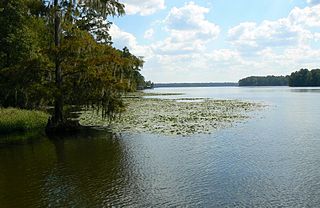
Lake Talquin is a reservoir located on the Ochlockonee River between Leon County and Gadsden County in north Florida. The lake, located about 10 miles (15 km) west of Tallahassee, is south of Interstate 10 and bordered by State Road 20 on the east and State Road 267 on the west.

Blue Mesa Reservoir is an artificial reservoir located on the upper reaches of the Gunnison River in Gunnison County, Colorado. The largest lake located entirely within the state, Blue Mesa Reservoir was created by the construction of Blue Mesa Dam, a 390-foot tall earthen fill dam constructed on the Gunnison by the U.S. Bureau of Reclamation in 1966 for the generation of hydroelectric power. Managed as part of the Curecanti National Recreation Area, a unit of the National Park Service, Blue Mesa Reservoir is the largest lake trout and Kokanee salmon fishery in Colorado.

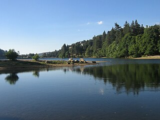
Gull Lake is a large lake in central Alberta, Canada. It is a popular recreational lake with its southern shores boasting large sandy beaches. Gull Lake is centrally located between Edmonton and Calgary and lies in two counties, Ponoka County and Lacombe County. The lake is accessed west of Ponoka on Highway 53 to get to the north side, or west of Lacombe on Highway 12 to reach the southern shores.
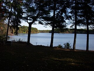
Lake Cochituate is a body of water in Natick, Wayland, and Framingham, Massachusetts, United States. Originally a reservoir serving Boston, it no longer serves that function, and is now a local recreational resource and home to Cochituate State Park.
Lake Gregory is a reservoir in the San Bernardino National Forest of the San Bernardino Mountains in San Bernardino County, California. The lake and the surrounding area make up the Lake Gregory Regional Park adjacent to Crestline, California.
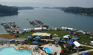
Cherokee Lake, also known as Cherokee Reservoir, is an artificial reservoir in the U.S. state of Tennessee formed by the impoundment of the Holston River behind Cherokee Dam.

John Redmond Reservoir is a reservoir on the Neosho River in eastern Kansas. Built and managed by the U.S. Army Corps of Engineers, it is used for flood control, recreation, water supply, and wildlife management. It borders the Flint Hills National Wildlife Refuge to the northwest.
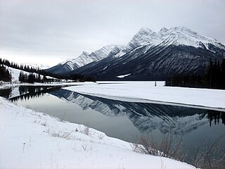
Spray Lakes Reservoir is a reservoir in Alberta, Canada. The Spray Lakes were a string of lakes formed along the Spray River, a tributary of the Bow River. With the damming of the river, the lakes were united in the Spray Lakes Reservoir.
Manjirenji Dam, formerly known as Lake McDougal, lies in south eastern Zimbabwe, east of Masvingo. It was built to provide irrigation water to the farming estates on the lowveld to the southwest, around the town of Chiredzi, where the main crop has been sugar cane.
Bangala Dam lies in south-eastern Zimbabwe, south of Masvingo. It was built by Concor to provide irrigation water to the farming estates on the lowveld to the southwest, around the town of Triangle, where the main crop has been sugar cane.

