Related Research Articles

Portuguese Mozambique or Portuguese East Africa were the common terms by which Mozambique was designated during the period in which it was a Portuguese colony. Portuguese Mozambique originally constituted a string of Portuguese possessions along the south-east African coast, and later became a unified colony, which now forms the Republic of Mozambique.

Portuguese colonization of the Americas constituted territories in the Americas belonging to the Kingdom of Portugal. Portugal was the leading country in the European exploration of the world in the 15th century. The Treaty of Tordesillas in 1494 divided the Earth outside Europe into Castilian and Portuguese global territorial hemispheres for exclusive conquest and colonization. Portugal colonized parts of South America, but also made some unsuccessful attempts to colonize North America.

Pedro Álvares Cabral was a Portuguese nobleman, military commander, navigator and explorer regarded as the European discoverer of Brazil. In 1500, Cabral conducted the first substantial exploration of the northeast coast of South America and claimed it for Portugal. While details of Cabral's early life remain unclear, it is known that he came from a minor noble family and received a good education. He was appointed to head an expedition to India in 1500, following Vasco da Gama's newly-opened route around Africa. The undertaking had the aim of returning with valuable spices and of establishing trade relations in India—bypassing the monopoly on the spice trade then in the hands of Arab, Turkish and Italian merchants. Although the previous expedition of Vasco da Gama to India, on its sea route, had recorded signs of land west of the southern Atlantic Ocean, Cabral led the first known expedition to have touched four continents: Europe, Africa, America, and Asia.

The British Central Africa Protectorate (BCA) was a British protectorate proclaimed in 1889 and ratified in 1891 that occupied the same area as present-day Malawi: it was renamed Nyasaland in 1907. British interest in the area arose from visits made by David Livingstone from 1858 onward during his exploration of the Zambezi area. This encouraged missionary activity that started in the 1860s, undertaken by the Universities' Mission to Central Africa, the Church of Scotland and the Free Church of Scotland, and which was followed by a small number of settlers. The Portuguese government attempted to claim much of the area in which the missionaries and settlers operated, but this was disputed by the British government. To forestall a Portuguese expedition claiming effective occupation, a protectorate was proclaimed, first over the south of this area, then over the whole of it in 1889. After negotiations with the Portuguese and German governments on its boundaries, the protectorate was formally ratified by the British government in May 1891.

Conquistadors or conquistadores were the explorer-soldiers of the Spanish and Portuguese Empires of the 15th and 16th Centuries. During the Age of Discovery, conquistadors sailed beyond Europe to the Americas, Oceania, Africa, and Asia, colonizing and opening trade routes. They brought much of the Americas under the dominion of Spain and Portugal.

The military history of Portugal is as long as the history of the country, from before the emergence of the independent Portuguese state.

The Portuguese Navy is the naval branch of the Portuguese Armed Forces which, in cooperation and integrated with the other branches of the Portuguese military, is charged with the military defense of Portugal.
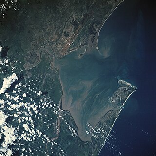
Maputo Bay, formerly also known as Delagoa Bay from Baía da Lagoa in Portuguese, is an inlet of the Indian Ocean on the coast of Mozambique, between 25° 40' and 26° 20' S, with a length from north to south of over 90 km long and 32 km wide.

Alexandre Alberto da Rocha de Serpa Pinto, Viscount of Serpa Pinto was a Portuguese explorer of southern Africa and a colonial administrator.
The Roosevelt–Rondon Scientific Expedition was a survey expedition in 1913–14 to follow the path of the Rio da Dúvida in the Amazon basin. The expedition was jointly led by Theodore Roosevelt, the former President of the United States, and Colonel Cândido Rondon, the Brazilian explorer who had discovered its headwaters in 1909. Sponsored in part by the American Museum of Natural History, they also collected many new animal and insect specimens. The river was eventually named "Rio Roosevelt" for the former president, who nearly died during the voyage.

The 1890 British Ultimatum was an ultimatum by the British government delivered on 11 January 1890 to the Kingdom of Portugal. The ultimatum forced the retreat of Portuguese military forces from areas which had been claimed by Portugal on the basis of historical discovery and recent exploration, but which the United Kingdom claimed on the basis of effective occupation. Portugal had attempted to claim a large area of land between its colonies of Mozambique and Angola including most of present-day Zimbabwe and Zambia and a large part of Malawi, which had been included in Portugal's "Rose-coloured Map".
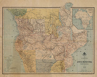
The Pink Map, also known in English as the Rose-Coloured Map, was a map prepared in 1885 to represent Portugal's claim of sovereignty over a land corridor connecting their colonies of Angola and Mozambique during the Scramble for Africa. The area claimed included most of what is currently Zimbabwe and large parts of modern Zambia and Malawi. In the first half of the 19th century, Portugal fully controlled only a few coastal towns in Angola and Mozambique. It also claimed suzerainty over other almost independent towns and nominally Portuguese subjects in the Zambezi valley, but could rarely enforce its claims; most of the territory now within Angola and Mozambique was entirely independent of Portuguese control. Between 1840 and 1869, Portugal expanded the area it controlled but felt threatened by the activities of other powers.

Portuguese discoveries are the numerous territories and maritime routes recorded by the Portuguese as a result of their intensive maritime exploration during the 15th and 16th centuries. Portuguese sailors were at the vanguard of European exploration, chronicling and mapping the coasts of Africa and Asia, then known as the East Indies, and Canada and Brazil, in what came to be known as the Age of Discovery.
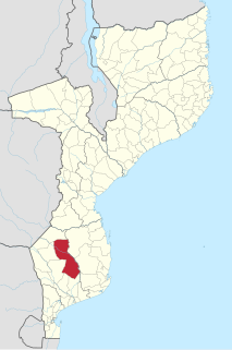
Chigubo District is a district of Gaza Province in south-western Mozambique. The administrative center of the district is Dindiza. The district is located in the east of the province, and borders with Massangena District in the north, Mabote and Funhalouro Districts of Inhambane Province in the east, Chibuto District in the south, Guijá District in the southwest, Mabalane District in the west, and with Chicualacuala District in the northwest. The area of the district is 14,864 square kilometres (5,739 sq mi). It has a population of 20,685 (2007).

Massangena District is a district of Gaza Province in south-western Mozambique. The administrative center of the district is Massangena. The district is located in the north of the province, and borders with Machaze District of Manica Province in the north, Mabote District of Inhambane Province in the east, Chigubo District in the southeast, Chicualacuala District in the south, and with Chiredzi District of Zimbabwe in the west. The area of the district is 7,481 square kilometres (2,888 sq mi). It has a population of 15,637 (2007).
The exploration of North America by European sailors and geographers was an effort by major European powers to map and explore the continent with the goal of economic, religious and military expansion. The combative and rapid nature of this exploration is the result of a series of countering actions by neighboring European nations to ensure no single country had garnered enough wealth and power from the Americas to militarily tip the scales over on the European continent. It spanned the late 15th to early 17th centuries, and consisted primarily of expeditions funded by Spain, England, France and Portugal. See also the European colonization of the Americas
The Anglo-Portuguese Treaty of 1891 was an agreement between Great Britain and Portugal which fixed the boundaries between the British Central Africa Protectorate, and the territories administered by the British South Africa Company in Mashonaland and Matabeleland and North-Western Rhodesia and Portuguese Mozambique, and also between the British South Africa Company administered territories of North-Eastern Rhodesia, and Portuguese Angola.

The Battle of Bayang was the first major engagement of the Moro Rebellion. It was a punitive expedition led by Colonel Frank D. Baldwin in retaliation for murders committed by Moros in Malabang and Parang on the island of Mindanao. Col. Baldwin led seven companies of the 27th Infantry and the 25th Battery Light Artillery against the Moros on the south shore of Lake Lanao, the village of Bayang in particular. The Americans took Fort Pandapatan and the fort of Datu of Binadayan, killing the Sultan of Bayang in the process.

The Portuguese discovery of the sea route to India was the first recorded trip directly from Europe to India, via the Cape of Good Hope. Under the command of Portuguese explorer Vasco da Gama, it was undertaken during the reign of King Manuel I in 1495–1499. Considered one of the most remarkable voyages of the Age of Discovery, it initiated the Portuguese maritime and trade presence in Kerala and the Indian Ocean.
References
- ↑ Florilégio by João Maria Ferreira
Coordinates: 21°32′16″S32°57′23″E / 21.53778°S 32.95639°E
| | This Mozambique location article is a stub. You can help Wikipedia by expanding it. |