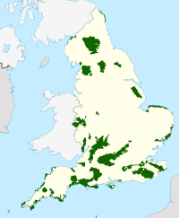
The North Devon Coast is a designated Area of Outstanding Natural Beauty in Devon, England, designated in September 1959. The AONB contributes to a family of protected landscapes in the Southwest of England and a total of 38% of the region is classified by the International Union for Conservation of Nature as Category V Protected Landscapes. The twelve Areas of Outstanding Natural Beauty extend to 30% of the region, twice the proportion covered by AONBs in England as a whole and a further two National Parks, Dartmoor and Exmoor, cover an additional 7%.
The North Devon Coast AONB covers 171 square kilometres (66sqmi) of mainly coastal landscape from the border of Exmoor National Park at Combe Martin, through the mouth of the Taw & Torridge Estuary to the Cornish border at Marsland Mouth. The dune system at Braunton Burrows forms the core area of North Devon's Biosphere Reserve, the first "new style" Unesco-designated reserve in the United Kingdom. The whole of the AONB is within the Reserve boundaries.
Overview
The North Devon Coast was first considered to require some form of national landscape protection in 1953 and was originally intended to be part of the Exmoor National Park. The Torridge section was to be part of the proposed Cornwall Coast National Park. This was not to be, and by 1956 Devon County Council had agreed that the North and South Devon Coasts should be considered as AONBs.
The National Parks Commission were asked to draw up a proposed boundary to submit to the County Council and there was consultation with the Urban and Rural District Councils concerned. Initially, it was proposed that most of Combe Martin village be excluded because of bad disfigurement by electricity and telephone cables. The suggested boundary largely followed the Area of Special Landscape Value, which was a County Council designation. There followed a period of consultation and modification e.g. Northam Burrows was added. Following public advertisement only one representation was received this was from a resident concerned about his proposal to develop a holiday camp at Watermouth. Ultimately, in September 1959, the North Devon AONB was the first AONB in Devon to be designated and confirmed in May 1960, just two months ahead of South Devon.
For many years, the AONB had no specific management service, however in the early 1990s, a Heritage Coast Service managed the two defined Heritage Coasts which have similar boundaries to the AONB. In 2002 Braunton Burrows, within the AONB, was re-designated as the core of a Biosphere Reserve under the revised UNESCO Man and the Biosphere Programme, providing international recognition for the area. This was closely followed by the establishment of the North Devon AONB Partnership in 2004 with a small staff unit to support it. There is a close relationship between the AONB management and that of the North Devon UNESCO Biosphere Reserve with reciprocal partnership membership.
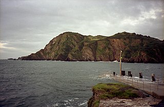
The North Devon AONB contains a surprising diversity of scenery including tall rugged cliffs, wave cut platforms, wide sandy bays, sand dunes, traditional hedged fields with wind sculptured trees, steep sided wooded combes and woodland that runs right to the cliff edge. Encompassed within the designated area is the dramatic coastline of the Hartland promontory, the calm tranquillity of Bideford Bay, the internationally important conservation sites that flank the Taw and Torridge Estuary, the striking headlands and golden beaches of the North Devon Downs and the secluded coves and bays of the North Devon High Coast. North Devon's coastline face the Atlantic Ocean and the Bristol Channel.
In 2006-7 Devon County Council, in partnership with Natural England, the Devon AONBs and other local authorities, commissioned a study of the North Devon landscape. As a result, the AONB has been classified into 11 Landscape Character Types.
Open coastal plateaux
Found along the Atlantic Coast between Bude and Ilfracombe, frequently interrupted by lower-lying landscape types, especially between Westward Ho! and Woolacombe. This type is characterised by dense low hedges (often elm) with occasional hedgerow oaks, little woodland, few roads but many rights of way, very low settlement density, influence of geology on land form, and extensive views along the coast.
Farmed lowland moorland
Lying inland from Hartland Point, between Clovelly and Welcombe, this landscape type is characterised by very flat moorland, predominantly inland character with small coastal fringe, pastoral cultivation with dominant conifer plantations, notably regular field patterns with areas of unenclosed moorland heath and scrub, shallow streams and rush-dominated roadside ditches indicative of impeded drainage, sparse settlement pattern of hamlets and isolated farms with some tourism and leisure uses, and a sparse highway network of narrow straight lanes.
Scarp Slopes
Mainly at intervals along the western Atlantic coast to the south of Hartland Point this type landscape type is characterised by narrow, steep individual or multiple branching valley systems, dense woodland, predominantly with broadleaf trees, small areas of pasture and scrub with irregular small-scale field patterns marked by low hedgebanks, extremely sparsely settled with stone as dominant building material, limited or absent road network, limited vehicle access to coast and coastal rights of way, and scattered with tranquil and remote enclosed in combes.
Settled coastal slopes and combes
Facing north to the Atlantic around Ilfracombe and Clovelly this landscape type is characterised by steeply sloping narrow valley systems, a mix of unenclosed woodland and small to medium irregular fields with wide hedgebanks, pasture with frequent wet pasture and horse paddocks, extensive linear settlement just above narrow, flat valley floor, with Victorian architecture and small scale 20th Century ‘resort’ development, sparse winding narrow lanes, and lush vegetation.
Steep open slopes
This west-facing coastal type between Morte Point and Braunton, overlooking series of sandy beaches, is characterised by sloping hillside adjoining but not part of coastal cliffs, open pastoral farmland without woods or trees but with low hedges and hedgebanks, mix of pasture, rough grazing and low scrub, regular field patterns of variable size, limited network of minor roads, smallscale hamlets of vernacular style or extensive coastal settlements with much leisure-related development, and extensive coastal views
Valley Slopes
These small areas above the beaches and dunes at Croyde and Braunton are characterised by their gently rolling landform sloping up from valley floor, small fields with medium to tall boundaries, a variety of building ages, styles and settlement size, much leisure-related development with strong influence of coastal or marine activities, much use of stone, winding narrow lanes, streams, and largely tranquil out of season.
Valley Floors
Related to the Braunton Great Field and Braunton Marsh, this landscape type is set back from the river Taw to the south and protected from westerly maritime influence by Saunton Sands and Braunton Burrows. Its key characteristics include; open flat landform, often with distinct vegetated floodplain edge, shallow watercourses screened by riparian vegetation, pastoral or arable land use with variable field sizes, rare survival of medieval open field strip system (Braunton Great Field), unenclosed or with stone walls and hedges as well as drainage ditches, unsettled, narrow winding lanes, open internally with views out screened by boundary vegetation, estuarine or river valley character and exceedingly tranquil.
Unsettled marine levels
Predominantly centred on the Skern mudflats on the southern flank of Taw/Torridge estuary this character type is distinguishable as a flat unsettled river valley, with marine influence on terrestrial habitats. Its proximity to roads and settlements in adjoining areas reduces tranquillity, however it retains traditional floodplain habitats and a high level of biodiversity.
Inter-tidal sands
Either side of the Taw Torridge estuary mouth and further north along north-western Devon coast (Woolacombe, Putsborough, Croyde, Saunton and Westward Ho! beaches this landscape type is characterised by enormous flat sandy beaches, extensive recreational use, a protected by pebble ridge, low rocks, cliffs and dune systems, unenclosed, unsettled and without roads, good access but few footpaths and with extensive views along the coast.
Coastal dunes
Along north-western Devon coast, to east of extensive beaches and characterised by its extensive dune systems, this landscape type has been recognised as internationally important for its biodiversity. Other characteristics include extensive recreational use, some rush-dominated pasture, almost entirely unsettled and without roads and is open but not exposed except along western edge.
Cliffs
To the north and west coasts of North Devon, excluding Taw-Torridge estuary, this landscape type demonstrates near-vertical, steeply sloping cliffs which remain unsettled and inaccessible. Scattered with narrow shingle beaches, small stony coves or rocky foreshore at foot of cliffs, these areas are only accessible along cliff top via South West Coast Path where there are also extensive views along coastline.
Wildlife
The landscapes of the North Devon AONB encompass a fantastic habitat resource for wildlife. These include the culm grasslands around Hartland, the coastal woodlands near Clovelly, the heathlands around Hartland and Morte Point and the extensive sand dune systems at Braunton and Northam Burrows. From the floral orchids of the sand dunes, the bluebells of the coastal combes, to the birds and insects of the coastal heaths these varied habitats support a rich variety wildlife. The AONB also contains a wealth of historic and archaeological sites with buildings and old field patterns that reflect the progress of man from pre-historic times to the present day.
Community and economy
Approximately 12,000 people live within the AONB, the largest settlements being Combe Martin and Hartland. Other well known villages include the picturesque villages of Clovelly, Berrynarbor, and Croyde. The larger settlements of Ilfracombe, Bideford and Braunton lie on the very edge of the designated area and provide excellent 'gateway' towns into the AONB. The economy of the AONB is dominated by agriculture and tourism which has had a major influence on the landscape of the area.
North Devon is a local government district in Devon, England. North Devon Council is based in Barnstaple. Other towns and villages in the North Devon District include Braunton, Fremington, Ilfracombe, Instow, South Molton, Lynton and Lynmouth. The district was formed on 1 April 1974 as a merger of the Barnstaple municipal borough, the Ilfracombe and Lynton urban districts, and the Barnstaple and South Molton rural districts.
Braunton is a large village, civil parish, ecclesiastical parish and former manor in Devon. The village is situated 5 miles (8 km) west of Barnstaple. It is one of the largest villages in Devon with a population at the 2021 census of 10,217 people. There are two electoral wards. Their joint population at the above census was 8,218. Within the parish is the fertile, low-lying Braunton Great Field, which adjoins the undulating Braunton Burrows, the Core Area in North Devon Biosphere Reserve, the largest psammosere in England. It confronts the Atlantic Ocean at the west of the parish at the large beach of Saunton Sands, one of the South West's international-standard surfing beaches.
Croyde is a village on the west-facing coastline of North Devon, England. The village lies on the South West Coast Path near to Baggy Point, which is owned by the National Trust. It lies within the North Devon Coast Area of Outstanding Natural Beauty. Croyde village and its beach faces the Atlantic Ocean near the western limit of the Bristol Channel.
Northam is a market town, civil parish and electoral ward in Devon, England, lying north of Bideford. The civil parish also includes the villages of Westward Ho!, Appledore, West Appledore, Diddywell, Buckleigh and Silford, and the residential areas of Orchard Hill and Raleigh Estate. The population at the 2011 census was 5,427.
Appledore is a village at the mouth of the River Torridge, about 6 miles (10 km) west of Barnstaple and about 3 miles (5 km) north of Bideford in the county of Devon, England. It is the home of Appledore Shipbuilders, a lifeboat slipway and Hocking's Ice Cream, a brand of ice cream only sold in North Devon. There are numerous shops, cafes and galleries. The local football club is Appledore F.C. The ward population at the 2011 census increased to 2,814.
Instow is a village in north Devon, England. It is on the estuary where the rivers Taw and Torridge meet, between the villages of Westleigh and Yelland and on the opposite bank to Appledore. There is an electoral ward with the same name. The ward's total population at the 2011 census was 1,501.
The River Taw rises at Taw Head, a spring on the central northern flanks of Dartmoor, crosses North Devon and at the town of Barnstaple, formerly a significant port, empties into Bideford Bay in the Bristol Channel, having formed a large estuary of wide meanders which at its western end is the estuary of the River Torridge.
The Tarka Trail is a series of footpaths and cyclepaths around north Devon, England that follow the route taken by the fictional Tarka the Otter in the book of that name. It covers a total of 180 miles (290 km) in a figure-of-eight route, centred on Barnstaple.
Saunton is a village located approximately two miles from Braunton on the North Devon coast in the South West of England.
Braunton Burrows is a sand dune system on the North Devon coast. It is privately owned and forms part of the Christie Devon Estates Trust. Braunton Burrows is a prime British sand dune site, the largest sand dune system (psammosere) in England. It is particularly important ecologically because it includes the complete successional range of dune plant communities, with over 470 vascular plant species. The short turf communities are very rich in lichens and herbs, and the dune slacks are also rich. The many rare plants and animals include 14 with UK Biodiversity Action Plans. For example, this is one of only two sites in the UK for the Amber Sandbowl Snail Catinella arenaria, which is found on the wet dune slacks.
Hillsborough is a local nature reserve in Ilfracombe, North Devon. It is known locally as the sleeping elephant. It was bought by the local council in the late nineteenth century to prevent development on the site. As well as a pleasant coastal area where visitors may roam, it includes the remains of an Iron Age hill fort.
The North Devon Football League is a football competition based in England. It was established in 1904. The top division of this league, which is the Premier Division, sits at level 12 of the English football league system and is a feeder to the new Devon Football League since 2019, and prior to that, the South West Peninsula League. The North Devon Gazette sponsors the league and so the full, sponsored name of the league is the North Devon Gazette Football League.
Saunton Sands is a beach near the English village of Saunton on the North Devon coast near Braunton, popular for longboard surfing. Beyond its southern end, Crow Point, England is the mouth of the River Taw estuary. It is part of the Taw-Torridge estuary Area of Outstanding Natural Beauty and is at the centre of the UNESCO-designated North Devon's Biosphere Reserve, where Braunton Burrows lies at the heart.
Bideford Bay, also known as Barnstaple Bay and often shown on maps as Barnstaple or Bideford Bay, is a large area of water on the northwest coast of Devon in South West England, at the southwestern end of the Bristol Channel where it joins the Celtic Sea. The bay extends from Hartland Point in the southwest to Baggy point the northeast, and is partly sheltered by the island of Lundy, 12 miles (19 km) offshore. It takes its alternative names from the towns of Bideford and Barnstaple, located respectively on the rivers Torridge and Taw which flow into the bay. The alternative spelling Barnstable Bay, in use long after that spelling became obsolete for the town, is also sometimes seen.
Appledore Lifeboat Station is the base for Royal National Lifeboat Institution (RNLI) search and rescue operations at Appledore, Devon in the United Kingdom. The first lifeboat was stationed in the town in 1825 and the present station was opened in 2001. It operates a Tamar-class all weather boat (AWB) and an Atlantic 85 B Class inshore lifeboat (ILB).
North Devon's Biosphere Reserve is a UNESCO biosphere reserve in North Devon. It covers 55 square miles (140 km2) and is centred on Braunton Burrows, the largest sand dune system (psammosere) in England. The boundaries of the reserve follow the edges of the conjoined catchment basin of the Rivers Taw and the Torridge and stretch out to sea to include the island of Lundy. The biosphere reserve is primarily lowland farmland, and includes many protected sites including 63 Sites of Special Scientific Interest which protect habitats such as culm grassland and broadleaved woodlands. The most populous settlements in its buffer area are Barnstaple, Bideford, Northam, Ilfracombe, and Okehampton.
Mermaid's Pool to Rowden Gut is a geological Site of Special Scientific Interest (SSSI) in north-western Devon in England. It comprises a 5.5km-long stretch of coast between Mermaid's Pool in the north-east and Rowden's Gut in the south-west. The sea cliffs expose the only available complete sequence through the Bideford Formation of the Culm Measures, which consists of alternating layers of mudstones, siltstones and sandstones that were deposited in a wide range of deltaic environments during the Carboniferous period. This site borders the Westward Ho! Cliffs SSSI to the north, while the coastline to the south-east continues to Peppercombe, and further into the Hobby to Peppercombe SSSI.
This page is based on this Wikipedia article Text is available under the CC BY-SA 4.0 license; additional terms may apply. Images, videos and audio are available under their respective licenses.